


![]()
You are here
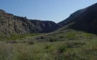
Ridge Big Balkhan.
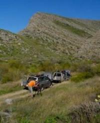
Wildlife Tours in Turkmenistan.
“Sweetness shudders through the land
as if, freed from the heat,
nature’d scooped spring waters in her hand
and splashed her burning feet”
Fyodor Ivanovich Tyutchev. “Summer evening”.
Flower Tours in Turkmenistan.
The Big Balkhan Range is located between the Darja Peninsula, which is located in the northwestern part of the Big Balkhan, between the Darjakum sands located in the southwestern part of the Big Balkhan, the Kelkor saline land in the southwest, the Chilmamedkum sands in the west and northwest and the Karakum desert in the west, by the Small Balkhan ridge in the southwest in the Balkan velayat in the western part of Turkmenistan.
The ridge is located in the western part of Turkmenistan in the Balkan velayat. The Big Balkhan tectonically refers to the Alpine geosynclinal region (the Cenozoic fold region of the Tethys) on the basis of geological data to be combined with the Kopetdag ridge.
Big Balkhan Ridge has a latitudinal distribution, its length from east to west is 73 kilometers, the maximum width in the western part is 25 kilometers and the other width in the Segidag ridge, in the eastern part 13 kilometers.
In the south-eastern part, the Big Balkhan ridge from the south adjoins the Sekidag ridge with the Sekidag mountain having a dominant height of 1,372.5 meters above sea level, in the west, Balkush mountain is 1269.5 meters above sea level in 4 kilometers.
Big Balkhan range, reaching 1880.2 meters of absolute height above sea level - Mount Arlan, is an asymmetric anticlinal structure with steep northern mountains and more gentle southern. In its core, the lower and Jurassic rocks are raised and brought to the surface, the slopes are formed by steeply falling layers of chalk and partly (in the north) of the Paleogene.
The Jurassic and Cretaceous strata are mainly represented by limestone and sandstone. The structure of the Bolshoi Balkhan continues to the west, to the southern part of the Krasnovodsk peninsula (Kyryanynkyure precipice, Kubadag mountains, Shakhadam, etc.), but in a significant southwestern part it is submerged and hidden by the newest sediments (within the Dardzha Peninsula and the Balkhan shore) the Kara-Bofaz-Gol gulf.
According to M.V. Muratov, the age of the Big Balkhan is similar in age to the Greater Caucasus and the Mountain Crimea, that is, the development and formation of folded structures here began in the Mesozoic period, and ended in the Cenozoic period.
Stretching in the latitudinal direction, the rise of the Bolshoi Balkhan rises abruptly over the surrounding plains and has steep bare slopes. The asymmetry of the tectonic structure is reflected in the structure of the relief.
The watershed extends near the northern edge of the summit surface; the steep northern slope is an almost sheer wall. The more gentle southern slope is cut by narrow and deep ravines, on which, after heavy rainfall and spring snowmelt, temporary streams flow rapidly, often having the character of mudflows.
They carry a mass of detrital material onto the plain at the southern foot of the mountains and form flat carry-over cones here. There are no rivers with a permanent drain on the Bolshoi Balkhan. In the lower altitude zone of the Bolshoi Balkhan, approximately to a height of 800 meters above sea level, solyanka and wormwood (with southern wormwood - Artemisia herba-alba) are distributed desert vegetation on gray, brown, saline, gravelly soils.
Single black saxaul trees and xerophytic shrubs are found. On less rubble soils of gray terrestrial type ephemera develop in spring. Above 800 meters above sea level, deserts are replaced by semi-deserts - deserts and steppes (with the domination of desert wheat grass - Agropyron desertorum); Mountain feather grass steppes (from Festuca sulcata, Stipa lessingiana, S. capillata) are even higher.
The juniper rare forest (from Juniperus turcomanica) and xerophytes - astragalus are widespread among the mountain steppes on the gravelly and rocky slopes, and xyrophites - astragalus, and lower along the slopes (Gypsophila aretioides). Shrubs grow along the shady slopes of the gorges.
The soil on the slopes of the mountains is mainly gray (ordinary, partly dark). Crushed soil for juniper rare forest, some researchers refer to the mountain brown. Small areas with flattened relief in the belt of distribution of ordinary and dark gray soils are used for dry rain.
Geographical coordinates of Bolshoi Balkhan Ridge: N39°36'44.50" E54°33'03.91"


Authority:
N. A. Gvozdetsky, N. I. Mikhaylov. "Physical geography of the USSR. Asian part. The edition third corrected and added. Moscow "Thought" of 1978. http://tapemark.narod.ru/geograf/1_5_5.html
Alexander Petrov.
Photos by
Alexander Petrov.