


![]()
You are here
Ridge Maybash-Too.
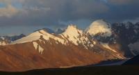
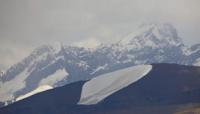
Sights of Maibash-Too Ridge.
“Personally, it seemed to me that we found ourselves in such a jungle, where nature goes to hide from itself, hide from its loneliness, from its decrepitude, from the fatigue of existence. And here she plunges into the memories of her youth, dating back to some era of the Paleozoic era, and, feeling the past touches of the ancient disappeared seas and the giant monsters that inhabit them, becomes alien to the modern world.
N. N. Palgov, In the Central Tien-Shan.
Nature of Maybash-Too mountains.
Maybash-Too ridge is located in the Tien-Shan mountains, east of the breakthrough of the Sarydzhaz River through the Kokshaal-Too ridge, 17 kilometers southeast of the Kaindy-Katta ridge in the Aksuy district of the Issyk-Kul region.
Maybash-Too stretches for 25 kilometers from the southwest to the northeast, has the greatest width in the central part of 17 kilometers. The highest peak of the ridge is Maibashtau Peak, 5361.2 meters above sea level, located in the southern part of the glaciation of the ridge.
The second highest is an unnamed peak with a height of 5192 meters above sea level. The third highest is an unnamed peak with a height of 5192 meters above sea level, located 2.7 kilometers to the west and slightly north of the second peak.
In the Maybash-Too Ridge, three glacial massifs are considered - southern, central and northeastern. The glaciers of the southern massif have western and eastern exposure. The glaciers of the Jamansu river basin are concentrated on the western side of the massif, and the glaciers of the Jonadzher river basin are concentrated on the eastern side.
Glaciers of the Maybash and Sarytor river basins are concentrated on the northeastern side of the massif. In the central part of the massif there are glaciers of the Sarytor and Kirigaily river basins. The longest glacier is Maybash, 3.7 kilometers long, which is located on the northern slope of the ridge and belongs to the Maybash river basin.
From the south, east and northeast, the ridge borders on the northern slopes of the Kokshaal-Too ridge. The watershed between the ridges is the Jonager River, 30 kilometers long. The sources of the river begin from the southern slope of the Maybash pass, 4001.2 meters above sea level, which is located in the northeastern part of the ridge.
The Jonadzher River is the right tributary of the Sarydzhaz and flows into it at the break of the Kokshaal-Too ridge. The Sarydzhaz River borders the ridge from the west. From the north and north-west, the boundary of the ridge is the Kayukan River, which, before the confluence of the left tributary of the Maybash, is called the Terekty.
The Terekty River originates from the Terekty Western glaciers with a length of 8.4 kilometers and the Terekty East with a length of 7.5 kilometers. Both glaciers are located on the northern slope of the Kokshaal-Too ridge.
One of the tributaries of the Terekta River begins with the tongue of the Kayukap glacier, 11.2 kilometers long, which is located in the northeastern part of the Kaindy-Katta ridge.
Geographical coordinates of Maybash-Too Ridge: N41°53'12.55" E79°38'31.44"
Authority and photos by
Alexander Petrov.