


You are here
Ridge Western Kokshaal-Too.
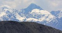
Flight by helicopter in mountains West Kokshal-Too.
“Nature reacts not only to physical disease, but also to moral weakness; when the danger increases, she gives us greater courage”
Johann Wolfgang von Goethe.
Ascensions in ridge Western Kokshal-Too.
The Western Kokshaal-Too ridge is part of the main Kokshaal-Too ridge, located from west to east and further to the northeast, in the southern part of the Kyrgyz Republic in the Naryn region. The ridge is the state border between the Republic of China and the Kyrgyz Republic.
The beginning of the ridge in the west is located at the sources of the Kurumduk and Karabel rivers, which are the left tributaries of the Kekkiyya river belonging to the Aksai river basin. In the west, the ridge is bordered by the eastern end of the Meidantag ridge.
The eastern border of the Western Kokshaal-Too ridge is the Uzengegush River valley, which cuts the Kookshaal-Too ridge from north to southeast. In the north-west and north, the border of the ridge is the river valley: Aksu, Kokshaal, Kotyr and Uzengegush.
In the northwest, the ridge includes the Sarybeles and Keltau mountains and a little north of them the Kekkiyya ridge mountains. The main glaciation of the ridge is concentrated in the eastern part, in the area of the Kyzyl-Asker (Krasnoarmeets) peak, 5842 meters above sea level.
In this area, glaciers flow down from the ridge to the north: Kentor, Karagermes Western and Eastern, Aytali, Sarychat, Grigorieva. The next ice knot is located in the area of Dankov Peak, these are the glaciers: Uzengegush, Chon-Turasu, Researchers, Chon-Tyuskuyruk.
The length of the ridge from west to north-east and east is 206 kilometers. The highest point of the Western Kokshaal-Too ridge is the Dankov peak, 5982.3 meters above sea level, located in the eastern part of the ridge.
The river system of the ridge belongs to the Tarim river basin. There are many vertices here, about 6,000 meters above sea level. The most interesting of them (from west to east): White peak, 5697 meters above sea level, Kosmos peak, 5940 meters above sea level, Molodezhny (Friendship) peak, 5330 meters above sea level, Maron peak, 4902 meters above sea level, Professor Gorelik peak, 4758 meters above sea level, Krylya Sovetov peak, 5800 meters above sea level, Schmidt peak, 5954 meters above sea level, Joldash (Chon-Turasu) peak, 5729 meters above sea level, Alpinist peak, 5641 meters above sea level sea, the peak of Sergei Korolev 5815 meters above sea level.
Of these peaks, in 1969, the ascent was made only to the peak of Sergei Korolev. The ridge is characterized by a combination of typical alpine forms (many steep walls with a height difference of 1.5 - 2 kilometers) with great snow cover and powerful glaciation, which is second only to the glaciation of the Pobeda Peak area in the Tien Shan.
The snow line is located at an altitude of 4000 - 4500 meters above sea level. The valleys of re have a rather high absolute altitude of 3000 - 3500 meters above sea level. In many places, there are wetlands even at an altitude of 3500 - 4000 meters above sea level.
The climate is harsh. In summer in the valleys, the average monthly temperatures are 5 - 8 degrees C, the average monthly precipitation is 20 - 30 mm. The weather is unstable. There is no permanent population south of the Naryn River.
A small part of this area is used as temporary pastures by villages located on the shores of Lake Issyk-Kul and near the Naryn River. In the upper reaches of the Naryn River, geological exploration is being carried out intensively.
The valley of the Uzengegush River is visited only by shepherds and hunters, but there are also expeditions of geologists and geographers. The approaches here along the trails are quite long and difficult. The simplest, but the longest way is from the side of the Naryn city, the shortest, but the most difficult ones are from the Karasai village to the Naryn river.
The most optimal way to the climbing area lies from the village of Karakol through the Sapozhnikov pass.
Geographic coordinates of the Western Kokshaal-Too ridge: N41 ° 03'21.68 "E77 ° 02'59.62"
Authority:
Alexander Petrov.
Defeated peaks. 1968 - 1969. Publishing house "Mysl", Moscow, 1972. "In Western Kokshad-Tau". Korsun A., Povarnin P.
Photos by
Alexander Petrov.