You are here
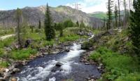
River Arasan.


Kayak trip on Rakhmany lake.
«A lake is the landscape's most beautiful and expressive feature. It is earth's eye; looking into which the beholder measures the depth of his own nature»
Henry David Thoreau.
Packaged tour in Ust-Kamenogorsk and Altay.
The river Arasan has extent from the beginning of sources to a confluence with the Rakhmanovsky lake - 12 kilometers. Throughout 2 kilometers 600 meters the river Arasan flows through the Rakhmanovsky lake. Then the river Arasan follows from the lake Rakhmanovsky and 3 kilometers with frequent meanders flow to the lake Arasan.
In a middle part of the valley of the river Arasan the sanatorium Rakhmanovsky klyuchi which is located at the height of 1760 meters above sea level is located, there are radonic sources. Height difference on the river Arasan from sources from the thin anonymous lake located at the height of 2218 meters above sea level to 1500 meters above sea level at a confluence with Belaya River Berel.
A little more than 600 meters the river Arasan proceed through boggy, with the small island, the lake Arasan (Small Rakhmanovskoye) and through 4 kilometers passing the cascade of falls Usy batyra falls on the left side into river Belaya Berel.
Total length of the river Arasan makes about 20 kilometers. The river Arasan originates from northern slopes of the ridge Southern Altai and the western slopes of Ukok Plateau. The river Arasan is located in the Katon-Karagay Region of East Kazakhstan region in the territory of the Katon-Karagay national natural park.
Authority and photos
Alexander Petrov.


