


![]()
You are here
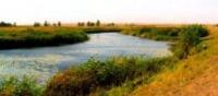
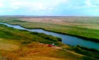
River of Irgiz.
Cognitive trip to Kazakhstan.
“Travel to the best of your ability and free
time, but primarily in their home country
“we still don’t know her properly"
Travel to Ustyurt plateau in Kazakhstan.
The Irgiz river is low-water, originating on the eastern slopes of the Mugalzhar mountains. The total length of the river is 593 km, the catchment area is 31,600 square kilometers. The floodplain is meadow, sandy.
The channel is winding, branched, width 80 - 120 m. The river flows among the sands. Valley 1.3 - 2.0 km wide in some places narrows to 0.3 - 0.5 km. The slopes of the valley are moderate steep, height from 5 to 8 m.
At river Irgiz there is a redistribution of river flow. Part of spring water discharged in a southeast direction to the tract Amankol and then 110 km enters the newly formed channel flowing into the Torgay river. Moreover, significant the amount of water here is bottled in the solonchak tract of Karakug and spent to fill the lakes.
A constant course only in high water, with the onset of summer In some places the flow of the river is interrupted in places and the water is retained only in disconnected reaches. The food is mostly snow. In the upper river, the water is fresh, in summer to downstream it is salted.
The composition of the water in the river is chloride. In spring, the mineralization of water is 0.4 - 0.7 g / l in the middle course, sometimes up to 2.0 g / l - in the lower course. Hardness of water, accordingly, moderately stiff and very stiff. In summer, water reaches the middle section the river contains up to 2.0 g / kg, downstream - up to 4.5 - 5.0 g / kg of soluble salts.
In it time water is not suitable for drinking. The average long-term water flow in the river is 4.0 m3 / s near the village of Doneleksor and 7.56 m3 / s near the village of Irgiz. It freezes in mid-November, the ice thickness reaches 1 m, opens in the first decade of April.
The water level in the spill rises by 4 - 5 m, but already by the end of April flows in their shores. Low water from July to October. The Irgiz river is the main source of water for many points located on its shores. Water is also used for livestock watering, watering gardens and estuary irrigation.
Authority:
Natural resources of Aktobe region. Ecoproject LLP. 216 p.
Photos
Alexander Petrov.