


![]()
You are here
Rock art of Tajikistan.

Rock paintings in Tajikistan.
"Basalt blocks of hash
bent over a stormy river.
On the rocks - from the ocher picture
inscribed with an ancient hand"
Peter Korytko.
Visiting petroglyphs in Tajikistan.
In the 1970’s, about 150 locations of petroglyphs, differing by their number of images and their level of study, were registered in Tajikistan (Ranov 1976).
First knowledge about Tajikistan rock art, in the vicinity of Kalai-Panj village (Pamir), was published in 1879 by the British Captain Henry Trotter (Trotter 1879). A famous work by the Danish explorer O. Olufsen, who visited the Pamirs in 1896 - 1899 and described drawings on rocks near the village of Langarkisht, came out in 1904 (Olufsen 1904: 193 - 196).
Later, information on Tajikistan rock art was published by Bobrinksiy A.A. (1908), Korzhenevskiy N.A., and Ratzek V.I. (Ratzek 1944). The first serious but mostly tentative publications of Tajikistan petroglyphs appeared in the second half of the 1940’s, after mere references in the works of travelers or specialists in other areas. They are credited to to Dalskiy A.-N., Madji A.E., Mandelstam A.M., Bernshtam A.N., Ranov V.A., Zhukov V.A., Gurskiy A.V., Agahanyats O.E., Panfilov O.V. and others.
They provided not only descriptions of rock art locations, but they also tried to date the art, counted the images and photographed them. A series of publications specifically dedicated to Pamir rock art sites, such as Langar and Shakhty, came out in the 1960’s.
Based on its landscape and geographic location, Tajikistan is divided into three zones with a high concentration of rock art monuments:
Eastern and Western (Badakhshan) Pamir,
Gissar-Alai,
Western Fergana
(the Kurama and Mogoltau Mountains) (Bubnova, 2008).
Pamirs are a mountainous region.
Three concentrations of rock art sites in Tajikistan are grouped according to their landscape and geographical location: Eastern and Western (Badakhshan) Pamir; Hissar Alai; Western Fergana (Mounts Kurama and Mogoltau) (Bubnova, 2008).
Pamir is a highland region differently defined. A famous geographer, Agakhanyants O. E. (1965), for example, determines four regions from a combination of physiographical conditions: Kashgar, Central, Hindukush, Vakhan Hindukush, and Western Pamir.
However, Pamir is divided according to the administrative borders of the Gorno-Badakhshan Autonomous Region of the Republic of Tajikistan: in the north along the Alai Range, in the south along the Pamir and Pyandzh rivers, in the east along the Sarykol Range, and in the west along the Darvaz and Khazretishi Ranges.
Geomorphological features differentiate Western Pamir (Badakhshan), with a Mediterranean type of vegetation, from Eastern Pamir, where the vegetation is Central Asian. Western and Eastern Pamir strongly differ from one another according to terrain, climate, and natural settings.
The frontier is marked along the 73rd meridian that stretches from the Lenin Peak south of the Muzkol Range and farther east to the middle of the North Alichur Range along the western shore of Lake Yashilkul and to the Pamir River in the area of the Khargush Pass (Fig. 2) (Bubnova 2008).
Western Pamir (Badakhshan).
It is part of a deeply dissected terrain in a highland that evolved in the Pleistocene as a result of the active denudation at a high altitude, with peaks at 7,000 - 6,000 m. a. s. l. (Ismail Samani. The chapter dedicated to petroglyphs in Pamir has been prepared by Bobomulloev B.S. according to unpublished materials from the private collection of Ranov V.A. archived at the Institute of History, Archeology, and Ethnography of AS of the Republic of Tajikistan.
Research Associate Akhmad Donish Institute of History, Peak: 7,482 m. a. s. l., Karl Marx Peak: 6,726 m. a. s. l., Mayakovskiy Peak: 6,095 m. a. s. l. and others). Separated from the Central Asian deserts, this region shows no loess accumulation under conditions of deep erosion, but only gravitational and alluvial deposits.
The lowest tier of the narrow and deep Badakhshan valleys consists of pebble terraces. This is the center of social life. The most ancient terraces are preserved in fragments as small patches of alluvium “suspended” high above the valley at an altitude of 300 - 700m.
A specific feature of the Badakhshan valleys is steep mountain slopes often covered with a thick layer of scree and altitude differences between the bottoms of valleys and the mountain ranges, aligned mainly from north to south and reaching 3,000-4,000 m. a. s. l.
The steepness of slopes sometimes causes a change in elevation from 500m to 1km. The Badakhshan mountains are considered dry. Annual precipitation in the valleys ranges from 100mm to 20mm and up to 300mm in the west of the region.
In February-March the snow cover reaches 20 - 40cm and stays for about three months. Maximum precipitation occurs from March to May. The summer in the valleys is warm or moderately warm. Temperature changes are significant within a range of 24 hours.
The Badakhshan flora and fauna change significantly depending on the altitude. Differences in the faunal composition of Tien-Shan and Western Pamir are relatively insignificant, while the fauna of the latter is scarcer than that of the former.
Badakhshan people’s lives are, from birth to death, closely related to the mountains, so they have to adjust to these harsh conditions that shape personality and world outlook.
The main prey hunted by Pamir is the mountain goat (Capra sibirica Pallas) or nakhchir in the local language. Markhoors (Capra falconeri Wag.) occur less frequently. Wild sheep or argali (Ovis ammon Linnaeus) may be found on flat surfaces in the area of contact with Eastern Pamir.
Large mammals include a Central Asia subspecies of brown bear (Ursus arctos Linnaeus). According to rock art, Bactrian deer (Cervus elaphus bactrianus) may have lived there up to an altitude of 3,000m. Predators include snow leopards (Felis unica Schreber), black Tibetan wolf (Canis 1 chanko Gray) and red dog (Canis alpinus Pallas).
Smaller predators include fox, otter, and rock marten. Hares are found everywhere. In some plains, valleys are quite wide and have a large flood plain as, for example, Vakhan between the villages of Langar and Namatgut, and are suitable for farming and gardening.
Wheat and barley grow at an altitude of 3,000 - 3,300m and are farmed in addition to potatoes, corn, lentils and other crops.
Eastern Pamir (Pamir Plateau or High Pamir).
Is located where the high ranges of Tien Shan, Kunlun Shan, Karakorum and Hindu Kush meet. This region is the western part of the system of the highest mountains in Asia and offers some of the harshest conditions in the world for humans to live in. External ranges that reach altitudes of 6,000 - 7,000m significantly surpass the mountain ranges located in the internal part of Pamir.
Pamir Highlands.
comprise a system of broad lake beds and river valleys at an altitude of 3,600-4,200m separated by relatively low ranges up to 1,000 - 2,000m severely deteriorated by denudation processes. Pamir is one of the harshest mountain deserts in the world comparable, in this respect, with Tibet.
Its main climate features include high altitude aridity, and an extreme continental climate that causes cold winters with little snow and a short cool summer. The annual temperature range can be as much as 73ºС. Botanists determine these very harsh climatic conditions of the “Roof of the World” as “extreme for living”.
This region represents a western outpost for the Tibetan fauna. Commonly found large animals include Tien-Shan argali (Ovis ammon L.) and mountain goat (Capra sibirica Pal.). A typical Rock Art in Tajikistan 75 domestic animal in Pamir is kutas or yak (Bos mutus P.), which provides highlanders with meat and high quality dairy products.
There are also bears (Ursus arctos L.), wolves (Canis Lupus L. and Canis Cuon Hodgston), snow leopard (Unica unica Sch.), hare (Lepus tolai P.), marmots (Marmota menzbieri К.) and others in the Pamir highlands. Prevailing types of landscapes with rock art in this sub-area; type of substrate for rock art Pamir is the Tajikistan region richest in rock art; more than 50 concentrations of petroglyphs are registered.
No other surrounding highland region such as Svat, Gilgit, Khunza, Ladak, Tibet or Afghanistan can boast of such quantity and diversity. There, as in Pamir, most sites are concentrated along the valleys of major rivers, since human activity has always been linked to valleys, while mountainous or taiga areas were barely ever used.
A glance at the petroglyph map of Pamir will convince one that a major accumulation of petroglyphs is tied to the Pyandzh River and its main tributaries; quite a few are found in Yazgulem and Gunt. Concentration of sites in this area resulted from the fact that a narrow strip of valley suitable for agriculture, which Pamirians intensively used for all their activities, stretches along the foothills of high mountains.
Other concentrations of petroglyphs, such as Vybistdara, are located in traditional summertime areas for cattle grazing and the processing of dairy products. Locations with few images are found in the upper reaches of rivers, i.e. mountain passes (Abdukagor, Dzhamak, Koytezek, Aktash) or where tributaries join larger rivers (Darsay).
Quite often large boulders or vertical rock surfaces polished by the sun and wind caught the attention of people with artistic abilities as if urging them to leave a kind of message on their surfaces (Namatgut, Dzhamak petroglyphs). Known concentrations are related to ancient caravan routes or to most remarkable places (Langar).
Many images are found on low terraces near old or still existing roads, burial sites, fortresses, the ruins of ancient settlements, and along lakeshores. Many petroglyphs were made in places renowned as hunting grounds; in Langar, for instance, piles of stones are used as a refuge for hunters.
At the same time, no strong links of petroglyphs were noted with modern sacred places, most passes or known springs (Fig. 3) (Bubnova 2008: 36). In Eastern Pamir, all petroglyphs are found near ancient burials (paintings in rock shelters at Shakhty, Kurtek, and Nayztash).
In Western Pamir.
Rock art was registered at an altitude of 3,500m, and at an altitude of 4,200m in Eastern Pamir. It is difficult to pinpoint other patterns of petroglyph locations in Pamir, since they are tied to the different landscapes of this mountainous region.
Images were engraved on isolated stones (more often on water-worn boulders, sometimes on their debris) or on large rock faces, vertical and horizontal.
It is difficult to determine patterns in the arrangement of images on rock surfaces with different expositions. Quantity and Distribution of Rock Art Sites in the Sub-Area The total number of images is over 10,000.
According to quantity of their petroglyphs in Tajikistan, sites can be divided into three groups:
1). Those with more than 1,000 or several thousands of images (Bybistdara: 1,200, Langar: 6,000);
2). Sites with no more than 100-200 images (Akdzhilga, Darshay, Salymulla);
3). Sites with 10 - 20 petroglyphs or even single petroglyphs (Kukhilal, Tamdy, and others).
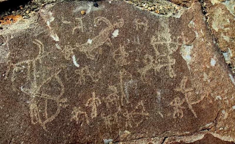
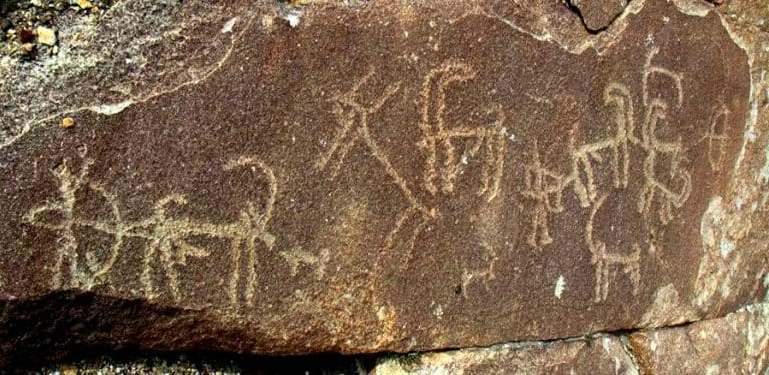
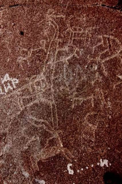
Sites of the third group are the most numerous. Large locations of petroglyphs are true picture galleries, with compositions and sometimes tens, hundreds, or even thousands of similar petroglyphs that preserve for the future the ancient ideas, beliefs and traditions of the people who inhabited the lands or found a temporary abode there, when moving from one place to another.
The Shakhty grotto paintings are the most ancient in Pamir. Ranov V.A. dates them, from the discoveries of stone flints, to the Mesolithic – Early Neolithic (VIIIth - Vth millennia BC). Apparently, the Shakhty grotto paintings are related to a culture found at the highest altitude - the Markansui culture.
Paintings were also found two kilometers away from the Shakhty grotto under an overhang (Kurteke) and 15km away near the Nayzatash pass, both attributed to the Neolithic. The listed sites dated to the Stone Age are located within the same area in Pamir at a small distance from one another.
Nevertheless, the three sites completely differ in technique and style, so they, apparently, must differ in time. Akdzhiga rock art is made using a specific technique on an open surface and is dated to the Bronze and Early Iron Ages. The numerous petroglyphs of such large sites as Langar and Vybistdara have a wide chronological range, from the Bronze Age to the 1st millennium BC to the XVIIth – XXth centuries and modernity. Most other sites contain images of different periods, the most ancient dating to the Bronze Age.
Archeological Context of this Sub-Area (Brief Description, Level of Study of Archeological Cultures Relevant to Identified Traditions of Rock Art) Despite weather conditions that made human adaptation in the highlands difficult, Pamir was peopled long ago.
Markansu archeologists discovered and excavated Mesolithic sites with a well preserved occupation level. This is the highest site in the world; according to radiocarbon dating, it is 9,530 ± 130BP years old. A total of 63 sites with Stone Age evidence were registered in Pamir including some in caves and rock art sites.
Most relate to the Markansui culture (VIIIth – Vth millennia BC), which manifests similarities with contemporary cultures in Siberia, Transbaikalia, and, probably, north-western China. Pamirian sites of later periods – Neolithic and Eneolithic (Chalcolithic) - are less known, probably because of climatic deterioration.
Bronze Age evidence is also rare: only 5 - 6 isolated sites. Conversely, the subsequent Saki period is well-represented by numerous kurgans. The main researcher of sites of that period, Litvinskiy B.A., reports data on more than 50 Saki burial sites and individual kurgans and estimates the population of Pamir in the 1st millennium BC to be about 10,000 - 15,000 people.
The latest research showed that in Pamir, sites of the Early Iron Age, the Middle Ages and modernity are the most numerous (Fig. 5) (Bubnova 2008: 38). Sites of different historic periods are unequally represented in Pamir due to the significant climatic variations during the Holocene.
It is difficult to imagine the existence of Mesolithic tribes under the current climatic conditions of Pamir. It is suggested that the Pamir Plateau experienced a significant and rapid tectonic upheaval, the amplitude of which amounted to 500 - 600m, within the last 10,000 years.
The upheaval of mountains surrounding the Pamir Plateau aggravated cooling and arid conditions. Back in the Saki period (VIIIth - IIIrd centuries BC), the vegetation cover of the steppe was richer and the Pamir climate was more moderate and favorable (Sidorov 1979).
This is indicated by the spread of kurgans in regions that have no water sources now. The eventual desertification of Pamir occurred at the end of the 1st millennium BC and triggered a rapid reduction in the number of archeological sites in this Central Asian region.
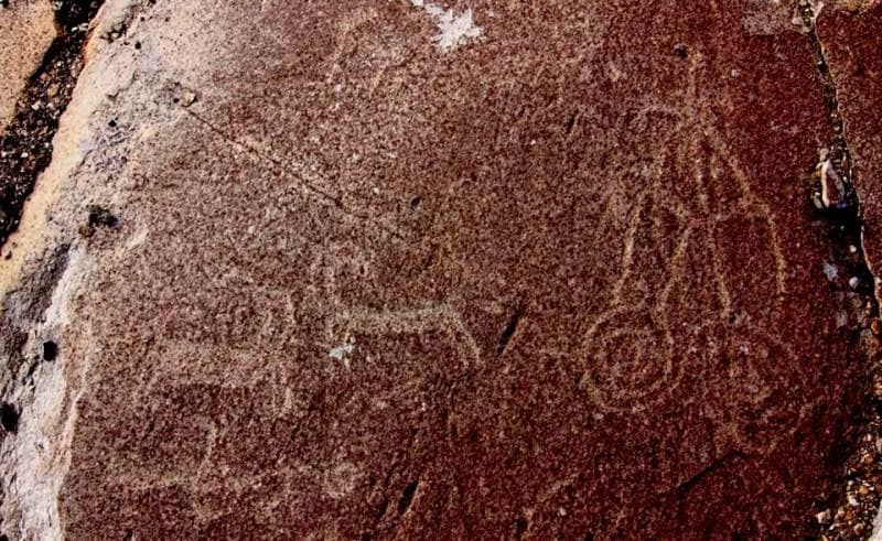
Modern Ethno-Cultural Context of Rock Art Sites; Availability or Absence of Registered Tradition of Worship and Reverence Related to Rock Art Sites In Pamir, most petroglyphs have secular rather than religious motifs: hunting and battle scenes, pets, mythical or, probably, real heroes.
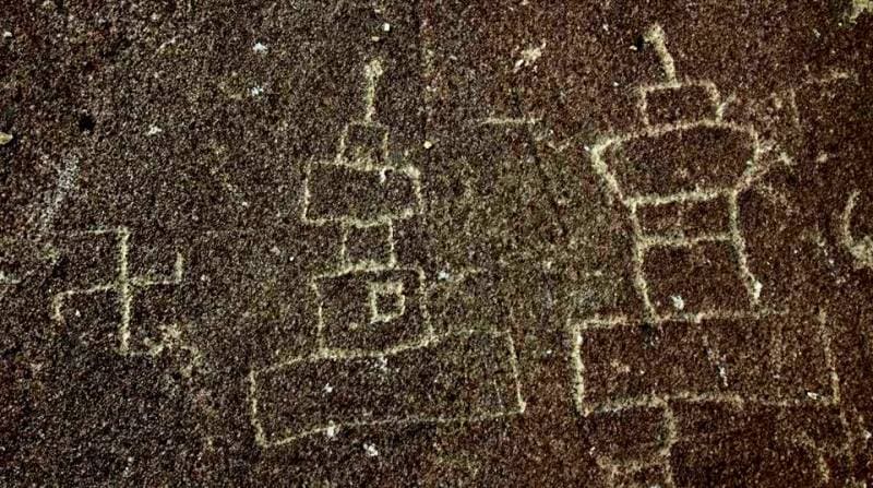
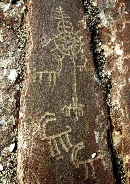
Religious notions, antique mythologies and the routine life of mountain-dwellers – farmer, pastoralist, and hunter– quaintly intertwine. Nevertheless, most petroglyphs reflect day-to-day life, rather than people’s religious ideas. Rock art containing an obviously religious content includes images of an open palm (palm with five fingers – a symbol of Ismaili).
Images of an open palm were registered on several Pamir petroglyph sites. Detailed drawings are quite often found among later images at Vybistdara. At present, the local population pays a special attention to palm images rather than worshipping them.
Authority:
Bobomullo S. Bobomulloev.
Photos by:
Surat Toymasov.