


![]()
You are here
Sights of Pamir Lake Karakul.
Tours, Travel, Holidays in Tajikistan.
"Travel helps to understand the beauty of space and the pricelessness of time"
Gilbert Keith Chesterton.
Unique travels across Tajikistan.
Back in the middle of the XIXth century, Europeans knew about this lake only by hearsay. It was identified with the mythical "lake of dragons" located somewhere in the sky-high heights of the Pamirs. Only in 1876 the military scientific expedition of M.D.Skobelev delivered the first reliable information about the lake.
Soon, these data were expanded by other expeditions, in particular by the geologist I.V. Mushketov in 1877 and the zoologist N.A. Severtsov in 1878. The relay race for exploring the lake and its surroundings continues to this day.
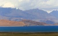
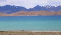
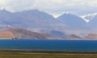
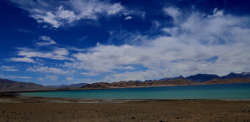
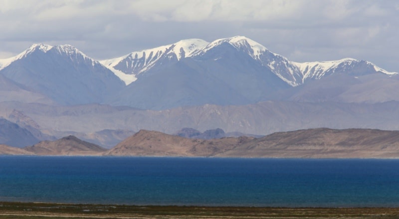
When you go along the road, the view of the lake opens up from the Uy-Bulak stream. Repentant at an altitude of 3914.5 meters above sea level, it sparkles with thick blue waters at the bottom of a huge mountain basin.
The reservoir seems to emit a bluish light that hides the contrasts in the drawing of the surrounding mountains, at the same time clearly highlighting the contours of the ridges. The lake is somewhat elongated from north to south.
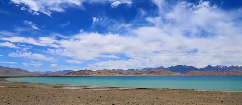
From the west, the slopes of the ridge break off into it, and from other sides lifeless sandy-gravelly shores adjoin it, reinforcing the impression of pristine nature. The lake turned out to be the largest on the Pamir and one of the highest-lying large bodies of water in the world. It was found that it has long had its own name - "Karakul" ("Black Lake"), given for the dark color of the water.
A number of interesting features emerged in the basin with the lake. For example, the harsh climate of a high-mountainous desert with sharp changes in daily temperatures dominates here, and in some places even deposits of fossil ice are discovered shallow underground.
There is only 70 mm of precipitation per year. that is, less than in the Karakum Desert. Despite this, about 20 kilometers of cubic water accumulated in the lake from small and large streams escaping from the surrounding mountains.
The lake has no runoff, and therefore the water in it is brackish-bitter, the greatest depth exceeds 230 meters. Some researchers believed that the inflow of water was insufficient to maintain the level of the lake. Doubts, however, disappeared when they found that the lake is largely fed by still powerful sources of groundwater erupting from the bottom of the lake from underwater craters up to 10 meters in diameter.
Moreover, the water in the lake has clearly increased.
Already in the 30s, the rising water cut off the northern peninsula from the coast, which has now become an island. The famous Pamir explorer N.L. Korzhenevsky, who visited the lake in 1903, 1923 and 1935, saw that peninsula and the already formed island.
In general, it turned out that the vicinity of the lake is characterized by an abundance of groundwater, the outlets of which were noted in many places of the basin. The latter look most impressive in winter. The water coming from the springs forms extensive ice, in the center of which ice mounds grow.
Acting like a volcano, they pour out water, which immediately freezes on the slopes of cones, reaching large sizes. One of the most interesting places in the basin is the wide valley of the Muzkol River, which flows into the lake from the south.
The valley of this river, formed near the Suok-Chubyr tract by the confluence of the Kizil-Dzhiik and Ak-baital rivers, is remarkable for the fact that not long ago, all year round, a layer of ice up to 2 meters thick, which melted in 1920, lay in it all year round.
Now here only in winter there is a picture of an ice field from numerous extensive icings. The former eternal ice, presumably, gave birth to the name of the river Muzkol, meaning "ice valley". The extreme severity of the climate in the valley is one of the reasons for the emergence of large ice hills above underground water sources.
Sven Gedine, who stayed in the Suok-Chubyr tract in 1894, only near his parking lot recorded hillocks 5 and 8 meters high. Then they explained to him that the name of the tract means "cold Sibir", since there are often severe frosts similar to Siberian ones.
The translation looks naive: in it, first of all, it is difficult to perceive "chubyr" as "Sibir". A more accurate translation can probably be obtained based on the Kyrgyz language widespread in these places, in which there is a similar sounding word "chybyr" ("mound, hilly locality").
In this case, the first part of the name can be quite confidently understood as the merged words "su" ("water") and "ok * (" white "). Then the translation of the name of the tract is folded in the form "water - white mounds".
It informs that here the water of the springs, freezing, turns into white hills. In the tract, quite a few ice hills are actually formed, often large in size. Unusual hills have become a landmark of the tract, where, moreover, for a long time the paths north - south and west - east converged.
All this fully explains the reason for the origin of the name of the tract. The basin of the lake is vast and stretches to the southwest in the form of a narrowing flat plain with separate lakes. Here it is locked by a ridge that gradually rises about 60 meters above the level of the lake, on the other side of which flows the river Kokuy Bel, which belongs to the Panj basin.
Geologists have determined that it was here in a relatively recent geological epoch that Lake Karakul had a runoff into Kokuybel. Looking at the flat basin of the lake and the barrier that closes it, one involuntarily thinks that, if need be, it is possible to revive the old lake drain by artificial means without any particular difficulties.
That is why it could be useful: a small water withdrawal that does not violate the local ecology could contribute to the desalination of the lake. On the other hand, this would add at least a small measure of the water of the Amu Darya, from which now little reaches the drying Aral Sea.
Perhaps all this will happen in the future. As for the dragons, they were not found either in the lake or in the area. The lake itself turned out to be lifeless. On land, marmots, voles, hamsters, small herds of argali were found, descending into the hollow from the slopes of the mountains.
There were especially a lot of hares, which in due time gave rise, as N. L. Korzhenevsky notes, to call the basin of Lake Karakul “Pamiri Khargush” (“Hare Pamir”). It must be assumed that good-natured animals were not the reason for the legend of dragons.
Since then, there have been fewer hares here. But occasionally their number increases greatly, even acquiring the character of an invasion. Judging by the name "Hare Pamir", in the previous years the invasions of hares took place here quite often.
The Bash-Kuruk-Sai river ("the beginning of dry san *"), flowing from the slopes to the dividing ridge, also suggests such a reflection. She also has a second name - "Kuyandy" ("Hare", from the Kyrgyz "koyon" - "hare").
According to N.L.Korzhenevsky's remarks, this river flowed into Kokuybel back in 1880, and in 1923 it was already divided into two streams, one of which still flowed into Kokuybel, and the second turned into the basin towards lake Kurukkul ("dry lake").
It can be seen that the valleys of Kuyanda and Kokuybel where there is much more greenery and fodder, and are a gathering of hares. But now there are more and more pastoralists with their herds. The eared ones are clearly getting tight, and from time to time they turn along the water into a hollow
There is, however, a curious moment in this hare story: the lake basin is named with the word "Pamir", which is used to name the border river of the south of Tajikistan and the highest mountainous country in the USSR, and the meaning of the word weight is still unclear.
One can only hope that the hare name of the cauldron will somehow help clarify the issue. A small village has now grown near the lake, in which road workers, a geologist, a meteorologist, and a hydrologist live and work.
Border guards immediately carry out their difficult service. Nearby, descending from the Uy-Bulak pass, the Pamir tract rushes south. On the way, one after another, views of the wide flat valleys, joining the basin of the lake, open up.
Everywhere there is space and expanse. The mountains that have receded far away look low and rounded. As if this is happening in the foothills, and not in the center of a huge mountainous country. But this impression is deceiving: there are already more than 4 kilometers in height.
The tract crosses the Muzkol river over a bridge and enters the Suok-Chubyr tract. Here, a motor road departs from it to the west, which, following the ancient path, along the line of the former discharge of the lake, leads to the valley of the Kokuybel, Tanymay and Bartang rivers.
The path itself, imperceptibly gaining height, goes to its highest point - the Akbaital pass.
Geographic coordinates of Karakul Lake: N39 ° 02'26.35 "E73 ° 23'40.67"


Authority:
S. Alimov. "The Pamir Highway: A Journey into the World of Names." Almanac "Wind of wanderings", №23
Photos by
Alexander Petrov.