


![]()
You are here
Southwestern Turkmenistan.
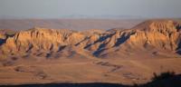
Mountains and deserts of Southwestern Turkmenistan.
"I am a slave of love, a Gauquelin from Atrek,
I'm looking for an enchantress.
A teacher in the wilderness of the century,
I'm looking for a gift of peace."
"Seeking salvation." Translation. A. Tarkovsky. Makhtumkuli.
Sights of Balkan velayat.
South-Western Turkmenistan (Caspian), is located at elevations from - 27 to + 100 - +150 meters above sea level. It is characterized by a complex of vast lowlands diverse in natural conditions, enclosed between the coast of the Caspian Sea in the west, the mountains of the Big and Small Balkhan in the north, the spurs of the Kopetdag in the east and the Atrek valley in the south.
The territory of Southwestern Turkmenistan is located within the southwestern part of the Balkanabat velayat. In general, this is a completely flat plain, slightly inclined towards the sea, with significant massifs of sands - Primorsky Kyzylkum and Seyunagsak sands.
It is composed mainly of tertiary and quaternary marine deposits with a total thickness of up to 5-6 kilometers, and in the eastern part, near the mountains - alluvial-proluvial sediments. The significant thickness of precipitation is explained by the fact that the plain of Southwestern Turkmenistan is located within the vast South Caspian tectonic depression, which experienced a long subsidence.
The modern relief of Southwestern Turkmenistan was formed mainly during the late Pleistocene and Holocene, with the main role played by exogenous processes, which resulted in the formation of uneven-aged alluvial-deltaic plains, proluvial sloping piedmont plains, sea flat solonchak surfaces, coastal sand and pebble swells, sand spits and depressions, eolian sandy massifs with deeply dissected relief.
According to the nature of the relief, South-Western Turkmenistan is divided into 2 parts - northern and southern. The northern, smaller part is located in the zone of the Balkhan tectonic uplifts and the Kyzylkum trough. It includes: the piedmont plains of the Greater and Lesser Balkhans, the system of the lower reaches of the Uzboy.
Kelkor solonchaks and other solonchak basins periodically flooded by the waters of the Uzboy and the Caspian Sea, the Aktale channel, on the site of which the strait between the Caspian Sea and Kelkor passed, the Balkhansky saline land, which emerged from under the level of the Caspian Sea in the mid-1930s, an array of deeply dissected sands of the Dard-jo-Darjakumy peninsula.
Cheleken peninsula, only in the 1930s connected with land, the sands of the Primorsky Kyzylkum, formed by interweaving the alluvium of the great-Amu Darya, the Boyadag-Gyaurly solonchak with the dry bed of the Gyaurli. The richest deposits of gas and some other minerals are located in this territory.
In the southern part, there are: the foothills of the Western Kopetdag, the piedmont proluvial plains of the Western Kopetdag, the sands of Meshedkuma and Masha, the array of ridged sands of Seyunagsak, the coastal saline land lowland, the system of ancient, low-water, and modern deltaic plains and the Atrek valley, among which the largest in area are the modern Gasankuli, young Karadzhi-Batyr, ancient delta Misrian and Chat.
Geographic coordinates of Southwestern Turkmenistan: N38°54'38 E54°39'50
Authority
http://www.caspianmonitoring.ru/
Photos by:
Alexander Petrov.