


![]()
You are here
Tamgalytas near Lake Tamgalynura.
Travel internationally in Kazakhstan.
“Books are the plane, and the train, and the road. They are the destination, and the journey. They are home”
Anna Quindlen,
Go on a journey to Shymkent.
The site is in the Sozak District of the Southern Kazakhstan Region in the north-western end of the Betpak-Dala desert, on the southern bank of salt Lake Tamgalynura, on the left bank of the channel Sarysi–Boktyrkaryn River.
The first reports about Tamgalytash and its images and inscriptions date to the late XIXth - early XXth century. The map of the Western Siberian military district (1896) indicates a “stone Tamgaly-Tash” on the southern bank of salt Lake Tamgaly-Tuz on a highland (Tamgaly-Dzhar Gorge); a more detailed map of the same site (1920) (Р.XIV.L.8) indicates stone Tamgaly-Tash on the left slope of an erosion valley where Tamgaly Spring is shown at the mouth of the valley.
When information was collected for military topographic maps, ethnographic information about images on the rock and their meaning for the evaluation of the Kazakhs along the Sarysu River was also collected. Rock Art in Central Asia 30 In 1895, an interpreter (Khasan Bekhodzhin) who accompanied a military doctor from Akmolinsk town, Kuznetsov A.I., photographed and sketched signs on the Tamgalytas boulder and translated some inscriptions (Kuznetsov 1927: 123).
In 1936, the geologist Satpaev K.I. explored Tamgalytas (1941: 69). In 1946, Margulan A.H. explored the site and distorted the interpretation of an inscription translated by Bekhodzhin Kh. in order to draw a false historical conclusion about the origin of the site as if it related to the unification of Kazakh tribes and the proclamation of the Kazakh Khanate in the XVth century (Margulan & Ageeva 1948: 131; Margulan 1997: 36 - 37; Margulan 2003, Fig. 361).
His statement that “there are names of Ak-Orda khans Urus-Khan, Kuyichirk Barak and many others among the inscriptions” is also unreliable (Margulan 1997: 36 - 37). In 2009, an expedition from KazSRI-Nomads (Rogozhinskiy A.E.) made an inventory of the petroglyphs and photographed all the known surfaces; one more petroglyph site was identified near the Tamalytas boulder.
A Kazakh necropolis consisting of 20 burial structures of different types and different state of preservation is found on the terrace near the Tamgalytas boulder. There is a stone slab with an epitaph (a symbol of faith) and a tamga represented as two parallel lines on one of the mounds.
The inscription dates to the late XIXth century. Neolithic stone artifacts were found on several sites along the shoreline terrace of the lake. Typology and Dating. The site is located on the southern shore of Lake Tamgalynur, in Tamgalydzhar Gorge.
The shoreline terrace is cut across by many erosion valleys, with Tamgaly Spring located in one of them; several isolated outcrops of sandstone are above the spring along 200km on the left side of a small ravine.
The loose substrate lends itself to handling and destruction; the rock surfaces are coarse, reddish-brown, covered with dark-brown and black patina (“desert patina”) in some places. The largest number of ancient signs and inscriptions were found on a sandstone outcrop, a remnant of “Tamgalytas stone”, closest to the spring.
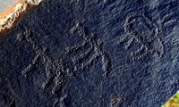
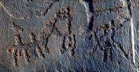
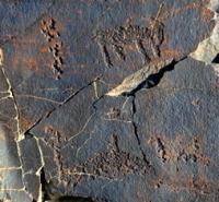
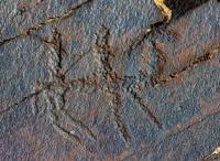
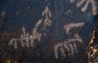
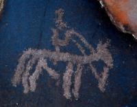
Higher along the dry riverbed, there are three more large sandstone outcrops with a large number of inscriptions and signs. Three temporally different groups of petroglyphs can be made out: ancient tamgas without accompanying epigraphy; Arabic inscriptions, sometimes accompanied by tamgas; Cyrillic inscriptions-graffiti of the XXth century.
The earliest tamgas are deeply (up to 0.5 - 2.0 cm) abraded and hammered into surfaces and fragments of Tamgalytas 1 and 3. A sign consisting of two or three parallel lines frequently occurs; others are sporadic.
Matching these tamgas with those of Oguz and Kipchak people suggests a date of origin for the first Tamgalytas images within the VIIIth - XIIth centuries. The second period at the site is that of the early Tamgalytas epigraphy; Beysenbiev T.K. who studied several inscriptions dates them to the end of the XIXth century.
Some tamgas of different Kazakh tribes from the Minor and Middle Zhuses are dated to the same period. The final stage of the site’s history, judging by the dates of visitor’s inscriptions, covers a period of time from the 1930’s to the 1990’s.
There is another small group of boulders with tamgas located 1.2km to the south-east of Tamgalytas on the right slope of the erosion valley. One slab was used to build the Tamgalytas site erected recently at the edge of the terrace.
A total of 10 varieties of these signs are comparable to tamgas of the medieval period identified within the main location of Tamgalytas.
Authority:
“Rock Art Sites in Kazakhstan”. Alexey E. Rogozhinskiy.
Photo by
Alexander Petrov.