


![]()
You are here
Ustyurt Plateau.


Tours on plateau Ustyurt.
“When Nature has work to be done, she creates a genius to do it”
Ralph Waldo Emerson.
Plateau Ustyurt Travels.
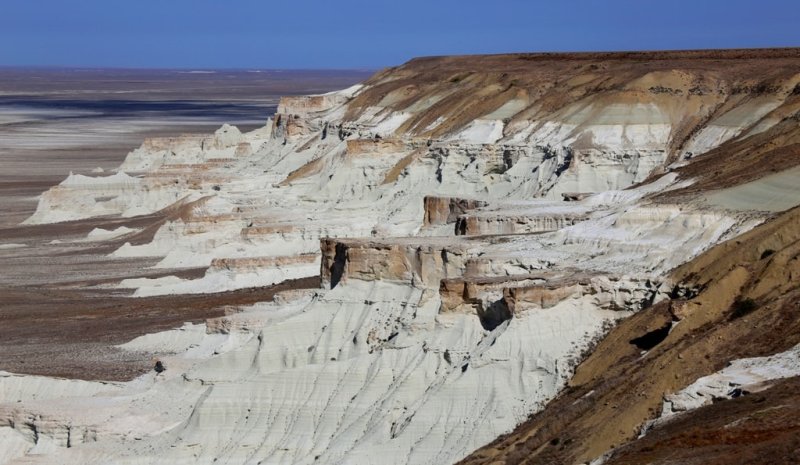
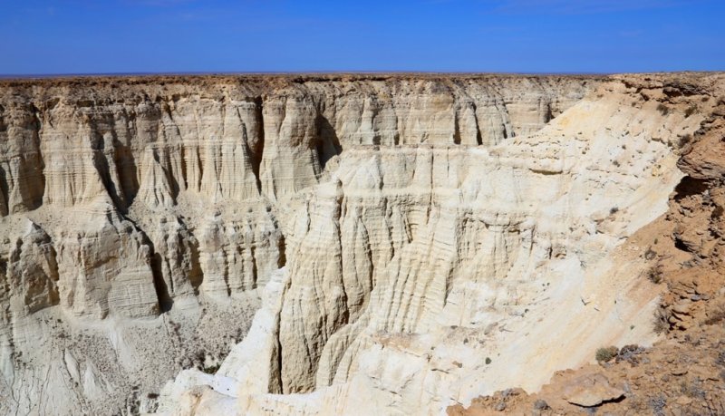
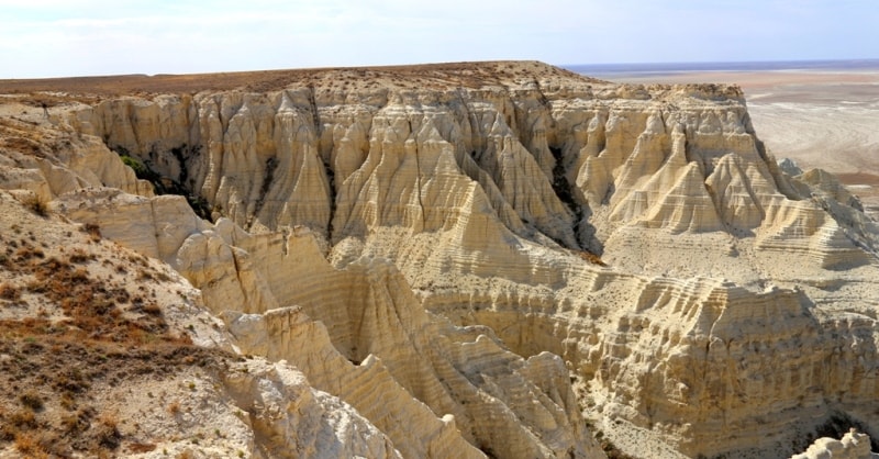
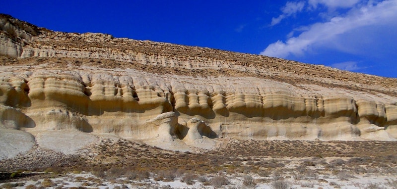
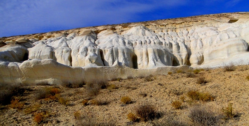
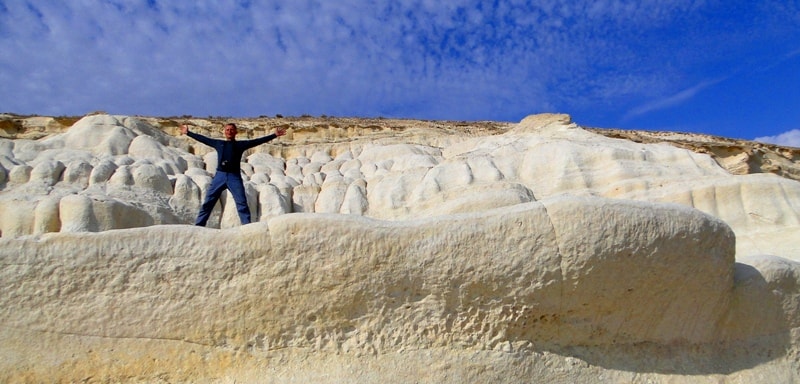
Plateau Ustyurt is almost the perfect desert plain located in western Kazakhstan between the Aral and Caspian Seas. The steep slopes, limiting the plateau - chinks - give the unique beauty to the landscape. Especially picturesque is the western chink which height reaches 340 meters.
Ustyurt is the largest geomorphological element of earth’s surface, which like the Great Barrier Reef is clearly visible from space. However, by its nature and the mysterious geological history Ustyurt is much more interesting than the famous Australian structure.
The total length of the chink chain is several hundred kilometers, which makes it possible to create here a family of Geoparks. However, presently, as the first stage for the development of geo-tourism only relatively small (100 km) segment of the Western chink of the Ustyurt, located within the reserve of the same name, can be considered. Ustyurt State Nature Reserve, located in Mangistau region, occupies the western part of the Ustyurt chink, a narrow pre-chink strip of the plateau and vast Kendirlisor lowering.
The area of the reserve is over 223 000 hectares. Reserve was set on 12 July 1984 by the Decree number 294 of the Council of Ministers of Kazakh SSR in order to preserve the natural state of the natural complex of northern deserts of Ustyurt Plateau, including some rare species of fauna and flora.
Flora of Ustyurt includes about 600 species of higher vascular plants. It is inhabited by a large number of invertebrates, reptiles, birds and 44 species of mammals: rodents, lagomorphs, carnivores, artiodactyls, insectivores, bats.
Some of them are entered into the Red Data Book: Four-stripes runner, houbara (houbara bustard), serpant eagle, long-legged buzzard, saker falcon, cheetah, caracal, sand cat, manul, Ustyurt mouflon, antelope, gazelle, etc. In ancient times the plateau was crossed by the old caravan routes, including the Great Silk Road, and the ruins of the caravan-sheds, ancient towns and fortresses remind of this.
Across the plateau the old cemeteries with majestic mausoleums – Mazarin are scattered. Ustyurt knows about 60 Neolithic sites. The studied block of the earth crust including Mangistau mountains, south-western parts of Ustyurt and their frame, passed complex and long geological history, which is studied far from complete, but fairly certain answers were received for many questions.
Permian (the oldest) deposits were studied in the mountains of Karamaya, extending along the southern chink of the Ustyurt among sors of Karynzharyk depression. These are crumpled into the folds sandstone, siltstone and mudstone, the color of which varies from black, dark gray and grayish-pink to vine red. Here are found the fossils of terrestrial plants, as well as limestone, marked by wave-cut signs.
In the Permian (250 - 300 million years ago) within modern Mangistau and Ustyurt were settled areas of the shelf seas, lagoons and slightly hilly coastal plains adjacent to the north to the Paleotethys ocean, at that time divided the Arabian-African and Eurasian continents (or rather their predecessors which bear the names of Gondwana and Laurasia). These conditions were preserved also in the Triassic (200 - 250 millions years ago).
At the end of the Triassic the great tectonic movements occurred that led to the closure of the Paleotethys ocean and the entire territory has experienced drainage, and Permian and Triassic strata have been folded into steep folds.
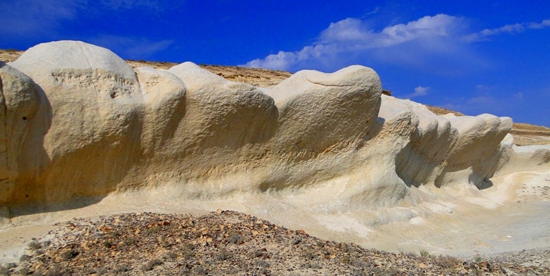
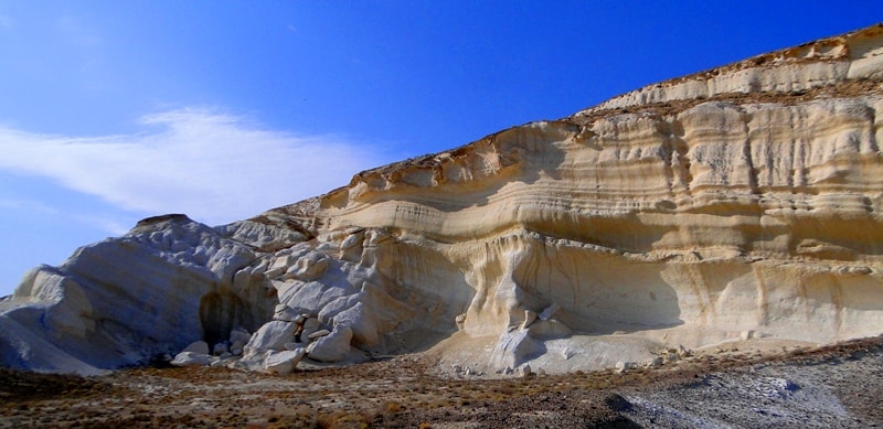
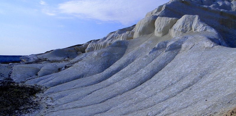
All subsequent deposits since the Middle of Jurassic are characterized by calmer structures: their layers are nearly horizontal or very gently. Further geological history is a alternation of transgressions and regressions of the sea (offensive and retreat), resulting in a powerful platform mantle formation, consisting of differently colored (from pink and blue to blinding white) sediments.
The Jurassic period is characterized by the formation of coal-bearing strata, and the Cretaceous - by the presence of phosphorite nodule and large spherical and disc-shaped concretions of sandstone up to 3 meters in diameter. At the end of the Cretaceous there was a very important global event related, as believed, to the outer space disaster. In the area of the distant Gulf of Mexico the large asteroid collided with the Earth.
The consequences of this collision are well represented in many marine sediments around the globe, including some areas of the Mangistau and Ustyurt. It was here the famous Iridium horizon was defined in the USSR for the first time - a layer of clay of 10 - 20 cm thick, extremely rich in iridium - a metal, many meteorites are saturated with. The energy released in the fall of the Mexican asteroid, estimated to be equivalent to several hundreds of millions of hydrogen bombs.
The earth was plunged into darkness. The sudden environmental catastrophe was disastrous for many organisms, but especially for the dinosaurs. The remains of these reptiles, which are abundant in the sections of the continental Cretaceous, completely absent in the upper layers of the Paleogene. For deposits of the Paleogene (23 - 65 million years) the presence of thick greenish- and bluish-gray clay including numerous fish fossils is remarkable.
“Fish layers” also contain iron sulfides with industrial concentrations of rare earth elements, uranium, scandium, rhenium, nickel, cobalt, molybdenum and other elements. In carbonate-clayey rocks of the Neogene (1 - 23 million years) sulphates - gypsum and anhydrite - are distributed. The carbonate-clay stratum is re-covered by limestone, marl and coquina layers of the Sarmatian, which compose the surface of Ustyurt.
Sarmatian limestone is well familiar to citizens pink and light yellow lining that adorns the fronts of many houses. At Ustyurt the layer of this limestone covers the whole surface as a durable coating that is easy to pass water. Therefore, the plateau is always dry. Even with very heavy rains the water flows are never formed, no rill and gully occur. Most recently, it became possible to solve in a new way the nature of the borders plateau - chinks.
Study of satellite images in the thermal (infrared) range revealed that along these steeps zones of elevated temperatures are stretched. The broken line of positive termoanomalies fully coincides with the western boundary of the plateau. Obviously, that sors, regularly stretching near the foot of the chinks, are connected with deep sulfate-chloride potassium-natron thermal waters, an example of which may be spring Unere and well Edilbay.
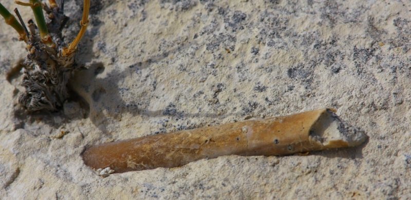
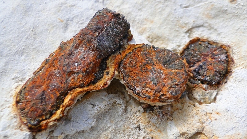
Among the geological attractions of Ustyurt could be mentioned mountains Karamaya, Paleogene remains Three Brothers, gorges Kokosem, Mamedkazgan and Atzhol, Cretaceous sandstone strata with multiple concretions, rich burials of ancient organisms, including ammonites, belemnites, various pelecypods (oysters, inoceramus and etc.), as well as gastropods, brachiopods, corals, sponges, sea urchins and lilies, the teeth of sharks and other fishes.
Unusual geological structure, scenic steeps, the opportunity to travel on wheeled yachts - all these.
Geographic coordinates of the Ustyurt plateau in Kazakhstan: N44 ° 10'50.33 "E55 ° 45'55.41"
Authority:
Ilya Fishman, Yuliya Kazakova “Millions of years before the Silk Road. Geoparks in Kazakhstan”. Printing house “Idan“ Kommunal’naya, 39, Almaty, Kazakhstan http://yadi.sk/d/4_6z_blyoxnqe
Photos by
Alexander Petrov.