


![]()
You are here
Walk to lake Ala-Kel.


Excursions in gorges of Terskey Ala-Too.
“Like all great travelers, I have seen more than I remember, and I remember more than I have seen.”
Benjamin Disraeli.
Trip to Karakol gorge.
Short description of walking route to alpine lake Kel-Suu in Terskey Ala-Too mountains:
Town of Karakol - river and gorge of Karakol - valley "Sirota" - river and lake Ala-Kel.
Distance of tour: (25 + 25) = 50 km.
Season: from July 10 to September 1.
Tour duration: 3 days
Distance of active part of tour: 14 km
Best time to visit: July - August.
Detailed program of excursion walk from town of Karakol to Karakol Gorge:
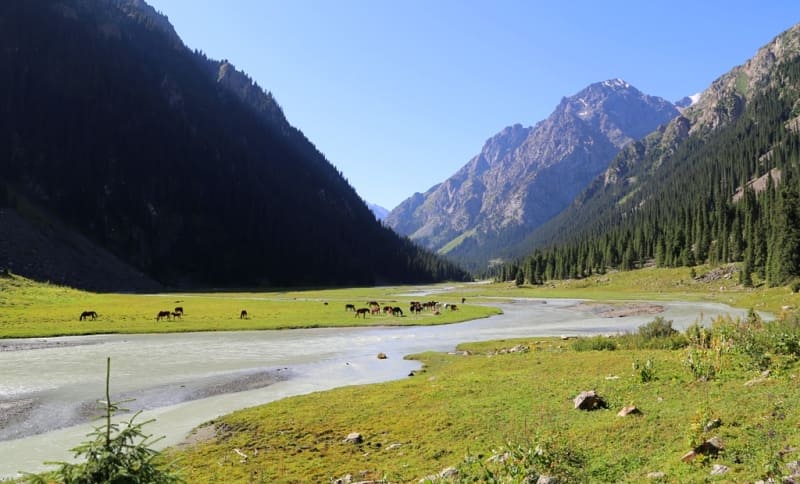
Day 1. Karakol town - Karakol gorge - mouth of river Aitor (25 km).
We leave the city to the Karakol Gorge along Masaliev Street, on which there are many guest houses and hotels on both sides of the street. Our path lies to the south, we pass the city hippodrome, the town thermal power station, soon behind the last houses of the city's residential area there is an ecological post of the Karakol Natural Park.
The road is laid on the right side of the river, soon the Kashkasu gorge adjoins on the left in the upper part, which, at an altitude of 2300 meters above sea level, is the Karakol ski base. In the uppermost part of the Kashkasu gorge, on the northeastern slope, there is a glacier that starts from the Przhevalsky peak, 4271.9 meters above sea level.
After 4 kilometers after the right mouth of Kashkasu, we cross the bridge to the left bank of the Karkol River. Soon, after 1.8 kilometers we overcome a small left tributary - the Zyndabulak River, 3.8 kilometers long, which originates from the northern slope of the Atdzhailau peak, 3689.3 meters high above sea level.
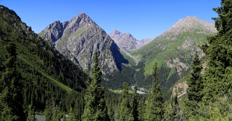
From here begins a difficult and difficult road. After 8 kilometers we overcome the ford through the left tributary of the Aytor, 4 kilometers long, which originates from the northern slope of the Ayutor peak, 4320 meters high above sea level.
In the upper reaches of the Ayutor gorge on the western ridge there are several peaks: Mendeleevets with a height of 4182 meters above sea level, Heroes of Krasnodon with a height of 4215 meters above sea level, Students with a height of 4202 meters above sea level, GERO with a height of 4228 meters above sea level, GTO with a height of 4245 meters above sea level sea, Gastello with a height of 4350 meters above sea level.
On the beautiful and picturesque glades on the right side of the Aitor River, we will set up our camp tents (2546 meters above sea level). Walks in the vicinity of the former camp of climbers. From here, in ancient times, climbers began climbing the peaks located in the upper reaches of the Karakol gorge. Dinner, overnight.
Day 2 Karakol gorge - Ala-Kel lake river (25 km).
Early breakfast. Hiking: camp near river Aitor - river Karakol - river Ala-Kel - valley "Sirota" (3 km).
Early in the morning we descend to the pedestrian bridge across the Karkol river and cross to the right side of the river. We pass about 500 meters along the right bank of the Karakol River and soon the path turns to the east and from here begins the ascent through the spruce forest among the Tien-Shan firs, which are endemic to the Tien-Shan Mountains (Picea schrenkiana).
Spruces reach a height of up to 60 meters, the diameter of the trunk reaches 2 meters, this valuable tree is an adornment of forests in the Tien-Shan mountains. In some places the trail winds, in some places it rises headlong up the slope.
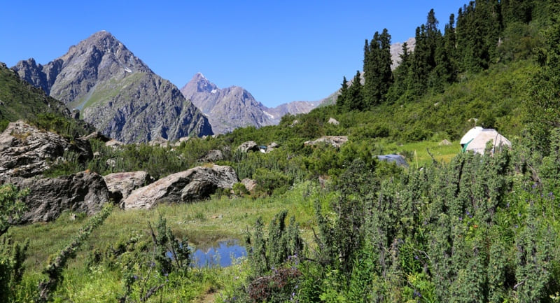
Gradually, the slope flattens out and from here begins a kurumnik with huge stones that must be overcome. Soon we reach the tract "Sirota" located at an altitude of 2940 meters above sea level. This place is an ancient moraine, which gradually slid down from the western slope of the Ala-Kel gorge.
The moraine leveled the gorge, the river laid its course and formed small lakes through which the river slows down its flow. In 2022, a small tent and yurt camp was located here, where it was possible to receive accommodation and food services.
A little further down the trail from the yurt camp is a wooden, primitive hut, which served as a shelter from bad weather for tourists, there is also a large fire pit around which logs are laid. According to legend, the hut was built in the 70s of the XX century by a mountain tourist from the city of Karakol named Sirota. Rest in the tract "Sirota".
Further hiking: valley "Sirota" - river and lake Ala-Kel (4 km).
After 600 meters from the tract, we move along a path with a slight rise, the path comes close to the river and then winds along the right bank. Soon we reach a clamp - a rock overhanging the river, the rock must be overcome along the very edge.
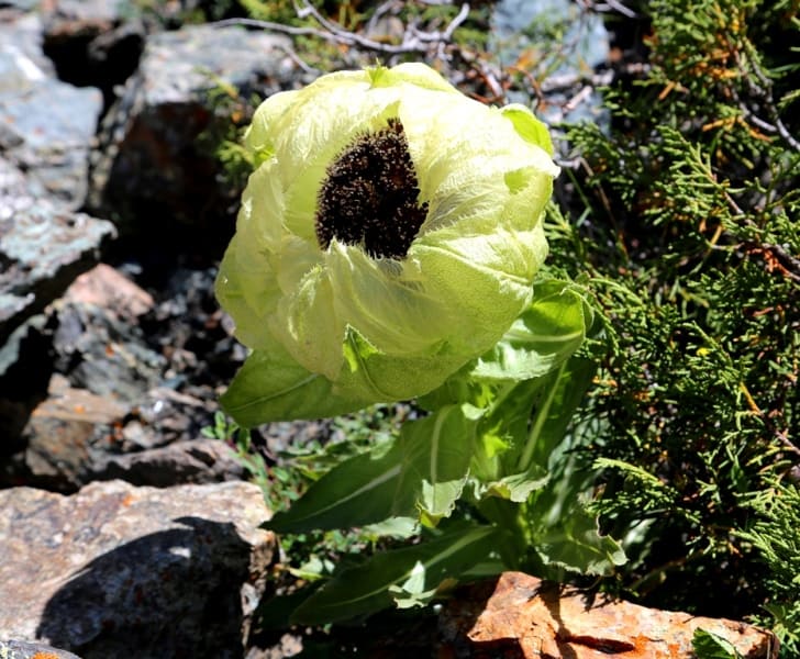
Further, a constant ascent begins along the talus, among the stones, the slope of the path reaches 40 - 45 degrees. In two places, not far from the trail, there is a unique alpine plant listed in the Red Book of Kyrgyzstan - Saussurea involucrata (Saussurea involucrata).
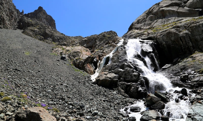
Before the very last, characteristically pronounced ascent, which leads to the jumper separating the gorge from the moraine lake Ala-Kel, there is another relatively flat area. Here travelers stop to rest. In the southern part of the moraine, the Ala-Kel River flows, which in the upper part consists of several waterfall cascades.
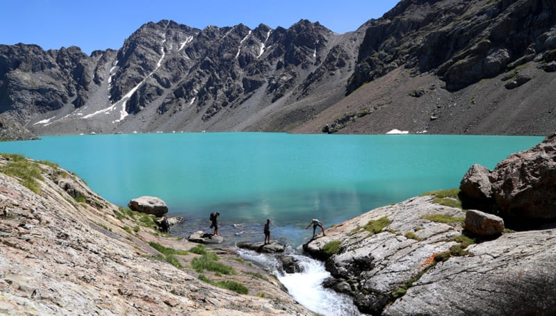
This is one of the picturesque places on the way to the lake. We make a short stop and continue climbing to the lake. Soon the trail leads us to a natural jumper, which offers a view of the eastern part of Ala-Kel Lake.
Alpine, flowing, fresh lake Ala-Kel is located at an altitude of 3532 meters above sea level, located in the upper reaches of the Ala-Kel River, in the Terimtor spur on the northern slope of the Terskey Ala-Too ridge, in the basin of the right tributary of the Karakol River.
The length of the lake from northwest to east is 2.8 kilometers, the largest width in the eastern part is 650 meters, the perimeter is 6277 meters, the area is 1.28 square kilometers, the catchment area is 9.46 square kilometers.
The lake of landslide origin was formed as a result of the springing of the river valley by a mountain landslide. The configuration repeats the trough valley, the depths of the lake increase from the upper reaches to the dam.
From the western part of the lake flows the turbulent and high-water river Ala-Kel, 4.5 kilometers long, which is the right tributary of the Karakol River. The mouth of the river is located at an altitude of 2475 meters above sea level.
In the watershed ridge, stretching from west to east, there is the Ak-Kel North pass with a height of 3858 meters above sea level. A trail leads from the pass to the Keldek gorge and further to the river and the Arasan gorge.
The lake receives its main food from a glacier located in the southeastern part of the lake. In the upper reaches of the glacier there is a peak of Alakul-Kyry with a height of 4322 meters above sea level. The flow from the lake is carried out through a natural bridge located in the western part.
Walk around the lake. Return to the camp near the Aitor river in the Karakol gorge (7 km). Arrival at the camp, dinner, overnight.
Day 3 Karakol Gorge - Karakol town (25 km).
Breakfast. Transfer to town of Karakol.


Note:
Author program of Alexander Petrov. Copying and introduction from the sanction of the author.
Photos by
Alexander Petrov