


![]()
You are here
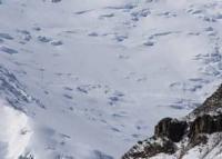
Yakkarcha Glacier.
Glaciers in Varzob gorge.
“Do I look into the blue where the eagle is circling,
Where a camel caravan sails into the horizon,
To the sea or the steppe, to the mountain peaks -
I see only your whole world eclipsed."
Baba Tahir. “Both heaven and earth...” End of X – XI centuries.
Trip from Dushanbe to Varzob gorge.
Yakkarcha glacier is located on eastern slope of Gissar ridge, in upper reaches of river of same name, in Varzob district, Gissar region. The glacier belongs to the Varzob-Kafirnigan river basin. The Yakkarcha River, 7.8 kilometers long, flows from the glacier.
At an altitude of 2479.2 meters above sea level, Yakkarcha merges with the Shaid River to form the Maykhura River. In turn, the Maykhura and Ziddy rivers merge to form the Varzob River. The sources of the river are located at an altitude of 3637 meters above sea level.
The mouth of the river is located at an altitude of 2479.2 meters above sea level. The glacier is located in the Maykhura basin - the right component of the Varzob River. From the north and west, the basin is limited by the Gissar ridge, and from the south by its spur, the Osman-tala ridge.
Yakkarcha is a cirque, valley glacier with a length of 1.15 kilometers, an area of 0.54 square kilometers. Its average width is 470 meters, the end of the glacier is at an altitude of 3880 meters above sea level. Such small glaciers react very actively not only to climate change, but also to the weather of one winter.
One snowy winter can not only slow down the retreat of a glacier, but even cause it to advance by several meters.
Historical information about Yakkarcha glacier.
From 1972 to 1977, the Jakarcha Glacier retreated 25 meters at an average retreat rate of 5 meters per year. During the period from 1983 to 1986, it retreated on the left side at a rate of 2 - 4 meters per year, in the middle part 1 - 2 meters per year.
Currently (2003) it is retreating by 2 - 3 meters per year, while its surface is sinking by an average of 3 meters per year. Thus, the glacier loses mass, both due to a reduction in length and due to a decrease in thickness. The thickness of the Yakkarcha glacier is no more than 50 meters, so melting from the surface is more dangerous for it than the retreat of the tongue.
Geographic coordinates of Yakkarcha glacier: N38°59'00 E68°33'44
Authority:
"Glaciers of Tajikistan". Ministry of Nature Protection of the Republic of Tajikistan. Main Directorate for Hydrometeorology and Natural Environment Observations. Dushanbe. 2003.
Photos by:
Alexander Petrov.