You are here
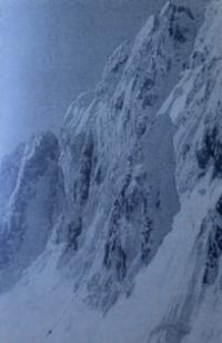
Peak Svobodnaya Korea.

Mountain peaks in Chui region.
“Well, what lies ahead for us?
Won hang over the bowl of the valley
The rains that didn't fall
Latent avalanches."
Yuri Vizbor. 1963.
Climbing peak Svobodnaya Korea.
Svobodnaya Korea Peak, 4740 meters above sea level, is located in the mountains of the Kyrgyz Ala-Too on the territory of the Ala-Archa Natural Park, in the Alamudun district in the Chui region. The summit is located in the sublatitudinal spur of the Aksai horseshoe.
From the northern slopes of the summit, the Aksai glacier begins, 6.4 kilometers long. On the southern side of the peak there is a 5 km long Topkaragay glacier. The height of the peak, according to various sources, ranges from 4740 to 4778 meters above sea level (the description indicates the height taken from a topographic map at a scale of 1: 200,000).
One of the classic routes to the peak of Free Korea is its northern face with a height difference of 650 to 900 meters. There are about 14 routes of difficulty categories from 5A to 6A along the wall. Until the end of the 80s of the last century, the northern wall of the summit was considered one of the most prestigious and difficult.
The height of the glacier under the northern wall is about 4000 meters above sea level. The wall vertically consists of three parts: an ice lower part, a steep rocky middle part and a snow-covered, icy upper part. The average steepness of the northern wall is about 65 degrees.
The weather is unstable, most often in the afternoon it starts to rain or snow, the wall is not illuminated by the sun. The northern wall of Free Korea is almost always icy and covered with snow, there are many dangerous stones, the relief of the wall is badly destroyed.
Climbing routes requires tactics that take into account dangerous factors when climbing. The descent from the top is difficult.
Options for descending from the top of Free Korea:
a) south along route 4B to the Top-Karagay gorge,
b) north along Lowe's route.
First ascent to Svobodnaya Korea Peak:
1959
The first ascent along the northwestern wall, along the eastern ridge, was made by a group led by Andreev, difficulty category 5A.
1961
Climbing along the route 5A of difficulty category, on the right side of the northern wall, led by Lev Myshlyaev.
1966
Climbing route 6A of difficulty category on the left side of the wall with access to the eastern ridge under the guidance of B.A. Studenina, Alma-Ata city.
1969
Climbing along the center of the northern wall of the Svobodnaya Korea peak, exit to the left of the summit by climbers from Krasnoyarsk, under the guidance of Valery Bezzubkin, 6A category of difficulty.
articipants: Yuri Andreev, Vladislav Lyakh, Viktor Sukhanov, Vladimir Ushakov. Climbing climbers from Ukraine led by A. Kustovsky on the left side of the route, 6A category of difficulty.
1974
Climbing led by Boris Bagaev. Participants: Valery Bezzubkin, Vladimir Kokorev, Vladimir Milko, Vitaly Paramonov. Difficulty category 5B on the "triangle" of the northern wall
1975
Climbing along the central part of the wall, bypassing a huge overhanging cornice, climbers led by Y. Popenko from Alma-Ata.
1975, July.
Climbing along the couloir of the northern wall to the peak of Consolidated Korea, climbed by Henry Barber alone.
1988
Passing the most difficult route along the northern wall of the summit under the guidance of S. Semiletkin. difficulty category 6B.
Geographical coordinates of peak Svobodnaya Korea: N42°29'49.55" E74°32'36.76"
Low Route up Svobodnaya Korea ("Free Korea", 4,740 m, 5A).
Opened in 1976 by the American D. Low, who climbed it alone, this route goes up to Svobodnaya Korea peak along the wide snow gully that opens to the right of the middle bastion, on the northern face of the mountain.
This snow and ice route is about 800 meters long, with 40 - 50° steepness, and takes ten hours of very tough climbing with ice axes and hammers, rope and ice screws (5A). You must start off very early, about 3 a.m., in order to get over the first part of the gully before daylight, since there are slides during the day.
Once out of the gully, it takes about a two hours' climb along the western ridge to get to the top, but this part of the route is not very interesting and most climbers descend from the top of the gully. There are two possible return routes.
The first passes by the southern side along the wide snow slopes in the direction of the western summit and the Top-Karagay valley. This is a very easy route, but it takes about twelve hours because it crosses a wild, deserted area without any tracks or paths.
So you cannot climb up the Low route gully and return to the Ala-Archa base camp the same day; you have to bivouac, which means bringing along all the necessary gear. The alternative route consists in crossing up to the northwestern ridge (I hour) and descending on the northern snow and ice face between Mt. Svobodnaya Korea and Aktoo Peak (4,620 m).
Rappelling down the steep snow slopes is rather demanding, but you will reach the Ak-Say glacier in three or four hours. Another possibility is to make a crossing along the snow and ice domes of Aktoo Peak (and Teketor Peak) and then descend by means of the pass between Box and Teketor peaks.
This route is long but rather easy; it takes five or six hours to return to the Korona refuge or Ratsek bivouac.
Authority:
Alexander Petrov.
http://mountains.tos.ru/clmb.htm
http://www.mountain.ru/article/article_display1.php?article_id=8549


