You are here
Ormandy-Bulak burial ground.

Archaeological monuments of Kazakhstan.
"History is a witness of the past, the light of truth, a living memory, a teacher of life, a messenger of antiquity"
Mark Tullius Cicero.
Archaeological sights of Kazakhstan.
The Ormandy-Bulak burial ground is located at an altitude of 349 meters above sea level, located in the north-west of the Zerenda mountains and north-east of the Zhylandy mouAntains, 860 meters north of the R 230 highway between the villages of Lobanovo and Zerenda, 4.0 kilometers to the southeast from the village of Karsak of the Trinity rural district, 6.6 kilometers to the west and a little north of the village of Baiterek, 18.2 kilometers to the north-east of the village of Kumdykol in the Zerenda district in the north-west of the Akmola region.
The object is localized on one of the elevations of the hilly area, 800 meters north of the Kubasha River, the right tributary of the Chaglinka River, between an artificial forest plantation stretching from the burial ground to the north in the direction of the village of Karsak, and a pine forest located southwest of the burial ground.
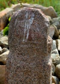
An improved Zerenda dirt road runs 700 meters from the burial ground to the south and southwest - Karsak. The object of study is a series of ancient tomb structures, consisting of almost seventy stone enclosures of the Bronze Age, several medieval (Old Turkic) and ethnographic grave structures.
The accumulation of Bronze Age objects at the burial ground can be divided into three groups. The first has about twenty-seven stone enclosures, stretched along the north-northwest and south-southeast lines. The second group is not numerous and consists of nine stone enclosures of small size, closely spaced in relation to each other.
This group is oriented mainly along the north-south line. The third group, with the largest number of enclosures, namely twenty-nine, is localized randomly on the terrain, but the group is noticeably stretched along the north-south line.
The distance between separate objects in the third group is large, due to than this group has the largest localization area on the ground. To the south-southwest of the main accumulation of stone enclosures, a single small stone enclosure is fixed, judging by the features of the tomb structure, it is also preliminarily dated to the Bronze Age.
It should be noted that the undertaken division of the stone enclosures of the Bronze Age into groups is largely conditional. Nevertheless, the described location of the objects on the site may be evidence of the chronological, cultural, or ritual and funerary features of the ancient burials at the site, which, of course, requires in-depth study.
o the south-east of the accumulation of tombstones of the Bronze Age, several small stone excavations are localized, typical for necropolises of ethnographic time, among which fences of the ancient Turkic period are fixed.
Apparently, for the construction of the necropolis of ethnographic time, the stones of the tomb structures of the ancient Turkic time were used as a material, and therefore it is difficult to identify a specific number of certain late structures on the site.
The first studies of the burial ground were carried out in 2010 by the archaeological team of the State Institution "Center for the Protection and Use of Monuments of Historical and Cultural Heritage of the Akmola Region" under the leadership of A.Zh. Tyulebaev.
Geographical coordinates of Ormandy-Bulak burial ground: N52°55'15.73" E68°51'09.68"
Note:
If you are using geographic coordinates for Google Earth or Google Maps navigation systems, you must remove the last two digits from geographic coordinates and " (hundredths of a second) and enter the result in the input line.
Example: N51°44'09.67" E72°39'40.81" = N51°44'09 E72°39'40


Authority and photos:
Baitleu D.A., Samashev Z., Seibert V.F., Magzumov A.M., Tyulebaev A.Zh.
"Research of the Ormandybulak burial ground in the Zerenda district of the Akmola region."


