







You are here
Upper Kara-Tokoy West Lake.
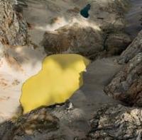
Moraine lakes of Kara-Tokoy tract in Chatkal Range.
"Here, above, winter weaves its first carpet.
Here, above, spring's fervor is born.
The valleys are still plunged in darkness,
And the silver moon glides along the mountain ridges."
Alykul Osmonov. "Kyrgyz Mountains." 1946.
High-mountain lakes on western slope of Chatkal Range.
The high-mountain, freshwater lake Upper Kara-Tokoy West is located at an altitude of 3,329 m. a. s. l., in the upper reaches of the river of the same name, on the western slope of the Chatkal Range in the Chatkal District of the Jalal-Abad Region.
The Upper Lake Kara-Tokoy West extends from southeast to northwest. It is 377 meters long, with a maximum width of 182 meters in the southern part. Its water surface area is approximately 0.04 sq. km., and its shoreline is approximately 0.96 kilometers long.
Thus, the three lakes form a unique altitudinal sequence: from the Lower Lake, located at an elevation of 3,206 meters, to the Upper Lake, at an altitude of 3,329 meters. The difference in elevation between the outermost lakes is 123 meters. The ratio of their areas is also interesting.
The Middle Lake, despite its intermediate location, has the largest water surface area – approximately 0.06 square kilometers. The Lower Lake is significantly smaller – approximately 0.01 square kilometers, while the Upper Lake is approximately 0.04 sq. km.
This once again demonstrates that the size of high-mountain moraine lakes depends not only on their location within a single river system but also on the individual structure of the glacial basins and the moraine ridges that dam them. The lakes are successively connected by the Kara-Tokoy West River, which originates from the Kara-Tokoy Glacier located on the western slope of the Chatkal Range.
Together, the three lakes form a compact system of high-mountain lakes located between the modern Kara-Tokoy West Glacier and the Kara-Tokoy River valley. Their successive arrangement allows us to trace how glacial and moraine processes shaped the complex system of water accumulation and movement in the upper reaches of the Kara-Tokoy.
Geographical coordinates of Upper Kara-Tokoy West Lake: N41°59'08 E71°47'31
Authority:
Alexander Petrov.
Photos by:
Alexey Ognev. Bishkek.