







You are here
Perevalny Glacier in headwaters of Ozernaya River.
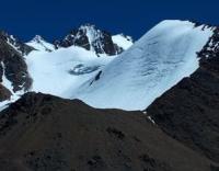
Glaciers in headwaters of Ozernaya River.
"The first information regarding the glaciers of the Zailiysky Alatau appeared in the literature relatively late. It dates back to 1899 and concerns the Chiliko-Keminsky mountain cluster, one of the areas most remote from human settlements. A more thorough study of the Zailiysky Alatau glaciers began in 1902 at the initiative of S. E. Dmitriev."
"Glacial Structures of the Northern Tien Shan – Zailiysky Alatau". https://elib.rgo.ru
Glaciers on northern slope of Big Almaty Gorge.
Perevalny Glacier is situated at high altitude in the headwaters of the Ozernaya River within the Big Almaty Gorge. It lies west of Cherny Glacier and southeast of the Ozerny Pass (elevation 3,503.3 m a.s.l.) on the northern slope of the Zailiysky Alatau Range, in the Karasay District of the Almaty Region.
Perevalny Glacier is located in a cirque; its upper section spans 340 meters in width, while the lower section is approximately 500 meters wide. The glacier extends for 1.1 km along the main ridge of the Zailiysky Alatau, running from northwest to east.
The length of the glacial flow reaches 1,000 m; the total surface area of the glacier is 0.28 km. sq., and its perimeter is 2.89 km. The area of the exposed glacier tongues is 0.65 km. sq., while the firn fields cover 0.82 sq. km; buried portion of the tongues: 0.72 sq. km; total area: 219 sq. km.
Positive glaciation difference: 185 m; negative: 305 m. Glaciation coefficient: 1.3. Morphologically, the glacier is of the cirque and hanging type; it belongs to the Ozernaya River basin. There is no distinct glacier tongue. The glacier consists of two chambers with surrounding walls averaging over 4,000 m in elevation.
From this cirque, it extends into the main valley, where its exposed section - buried beneath moraine - reaches the saddle of the main ridge. The lower surface of the glacier is covered with rock debris. The moraine-covered section of the glacier has dammed and filled the channel of the Ozernaya River.
The moraine deposits consist primarily of schist. Near the exposed part of the glacier, the moraine deposits form a chaotic, hummocky terrain. The moraine deposits covering the lower half of the glacier appear older than those on the upper, buried half.
The glacier's upper accumulation zone lies at an elevation of 4,048 m a.s.l. The terminus of the exposed section is located at an elevation of 3,642 m a.s.l. The glacier is nourished by the accumulation of snow, firn, and solid precipitation. Transverse crevasses are present in the upper, eastern section.
In the central section, the glacier flows around a weathered rock outcrop. In its upper reaches, the glacier splits into two branches - western and eastern - of roughly equal size. The left branch has a north-westerly aspect. The exposed terminus of its tongue lies at an elevation of 3,500 m a.s.l., its terminus, buried under moraine deposits, lies at an elevation of 3,460 m.
The right branch shares the same aspect; its exposed section terminates at 3,550 m, while the ice-covered section ends at an elevation of 3,410 m. In the northwestern section of the glacier's moraine, 48 meters from its lower edge, lies a small moraine lake measuring 70 m in length and 27 m in width.
The glacier of the same name is located in the upper reaches of the Ysyk-Ata Gorge, in the district of the same name within the Chuy Region of Kyrgyzstan.
Geographic coordinates of Perevalny Glacier: N42°57'17 E77°01'33
Authority:
Alexander Petrov.
Article: "Glacial Structures of the Northern Tien Shan – Zailiysky Alatau"
https://elib.rgo.ru/safeview/123456789/226999/1/0LPQtdC+0LsuMjRfVGFsZ2FyLCBnbGF2bmF5YSB2ZXJzaGluYSBaYWlsaWlza29nbyBBbGF0YXUsIGJsaXoucGRm
Photographs by:
Alexander Petrov.