You are here
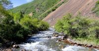
River Chemalgan. Almaty region.


Walking Tours Almaty.
“Nature encourages no looseness, pardons no errors”
Ralph Waldo Emerson.
Hiking routes in Almaty vicinities.
The river Chemalgan begins with northern slopes of the ridge Zailiysky Ala-Tau. Morphological conditions of a freezing are similar to conditions in Uzun-Kargaly river basin here. The main top of the gorge Chemalgan has a mark of 4094 meters above sea level, the snow zone extends down no more than to 150 meters above sea level.
In sources of the river there are four glaciers which were for the first time registered in September, 1933 by V. G. Gorbunov. Three glaciers are corrie glaciers, one - hanging glaciers. All of them are directed by the ends to the North in a wide hollow of an ancient freezing.
The largest glacier - extreme western - has length about 1,5 kilometers. It comes to an end under a long frontal moraine and here the beginning to the main source of the river Chemalgan. Other two corrie glaciers are located to the east, separating from western and from each other short rocky spurs.
The fourth glacier represents the snow occupying the top part of a back wall of corrie at the bottom of which there is a small lake. Before the end of a glacier shaft of moraines last.
Authority:
Catalog of glaciers of the USSR. - Leningrad, 1967, t. 13, century 2. p. 2. Tuyuksu glaciers (Northern Tien Shan). L.: Gidrometeoizdat, 1984. Freezing of Tien Shan. Under the editorship of N. B. Dyurgerov. - M, 1995. Freezing of Zailiysky Ala Tau. - M.: Science, 1969. Palgov N. N. Bolshealmatinsky freezing knot in the ridge of Zailiysky Ala Tau.
Photos
Alexander Petrov.


