You are here
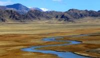
River Kegen.

Discovery Kazakhstan.
“Travel is fatal to prejudice, bigotry, and narrow-mindedness, and many of our people need it sorely on these accounts. Broad, wholesome, charitable views of men and things cannot be acquired by vegetating in one little corner of the earth all one's lifetime”
Mark Twain.
Nomad Routes from Astana to Almaty.
The Kegen River is located in the Kegen region in the east of the Alamata region. In the place where the Kegen river gets the name Sharyn, the height above sea level is 1411.6 meters, in the place where it is formed from the confluence of the rivers: Shalkudysu, Karasu, Eshki-Karasu and Tyshkynbai-Karasu, the height above sea level is 1908.3 meters above sea level.
The vertical drop on the river is 496.7 meters. The Kegen River gets its name 4.5 kilometers to the west and slightly north of the village of Karasaz, which is 11 kilometers from Lake Tuzkol, to the west of the Shalkudysu river valley.
The river begins its journey in a wide valley between the southern slopes of the Ketmen ridge and the northern slopes of the Elshyn-Buyryk mountains, flows to the southwest, bypassing the northern slopes of the Sholadyr mountains.
Then it turns to the north-west and, bypassing the southern slopes of the Temirlik mountains, approaches the village of Kegen along a wide valley Before the southern slopes of the Kuluk-Tau mountains, in the vicinity of the village of Zhalauly, the river flows westward along a wide valley opposite the southern slopes of the Bestobe mountains.
In the vicinity of the Koltykbastau ravine, Kegen enters the canyon and gradually the river reaches the Bestyubinskoye reservoir with a length of 4.5 kilometers. Passing the reservoir, the Kegen river passes a 9-kilometer underground diversion canal and in the southern part of the Kalasai valley at the mouth of the Shet-Merke river at an altitude of 1411.6 meters above sea level it loses its name.
The length of the Kegen River is 122 kilometers. From the headwaters to the mouth of the Karkara River, Kegen has long and beautiful meanders that stretch over a long distance in the flat part. After its source, the river in the vicinity of the Komirshi village receives an extended, right tributary Tentek-Karasu, into which, in turn, the Komirshi and Insazkarasu rivers flow in front of the mouth.
From here to the village of Kegen the river flows without right-hand tributaries. At an altitude of 1732 meters above sea level, the river, after the village of Kegen, receives a small tributary Shybysh with a length of 11 kilometers.
Thus, along its entire length, the river has only two right tributaries, this is due to the aridity of the southern part of the bordering mountains. On the left side, after the source, the Kegen river receives the first long tributary Ulken-Karasu, then at an altitude of 1868.9 the river receives the Karasu tributary, then the Karabulak and Saryzhaz tributaries follow.
The next tributary appears only in the vicinity of the village of Zhalauly at an altitude of 1789.7 meters above sea level - Moshik. Soon the river receives tributaries: Karasu, Orta-Karasu and the deepest and longest tributary - Karakara, which originates on the northern slopes of the Terskey Ala-Too ridge in Kyrgyzstan.
The mouth of the Karkara is located at an altitude of 1,777.8 meters above sea level. In the vicinity of the Taldy village, the river receives its right tributaries: Ulken-Taldybulak, then the rivers Beskaragay, Kensu, Orta-Merke follow.
The Moinak HPP was also built on the river in 2011.
Geographic coordinates of the Kegen River: N43 ° 00'27.47 "E79 ° 15'16.19"
Authority and photos by
Alexander Petrov.


