


![]()
You are here
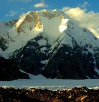
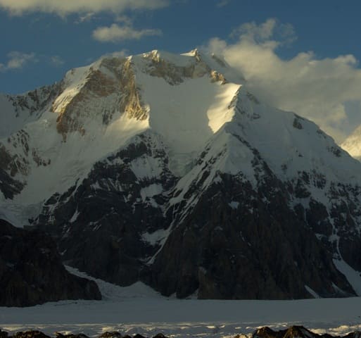
Chapaev Peak.
Guided walking tour Karakol and Cholpon-Ata.
"The mountains are wise and misty
Will rise above the clouds
And they will lick our wounds
Tongues of glaciers."
Yuri Vizbor. 1962
Special excursion in settlement Kochkorka.
Chapaev Peak, 6371 meters above sea level, is located in eastern part of Tengri-Too ridge, in mountains of Central Tien Shan, 3.4 kilometers southwest of Khan Tengri Peak, in Ak-Suu district of Issyk-Kul region. The peak is located on the main ridge of the ridge, 4.5 kilometers northeast of the peak of Maxim Gorky, 6050 meters above sea level.
The state border between the Republic of Kazakhstan and the Kyrgyz Republic runs along the crest of the ridge. Climbing to the top along the classic route (along the Kolkolnikov path) begins from a saddle 5800 meters above sea level. The saddle is located between Khan Tengri Peak and Chapaev Peak.
The northeastern ridge, going to the top, then takes an almost latitudinal direction - to the east. To reach this part of the ridge you need to go through a steep, avalanche-prone slope. You have to climb either along one of the slopes or along the ridge itself. The last section of the path before the summit is very steep, almost an ice wall.
History of ascents to Chapaev Peak.
August 20, 1937 For the first time, Kazakh climbers Tyutyunnikov, Bekmetov and Protserov climbed to the top under the leadership of E.M. Abalakova.
Geographic coordinates of Chapaev peak: N42°11'55 E80°08'09
Authority:
Alexander Petrov.
Zatulovsky D.M. “On the glaciers and peaks of Central Asia.” OGIZ, State Publishing House of Geographical Literature. 1948
Photos by:
Vladimir Serbenko.
"The mountains are wise and misty
Will rise above the clouds
And they will lick our wounds
Tongues of glaciers."
Yuri Vizbor. 1962