You are here
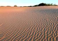
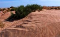
Sands Karynzharyk on Mangystau.


Mountain hiking on sights Mangyshlak.
“may came home with a smooth round stone as small as a world and as large as alone”
E.E. Cummings.
Popular destinations on Mangyshlak.
The Karynzhyryk sands are located in the Karakiyansky district of the Mangystau region, these are the longest sands on Mangystau. The sands are located in the eastern part of the Kenderli-Kaysan plateau and on the western side of the Karynzharyk depression, located in the Ustyurt natural reserve.
Sands begin from the southern part of the state border of Kazakhstan and Uzbekistan. At first, the sands stretch to the northeast along the eastern benches of Kayasanirek, after the benches end, the sands take the north direction and stretch to the southern tip of the Karashek litter.
North of the village of Ak-Kuduk sands cuts through the ridge Zhasasynagy from the south-east to north-west. In the northern part of the sands is the dominant mountain Karashek height of 1194 meters above sea level, to the northeast of Karashek there is the mountain Kishi-Karashek with a height of 62 meters above sea level.
Starting from the natural boundary of Unere, which is located on the territory of the Ustyurt nature reserve and up to the Karashek mountain, the Karynzharyk sands border the western slopes of the Karynzharyk depression. In the southeastern part of the Karynzharyk sands there is the Chagallyshor depression, the northern part of which cuts off the border of Kazakhstan and Uzbekistan.
The length of the sands from the south-west to the north is 136 kilometers, the width south of the village of Ak-Kuduk is 15 kilometers. From the village of Senek, through the village of Ak-Kuduk and further along the western edge of the Karynzharyk sands, there is a road to the frontier post and the cordon cordon Unare.
Karynzharyk sands are represented by hilly ridge sands, the height of sand ridges is 10 - 15 meters, the depth of sand cells is also from 10 to 15 meters.
Geographic coordinates of central part of Karynzharyk sands: N42 ° 53'57 E54 ° 10'54
Authority and photos
Alexander Petrov.


