You are here
Lake Kushmurun.

Lakes of Kostanay region.
“To travel is to live”
Hans Christian Andersen.
Botanical Holidays in Kostanay region.
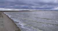
Lake Kushmurun (Kusmuryn) is located on the border of Auliekol and Karasu regions in the eastern part of the Kostanay region in the Turgai hollow, 37.8 kilometers northeast of the village of Aulikol and 92.9 kilometers southeast of the city of Kostanay, at an altitude of 103 meters above sea level.
The lake is located at 103 meters above sea level. The Ubagan River flows into Lake Kushmurun, in the south, and the swampy channel of the Kaib River flows out of the lake in the north. The area of the lake is 400 - 415 square kilometers, the catchment area is 10.5 thousand square kilometers.
The basin of the lake stretches from south-west to north-east for 40 kilometers, width, in the central part of the lake is 11 kilometers, the maximum depth of the lake is 3.5 meters. The northern and southern parts of the lake are swampy in river beds.
The flat bottom is composed of clay and loamy soils covered with layers of silt. The banks in the middle part are up to 5 - 7 meters high. To the southwest of Kushmurun there is the Amankaragai forest. The water is greenish-yellow in color, salinity 1 - 25 grams per 1 liter.
The catchment area is mostly plowed up. The lake is home to waterfowl and wading birds. Perch, bream, carp are found among fish. These lakes are the recipients of small steppe rivers flowing from the sides of the hollow and the ephemeral spring runoff formed by the melting of snow in the bottom of the hollow itself.
On the shores of Lake Kushmurun there is one of three places where black alder and other relict plant species grow in Kazakhstan.
Geographic coordinates of Lake Kushmurun: N52 ° 39'59.75 "E64 ° 46'09.89"
Authority:
https://ru.wikipedia.org/wiki
Photos by
Alexander Petrov.


