


![]()
Вы здесь
History of exploration western part of Kakshal-Too ridge.

.")
.")

.")
.")

Off-road tours on roads Tien-Shan mountains.
"None of the local residents know who owns the Chon-Terek tract: every summer, the Chinese Kyrgyz roam in this tract due to the accessibility of the Terek pass, and in the winter, sometimes Russian Kyrgyz also come along the ice of the Chon-Uzengyu-Kuush river, which, flowing among the gorges , completely inaccessible in summer"
Military topographer, Lieutenant Ledomsky.
"Unfortunately, from this very elevated point, due to the pile-up of mountains and the winding course of the gorges, there is no picturesque view at all, which one might expect. A sea of white peaks - and nothing more. The highest points of the Kok-Shal peaks, according to the approximate calculations of K. A. Larionov, reach 16,000 - 17,000 feet."
"Kashgaria and passes of Tien-Shan." Travel notes of N. Zeland. Omsk, 1887.
"Although the Kok-Shaal ridge is cut across its entire width by river valleys extending southeast into Kashgaria, it still maintains elevations exceeding 4,500 meters throughout, and many of its peaks, located in the Kok-Kiya massif, reach over 5,000 meters."
"Volosts and Settlements of Semirechye Region." Issue 7. 1893.
Trip to Kakshaal-Too mountains.
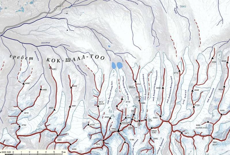
Name of the Kakshaal-Too ridge comes from the Kyrgyz "kak shaal" - "belt stirrups" (the term putlische means the belt on which the stirrup is hung from the saddle). The history of exploration of the western part of the Kakshaal-Too ridge occurred either indirectly or purposefully.
Some expeditions of researchers and travelers went along the caravan route, which began from the southern coast of Lake Issyk-Kul, passed through the Djuku gorge, the Arabel plateau, the Taragai River and then went along the right bank of the Naryn River to the left tributaries of the Karakol or Ulan River.
At the wide spills of the Naryn, they crossed to the left bank of the river and went through the Kyubergenty Pass to the Kagalyachap Plateau and then followed the valleys of the Eastern and Western Aksai to the Terek Western Pass or the Torugart Pass with an exit to Kashgar.
Some expeditions visited Lake Chatyr-Kol and went across the Atbashi River to the Naryn fortification or further to the southwest through the Fergana Range.
History of exploration of western part of Kakshaal-Too Range.
1858. The area of the western part of the Kakshaal-Too ridge was first visited by the Kazakh traveler Chokan Valikhanov in 1858 on his way to Kashgar. In his diary entries "Kashgar Diary. The Top of the Zaukinsky Pass" there are notes about passing the Kyubergenty Pass, from which the exit to the Kagalyachayach plateau opens.
Chokan describes this unremarkable, at first glance, place in sufficient detail. After spending the night in the vicinity of the Kagalyachap plateau, Valikhanov's caravan proceeded along the valley of the Eastern Aksai and then from the valley of the Western Aksai crossed the Terek Western Pass and descended along the southern slope of the Kakshaal-Too ridge to Kashgar.
1866. The area of the western part of Kakshaal-Too was visited in 1867 by Nikolai Alekseevich Severtsov (1827 - 1885), a Russian zoologist and traveler. The expedition he organized passed from the southern shore of Issyk-Kul, the Barskaun gorge, the Dzhuuk pass and reached the upper reaches of the Naryn, the Akshiyrak ridge and descended along the right bank of the Naryn River.
In the area of the Ulan River (the left tributary of the Naryn River), the expedition crossed the wide floodplains of the Naryn to the left bank of the river, ascended to the upper reaches of the Ulan River, then turned west along one of the tributaries, reached the Ulan Pass at an altitude of 3791.4 meters above sea level and descended along the Ulan West River to its confluence with the Dzhaldzhir River.
Then, through the Kyndy Pass at an altitude of 3398.1 meters above sea level, they entered the valley of Western Aksai. The expedition visited the Terek Gorge, the northern spurs of the Kok-Kiya Range, the river of the same name, reached Lake Chatyr-Kol, visited the Naryn fortification and returned to the Tokmak fortification through the Dolon Pass and the Boom Gorge.
1867. On October 16, 1867, Captain Reintal made a trip from the Naryn fortification with a visit to Lake Chatyr-Kol and descended to the city of Kashgar through the Torugart Pass.
1867. Baron F. R. Osten-Sacken, Captain Reintal and Colonel V. A. Poltoratsky. They made a research expedition and visited: Kastek Gorge - Chu River - Shamsi Pass – Pass Kyzart - Son-Kul Lake - Naryn River - Djaman Davan Pass - Arpa River Valley - Western Aksai Valley - Chatyr-Kul Lake - Toyun and passed through Son-Kul to Kochkorka, Tokmak and Pishpek. Large botanical collections were received by the Botanical Garden and processed by O. Saken together with Ruprecht.
Together with O. Saken, Colonel V. A. Poltoratsky participated in the expedition, who conducted a survey and filming of many previously completely unknown places in the area of the indicated route, and before that, in the spring of the same year, independently surveyed the Tekes area and reached the foot of the Muzart Pass.
One of the participants in the survey party, which was under the general command of Poltoratsky, Captain Reintal, reached Kashgar and in the two works he left behind, he reports a number of new interesting information concerning the route he had taken. 1868. In 1868, an expedition of Major General Ya. L. Kraevsky took place.
The route of the researchers passed through Tokmak - Boom Gorge - Dolon Pass - Naryn Fortress - Karakoyun - Arpa Valley - a survey was made at the Torugart Pass. A description of the entire route and the places passed was prepared.
1868, summer. In the same year, an expedition was made by doctor, member of the First Russian Geographical Society A. V. Bunyakovsky, who visited Lake Son-Kol - Lake Chatyr Kul - the Arpa River Valley and from here through the Toguz-Tora ridge and the Kugart Pass went to Fergana, and used barometric methods to determine the altitude of a number of points along this route.
V. V. Radlov, at that time a teacher at the Barnaul Mining School, and later a famous academician, worked in various places in the region, studying the languages of the Sibintsy, Solons and Kara-Kirghiz, collecting materials on the Dungan uprising and conducting archaeological excavations. The main areas of his work were the Borokhudzir River valley, the Chu River valley and Lake Issyk-Kul.
1869. The work of the demarcation commission between the Russian Empire and China continued under the command of Major General I. F. Babkov, and the commission reached the Khabar-Asu Pass in Tarbagatai. Then, member of the I. Russian Geographical Society Baron A. V. Kaulbars with the military explored the western part of the Kakshaal-Too ridge.
The western part of the Kakshala-Too ridge was first described by the Russian geographer and military explorer Alexander Vasilyevich Kaulbars, who in 1869 led an expedition that studied the area south of the Naryn River. (A.V. Kaulbars. "Materials on the Geography of the Tien-Shan").
On May 31, 1869, a military scientific expedition headed by Staff Captain A.V. Kaulbars set off from Verny. It included topographers O. Reinhardt and Fyodor Petrov, builders Nesterov and Semyakin, as well as an interpreter, a guide, and an escort group of Semirechye Cossacks.
The participants faced the difficult task of mapping the mountains formed by the Fergana, Terskey-Ala-Too, Kakshaa-Tau, and Alatau ridges. They were to advance to the eastern borders, closely approaching the Meridional Range with its inaccessible peak Khan-Tengri, determine the heights of key points of the route, conduct a cartographic survey of the routes leading to Kashgar and Kuldja, and describe in detail the explored territories.
This was one of the many expeditions that were sent in those years to the Tien Shan in connection with the growing interest of Russia in Central Asia. During the tour of the border regions, Baron Alexander Vasilyevich Kaulbars (1844 - 1929), the future cavalry general and the first commander of the aviation of the Russian army (1915), and then the senior adjutant of the headquarters of the troops of the Semirechye region, placed at the head of the Russian embassy in Kuldja (a protectorate of Russia from 1871 to 1881), visited the western part of Kakshaal-Too.
The detachment of A.V. Kaulbarsa climbed the Kubergenty Pass, crossed the Kagaliachap Plateau and went west along the Myudyuryum River (one of the tributaries of the Eastern Ak-Sai, originating from the glaciers of the Kyzyl-Asker mountain-ice massif) and mapped the previously unknown Kakshaal-Too and Borkoldoy ridges (at that time Borkoldoy was taken for a lateral spur of Kakshaal-Too, and in some ways this idea turned out to be correct, since here the watershed runs precisely along Borkoldoy, and not along Kakshaal-Too).
They made a huge journey from the eastern end of Issyk-Kul to the upper reaches of Naryn, to the Ak-Shyirak mountain group, to the Kakshaal and Atbash ridges, past Chatyr-Kul, the Naryn valley, the Susamyr mountains and the Utmek pass, and left Jetysu for Talas. The expedition was accompanied by a survey of the route. and determining the heights of many points, as well as generally a detailed geographical description of the places passed.
1872. Setting out at the head of the embassy to Kashgar, Baron A. V. Kaulbars carried out additional surveys in the area bordering Kashgar in the western part of the Kakshaal-Too ridge, and Lieutenant Colonel K. A. Scharngorst, who was part of the mission, determined 9 new astronomical points in the area of the syrts of the Naryn system and the ridges bordering China and checked 3 points of Golubev and Struve.
1873. The famous English geologist Stolichka worked in the area bordering Kashgar, Lake Chatyr-Kol, the valley of the Western Aksai River, together with the geographer Trotter and Colonel Gordon (T. E. Gordon).
1878. N. V. Mushketov visited Tien-Shan for the second time, this time his research covered only a small corner, namely, Mushketov, having crossed from Fergana via the Suyok Pass, passed through the Chirmash Valley, visited Lake Chatyr-Kul, the valleys of the Arpa and Alabuga Rivers, and through the Chartash Pass he again reached Fergana.
1882. This year, the Russian-Chinese demarcation commission began its work under the command of Generals Friede (border with Kuldzha) and Medinsky (border with Kashgar). The work of the commission is of interest in that it surveyed many previously completely unexplored, very difficult to access and interesting areas of Tien-Shan.
In addition, a member of the commission, Bilkins, collected a geological collection, which he handed over to I. V. Mushketov.
1885. The southern shore of Lake Chatyr-Kol was surveyed by Captain Galkin. In the last days of October, the expedition of N. M. Przhevalsky, who was returning from his 4th journey, left Kashgaria for Dzhetysu through the Bedel Pass. From the Bedel Pass, Przhevalsky went to the Kara-Sai River, then to the Arabel Plateau through the Kashka-Su and Zauku Passes, Pokrovskoye to Karakol.
In addition to N. M. Przhevalsky, this expedition included, as is known, Lieutenant V. I. Roborovsky, volunteer P. K. Kozlov and geologist K. I. Bogdanovich. The mentioned expeditions were not devoted to the study of Tien Shan, their main goal was the Kunlun and Tibet ranges, in addition, the routes of these expeditions crossed the Western Kokshaal-Too through the Bedel Pass, located slightly to the east of the breakthrough of the Uzengegush River, that is, far to the east of Kyzyl-Asker, so the researchers could not see this mountainous region even from afar.
1886. G. E. Grum-Grzhimailo worked with zoogeographical purposes in the southwestern part (Toguz-Tora, Alabuga, Atbashi, Chatyr-Kol, Turugart Pass), collecting mainly entomological collections, which were transferred to our famous historian and entomologist, Nikolai Mikhailovich Romanov, and the latter donated them, along with the rest of his collections, to the Zoological Museum of the Academy of Sciences. 1889.
This year was marked by a revival of research activity, since various areas of the region were the scene of work for a number of people this year. Thus, the geologist of the expedition of M. V. Pevtsov, Professor K. I. Bogdanovich, having passed through Naryn, examined the area around Lake Chatyr-Kol and then went to Kashgar, where he joined the rest of the expedition, which had gone there by a more direct route - through the Barskoon Pass, the Naryn syrty and the Bedel Pass.
1891. From Kashgar through Naryn and then along the road to Pishpek, the French traveler Blanc traveled, who published a vividly presented description of the places he visited, which, however, did not have strictly scientific value.
1897. This year, research work began very early, namely in January, when N. O. Ozontov took measurements of Lake Chatyr-Kol. Later, I. Bogdanov worked on the same lake, surveying the lake, determining its height above sea level and depth, and collecting some data on the climate of this high-mountain valley.
1903. This year, the famous botanist V. I. Lipsky made his first trip to the Tien Shan, who, from June 12 to July 27, made a long route, starting from Susamyr through Belovodskoye, Tokmak, Alma-Ata, Iliysk, Lepsy, the Shaty Pass, the city of Przhevalsk, Zauku, the syrty on Arabeli, Dzhak-Pulat, the Naryn fortification, Western Aksai, Chatyr Kul, Arpu to the pererevala Suek, through which the traveler passed through the border of the region.
The result of the trip was huge botanical collections (about 1000 species), numerous observations of a general geographical nature and, finally, the famous book "Along the mountainous regions of Russian Turkestan*.
1906 - 1909. During these years, the Hungarian geologist Gyula Prinz (1882 - 1973) made extensive journeys across the Tien-Shan. He discovered the Uzengeguš River, mapped the main glaciers and peaks of the region (G. Prinz "The Highlands of the Tien-Shan").
To survey the area, he climbed the small but remarkable peak of Kyzyl-Ompol. This was the first ascent in the region. The prince explored and mapped the glaciers and peaks in the upper reaches of the Chon-Turasu River, a right tributary of the Uzengeguš River.
He discovered the river Uzengegush (originates to the east of Kyzyl-Asker Peak), to which he passed from the Naryn syrts through the Ashu-Su and Karakoz passes). He was also the first to climb up the Chon-Turasu valley (in its upper reaches is Dankov Peak, 5982 meters above sea level - the highest point of the western part of the Kakshaal-Too ridge) and mapped the main glaciers and peaks of the region.
There is reason to believe that the results of his research were not known to some of his followers and therefore it would be extremely interesting to look at the archives of his expeditions. In 1909, Gyula Prince, this time devoting his efforts mainly to the southern part of the Tien-Shan, penetrating it from Fergana, he passed through the Torugart Pass to Atbashi, Naryn, the Bogushty Pass, Aksai to Kashgar, then returned through the Suek Pass, went to Naryn, reached Terskey Alatau, returned to the Kakshaal-Too ridge, the Uzengegush valley and, finally, passed through the Chitty pass to Andijan. In addition to the printed work of Gyul Prince himself, the result of his research was the paleontological work of Vadasza.
1910 - 1911. During this period, a topographic survey of the region was carried out by the Turkestan Military District. It is known that the 1911 expedition was commanded by Lieutenant Ledomsky. According to one version, Dankov Peak, the highest point of the western part of the Kakshaal-Too ridge, is named after one of the topographers, but this version is doubtful, since Dankov's name is not on the lists of officers of the KVT (Corps of Military Topographers) of the Russian army (590 names) and it is also not found in the lists of other units of the army, including the General Staff, which were related to the KVT.
The topographers led by Ledomsky were unable to complete topographic survey in the Uzengegusha valley in the eastern part of the region, since they were met there by hostile Chinese Kirghiz and, avoiding conflict, decided to leave. Therefore, even after these expeditions, the area east of Kagaliachap appeared as a blank spot on the published maps of Semirechye - from the breakthrough of the Ak-Sai River in the west to the Sary-Dzhas River in the east, no depressions in the ridge were indicated, except for the Bedel Pass known since the VIIth century - that is, the Uzengegusha River was not on the map at all.
Also, the right (western) tributaries of the Sarydzhas were not indicated. This uncertainty served as one of the prerequisites for the recent revision of the borders and the transfer of the entire Uzengi-Kuush River basin to China (from the watershed on the Kagaliachap plateau to the Bedel ridge, the border runs from the north along the watershed of the Bokoldoy ridge).
1910. The English traveler D. Carrouthers with two companions, G. M Miller and M. Price, working within the Chinese borders, along the very border of the Tien Shan, partially captured the Jetysu region, namely the Yassy Pass, the valley of the Arpa River, Eastern and Western Aksai, Lake Chatyr-Kol.
The purpose of the trip was general geographical, ethnographic, zoological and botanical research, the result of which was an excellent book by D. Carrouthers himself, “Unknown Mongolia”, and more specialized works devoted to the description of the expedition’s collections.
1912. Geological research was conducted by D. I. Mushketov, who covered with his work a small area bordering Fergana, namely the Kugart region - Dzhitym-Bel - Torugart - Lake Chatyr-Kol - Suyok Pass.
1912. The Russian botanist and geographer Vasily Vasilyevich was next in these places in 1912. Sapozhnikov (1861 – 1924), who later served as Minister of Public Education in the Kolchak government in Siberia. It was the descriptions of Sapozhnikov, who visited the Kagaliachap plateau during botanical and geographical expeditions to Semirechye and described the northern slopes of Western Kokshaal-Too, that were used by subsequent expeditions. V. V. Sapozhnikov's route: Kugart Pass, the valley of the Alabuga, Naryn, Arpa rivers, Lake Chatyr-Kol, the upper reaches of the Taragai River, the valley of the Sarydzhas River, the upper reaches of the Naryn, Zauka, Przhevalsk, the Koi-Su Pass, Alma-Ata. The route of the member of the expedition of V. Sapozhnikov A. I. Bessonov: Kugart Pass, the valley of the Naryn River, Lake Chatyr-Kol, the Western and Eastern Aksai Rivers, the upper reaches of the Taragai River, the Barskoon Gorge, Lake Issyk-Kul, the Boom Gorge, the Kastek Pass, Alma-Ata, Iliysk, the Ili River, Byubek-Dzhol, the village of Gavrilovka, the village of Kapal.
A break in research associated with the anti-Russian uprisings in present-day Kyrgyzstan and Kazakhstan in 1916, followed by a revolution and civil war, lasted until 1928.
1928. In 1928, Nikolai Nikitovich Palgov worked as a surveyor in the Kyrgyz People's Commissariat of Land and Sredazvodproiz. In 1929, he made a research trip along the western part of the Kakshaal-Too ridge. From Frunze through Kochkorka, his expedition of three people reached Naryn, then went up the river of the same name, then along the left tributary of Naryn, the Karakol River, after 15 kilometers they reached the Kubergenty Pass, then to the Kagalyachap plateau, and from here their work began.
During this trip, he described the landscape he saw, which opened up before him from the Kubergenty Pass, and the Kagalyachap area is also mentioned here. N. Palgov studied some glaciers and gave them names, conducted the first glaciological studies here, gave names to some glaciers in the western part of the ridge (N. Palgov "Along the Central Tien-Shan". Izvestiya RGO, Vol. 62, issues 1 - 3, 1930): Komarov, Ototash (Mushketov), Nalivkin, Mallitsky and Fersman. A glacier in this area is named after N.N. Palgov.
1929. The area of the western part of the Kakshaal-Too ridge was visited by two expeditions at once - geologist N.M. Prokopenko, who crossed the area, moving along the route Karakol - Uzengegush River - Naryn River..
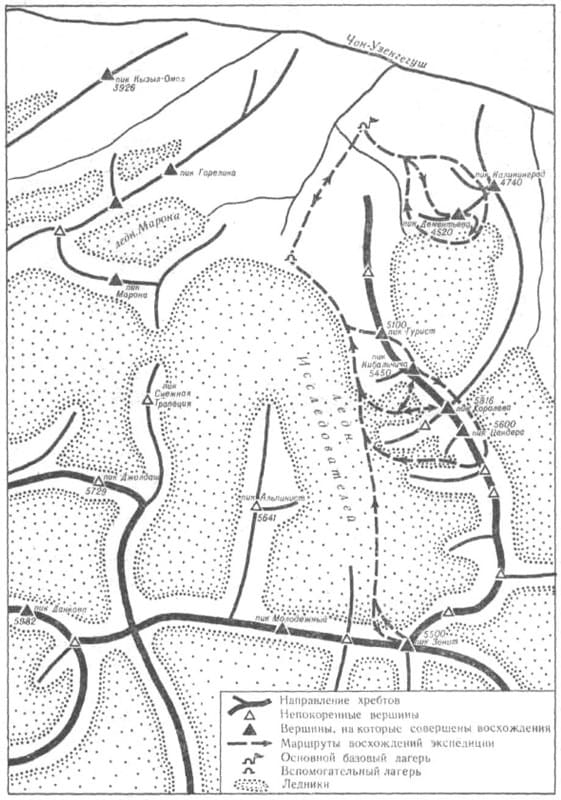
1933. The information from N. Palgov's expedition attracted the attention of climbers and tourists from the tourist section of the Moscow House of Scientists, who in the summer of 1933, during their vacation, went on the first tourist trip in this area, organizing it for scientific purposes, and also in the hope of making the first ascents there.
The detachment, whose work was organized by the Moscow House of Scientists in the period from August 1 to September 1, 1933. The route taken by the detachment is as follows: Karakol - Pokrovka village - Dzhuuku pass - Arabel tract - Jetym pass - Kara-sai valley - Chakyr-Korum pass - upper reaches of the Dzhegalamai river - Kara-chukur river - Kubergenty pass - Kyzyl-unet glacier (Komarova) - Aitala river - valley Dzhurek-nar - Chon-Uzengegush river then back through the Chakyr-korum pass - Tien-Shan Observatory - Kashka-su pass - Pokrovka - Karakol.
It was this expedition that gave the names to the main peaks of the region, including the Kyzyl-Asker peak. Here is how August Letavet describes his 3rd expedition to Tien-Shan and exploration of the western part of the Kakshaal-Too ridge (“Central Tien-Shan”. Physical Culture and Sport Magazine. No. 7. A. Letavet. 1937):
“We discovered another very interesting group of peaks in 1933, in the upper reaches of the Grigorieva Glacier, which we first described. The peak that closes the western branch of this glacier, with its contours strongly resembles one of the Himalayan eight-thousanders - Kanchenjunga.
This peak, more than 6,000 meters high, was then named by us as Academician O. Yu Schmidt Peak. On the eastern side of the Grigorieva Glacier there are two rocky peaks, very similar to each other - the Dzholdash peaks. Further to the east - on the Chon-Tura-su glacier there is a very beautiful rocky peak, sticking out like a huge fang in the very middle of the glacier.
It is not connected to the surrounding mountain ranges in any way. We called this very graceful peak Alpinist Peak (about 5500 meters above sea level). Climbing all the peaks of this group is associated with overcoming very great technical difficulties, and victory over them will be a great victory for the technology of young Soviet mountaineering.
The Uzengegush group of Kakshaala is undoubtedly the most interesting mountain range of the Central Tien-Shan in terms of mountaineering. Already from the Kubergenty Pass, a grandiose and severe panorama of the six-thousanders of this region opens up.
Here there is a whole series of powerful glaciers (the glaciers of Komarov, Fersman, Grigoriev, etc.), explored and described partly by Polgov, partly by me together with Nemytsky. The series of six-thousanders opens with the westernmost of the peaks of this region - the grandiose peak Krasnoarmeyets, which in 1934 we named so because from afar its contours really do resemble a soldier standing guard.
At that time, we tried to climb it. However, we managed to overcome only a small part of the first icefall, since the severe bad weather that broke out forced us to turn back. The 1933 expedition included Professor V.V. Nemytsky, K.S. Letavet (wife of A.A. Letavet), V.K. Goltsman and M.M. Goltsman.
1933 – 1934. Tourists from the Moscow House of Scientists also took an active part in studying the area. Under the guidance of Avgust Andreevich Letavet (1893-1971), they visited and described the glaciers of the central part of the ridge in the area of Dankov Peak in 1933 - 1934. Letavet gave names to these glaciers (Palgov and Grigoriev glaciers in honor of famous geographers). He also named the peaks of the area - the peaks of Kyzyl-Asker (Krasnoarmeets), peaks Dzholdash, Schmidt, Alpinist.
1934. 4th expedition of August Letavet to Tien Shan. The Uzenhigush group of the Kakshaal-Too ridge was explored. An attempt was made to climb the highest point of the group, Krasnoarmeyets Peak. During this expedition, Alpinist Peak (Chon-Turasu group) was discovered.
In the upper reaches of the Chon-Turasu River, the first sport ascent to a peak 4900 meters above sea level was made, later named in honor of one of the climbers, Maron.
1935 - 1937. In the interval between the mountaineering expeditions of A. Letavet, 1934 and B. Simagin.
1938. The Department for the Protection of Subsoil Use of the Kirghiz SSR conducted a geological survey of the area where the Komarova Glacier is located (glaciers 78 (Komarova) - 81).
1938. The first and only purely mountaineering expedition of the Krylia Sovetov sports society, led by B. Simagin, headed to the western part of the Kakshaal-Too ridge until 1969. The attempt to storm the peak, which they called Krylia Sovetov, ended unsuccessfully due to bad weather.
1956 - 1957. Tourist groups led by E. Kazakova and B. Rukavishnikov, in 1956-1957, completed a task that interested many travelers - they finally reached the Uzengegush breakthrough through Kakshaal-Too.
1957 - 1960. A huge amount of work on determining the orography of the northern spurs of the ridge was done by tourists from MIPT and the Burevestnik Sports Society of Moscow and Leningrad. In 1957-1960, separate groups and complex tourist expeditions under the leadership of A. Berlyand, P. Zarubin, E. Chasov, E. Ivanov systematically studied the region.
About 20 first ascents to the observation peaks of the region were made, several passes through the main ridge and its northern spurs were discovered. E. Chasov compiled a detailed orographic map of the region.
Geographic coordinates of western part of Kakshaal-Too ridge: N41°01'49 E77°13'44
Authority:
"Research of glaciers in the USSR" 1935, issue 2 - 3 under the title "New data on glaciation in the Chakyr-Korum, Borkoldy and Kok-shaal ridges" (authors - A. Letavet, V. Nemytsky).
"On the glaciers and peaks of Central Asia", Dmitry Zatulovsky, Moscow, OGIZ-Geografgiz, 1948.