







Вы здесь
Glaciation in Big Almaty Gorge.
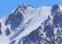
Glaciers in Big Almaty River valley.
"The accumulation period in the glacier tongue zone lasts from mid-September to early July (about 9 months); in the firn field zone, it extends to 10 months or more per year. During the accumulation period within the glacial zone (at elevations of 3,300-3,600 m), the long-term average air temperature is minus 7-9°C."
Central and Southern Kazakhstan. Issue 2. Lake Balkhash Basin. Part 7. Tentek and Rgayty Rivers. Gidrometeoizdat. Leningrad. 1969.
A hike across glaciers in Big Almaty Gorge.
The glaciers of the Big Almaty River basin are located in the upper reaches of the Big Almaty River valley. The Big Almaty River consists of two branches. The left (western) branch is known as the "Prokhodnaya." The right (eastern) branch bears the name " Big Almaty."
Glaciers in upper reaches of Prokhodnaya River valley.
The Prokhodnaya River valley is bordered by the Kargaly Spur to the west and the Big Almaty Spur to the east. To the south and southeast, it is enclosed by the main ridge of the mountain range, which trends northeastward in this area. Small-scale glaciation is observed in the side gorges and cirques.
A total of fourteen glaciers are found here. Of these, eight are located on the western (Kargaly) spur, including two debris-covered glaciers with a combined area of 3.7 km. sq., five are located on the main ridge with a total area of 3.2km. sq., and one, with an area of 0.3 km. sq., is situated on the western slope of the Bolshaya Almatinka spur.
None of the glaciers have individual names. P. A. Cherkasov designated them all - with the exception of the buried ones - by numbers ranging from 1 to 12. In terms of type, they are classified as cirque and hanging glaciers, as well as - to some extent - hanging-valley and slope-apron glaciers; there are no valley glaciers among them.
Glaciers No. 3, 11, and 1 stand out due to their larger size. The total area of all glaciers in the Prokhodnaya River basin, including firn fields and buried sections, is 7.2 km. sq.
Glaciers in headwaters of Big Almaty Gorge.
The basin of the right branch of the Big Almaty River extends deep into the main ridge of the Zailiysky Alatau. The extent of glaciation here is significantly greater than in the headwaters of the left branch. Four glacial groups, more or less distinct from one another, can be identified in this area.
The first group is located on the slope of the main ridge, between the western lateral spur and the river's main headstream. This section of the main ridge does not exceed 4,000 meters in elevation. For the first 7 km from the west, it has a northern aspect; subsequently, as its axis turns southward, it takes on an eastern aspect.
The northern slope of the ridge drops steeply into a wide valley filled with ancient moraine deposits. This valley originates at the saddle of a lateral spur that separates the basin of the river's left branch from that of its right branch. At one time, the saddle was occupied by a transfluent glacier; today, moraine deposits lie in its place.
Six glaciers, ranging from 0.5 to 1.5 km in length, are situated in short, steep ravines along the northern slope of the ridge - a ridge that reaches a peak elevation of 4,243 m but averages no more than 4,000 m. With the exception of one, their termini do not reach the valley floor.
The single glacier that does descend into the valley is notably longer (up to 2 km); it is located near the point where the ridge turns southward. Throughout its middle and lower reaches, it is covered by a continuous layer of moraine deposits. This covering has enabled it to withstand the retreat affecting other glaciers; beneath the moraine, it slowly advances. It sits as a massive, high ridge amidst the valley's old, overgrown hills.
Due to this distinctive appearance, the glacier has been named "Moraine" (Morenny). The section of the main ridge that curves southward, with its slope facing east, supports five cirque and hanging glaciers. The total area of the first group of glaciers does not exceed 7 sq. km.
The second group of glaciers is located in the southeastern part of the basin. Some peaks here rise to 4,400 m or higher. The slope is deeply incised by wide ravines, some of which are well-developed cirques.
Thanks to the high elevation of their firn fields, the glaciers of the second group are the most significant in the river basin.
The glaciers of the second group have been thoro
Perevalny;
Cherny;
Skalisty;
Glavny (Main), with the "Krutoloby" lateral tributary.
History of glacier research in Big Almaty basin.
Systematic scientific study of the glaciers of the Zailiysky Alatau began in the early XXth century. One of the first researchers of modern glaciation in this mountain region was Sergey Yevgenyevich Dmitriev (1861-1931), who began observing glaciers in the vicinity of Verny in 1902.
Initially, his focus was on the Tuyuksu glacier basin in the upper reaches of the Small Almaty River, but his research later expanded to other areas of the Northern Tien-Shan. Dmitriev’s work laid the foundation for subsequent systematic studies of the Zailiysky Alatau glaciers.
Later, the study of glaciation was continued by local researchers and specialists from the Academy of Sciences of the Kazakh SSR. A prominent figure among them was Pyotr Alexandrovich Cherkasov, who investigated glacier morphology, dimensions, and developmental characteristics. In 1955, he published a specialized study titled "Glaciers of the Western Part of the Big Almaty River Basin in the Zailiysky Alatau."
This work examined the glaciation of the basin's western section, including the Prokhodnaya River valley and specific glacier groups, analyzing their morphological features and topographic positioning. Cherkasov’s description is of particular interest due to its detailed characterization of small glaciers in the Kargalinsky and Big Almaty spurs, as well as glaciers along the main ridge.
The researcher focused not only on glacier dimensions but also on their structure, the extent of moraine cover, and their relationship to mountain landforms. For instance, one of the glaciers in the Prokhodnaya Valley was distinguished by a characteristic moraine cover that concealed a significant portion of the ice, giving the glacier the appearance of a large ridge amidst older moraine hills.
Due to this feature, it was named "Morenny" (Moraine Glacier). A new phase of research was associated with the International Geophysical Year (1957-1958) and subsequent activities. During this period, the study of mountain glaciation became more comprehensive: alongside glacier descriptions, researchers monitored ice movement, changes in the position of glacier tongues and surface elevation, and investigated snow and ice accumulation and ablation processes. Research findings regarding the Zailiysky Alatau were published in specialized collections by the Academy of Sciences of the Kazakh SSR during the 1960s.
The compilation of glaciation catalogs was of great importance for the continued study of glaciers. The *Catalog of Glaciers of the USSR: Central and Southern Kazakhstan*, published in 1967, marked a significant milestone in systematizing data on the region's glaciers.
Later, glacier characteristics were refined using aerial photography, cartographic data, and the results of follow-up studies. Comparing catalogs from different years made it possible to shift from describing individual glaciers to assessing changes in the overall glaciation of the Zailiysky Alatau’s northern slope.
For the Big Almaty basin, published data indicate a marked reduction in glacier area during the second half of the XXth and the early XXIst centuries. According to the catalogs, the total glaciated area in the basin decreased from 33.9 km² in 1955 to 18.08 km. sq. in 2008.
hen comparing these figures, it is necessary to take into account the specific glacier mapping and inventory methods used in different years. Modern research views the glacial formations of the Big Almaty basin not only as sources of river flow but also as vital components of the high-mountain natural system.
In particular, studies are being conducted on rock glaciers - landforms composed of ice and debris - examining their dynamics and their impact on water runoff. Such work complements traditional glacier monitoring and helps provide a more accurate assessment of changes in high-mountain water resources.
Thus, the history of research into glaciation in the Big Almaty basin mirrors the evolution of domestic glaciology: from the initial field descriptions of the early XXth century and the detailed morphological studies of the mid-century to systematic mapping, the comparison of long-term datasets, and modern investigations into glacial and rock-ice formations.
Authority:
Article "Glacial Structures of the Northern Tien-Shan – Zailiysky Alatau"
https://elib.rgo.ru/safe-view/123456789/226999/1/0LPQtdC+0LsuMjRfVGFsZ2FyLCBnbGF2bmF5YSB2ZXJzaGluYSBaYWlsaWlza29nbyBBbGF0YXUsIGJsaXoucGRm
Photos by:
Alexander Petrov.