


![]()
You are here
History of Big Almaty Lake.

Natural attractions in Big Almaty Gorge.
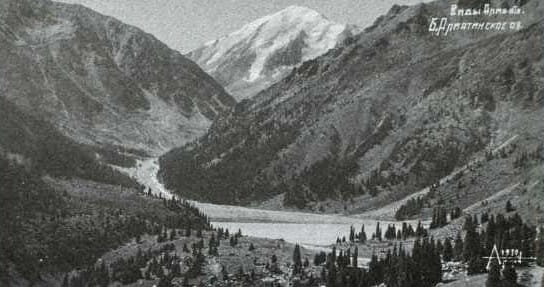
"Along this same route, somewhat to the east, on the northern slope of the Trans-Ili Alatau, 21 miles from Vernoye, lies Lake Almaty (8,192 feet above sea level), which, like many other lakes in the Semirechye mountains, is a moraine alpine lake. Lake Almaty (known to the Kyrgyz as Dzhasyl-kul - Green Lake) is approximately 1/3 of a square mile, with a maximum depth of 17.5 fathoms. The Dzhasyl-kul-su River (which forms the Bolshaya Almatinka River below) flows out of the lake in cascades, due to the damming of an ancient moraine that formed the lake."
"Turkestan Region." V.I. Masalsky. 1913.
Hiking and recreation at Big Almaty Lake.
The lake was previously called Zhosalykol, then briefly in the early XXth century, Almaty Lake. It later acquired its current name, which reflects its location in the Big Almaty River basin. The lake's dam was formed by an ancient glacial moraine, creating a natural dam.
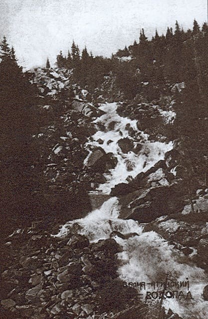
Until the late 1940s, a river with beautiful cascading waterfalls flowed out of the lake over the top of the natural dam. In the early 1950s, the river flowing out of the lake was partially diverted into a pipe, feeding water to the turbine blades of a cascade of hydroelectric power plants.
A horse trail from the town of Verny crossed the lake to the Ozerny Pass, the easiest route to the Big Kemin Valley (in Kyrgyzstan). Above the lake were the favorite summer pastures of the Kazakhs, the dzhailau, whose grazing was only closed in the 1960s.
In 1908, Verny hydraulic engineer and local historian A. Vinokurov published an article about the lake in the Moscow collection "Geography." It is noteworthy that the author considers the lake merely as a source of water for irrigating the foothill fields, without mentioning its aesthetic value.
Residents of Verny made excursions to the lake, admiring the beautiful cascade of waterfalls flowing through a natural dam, overgrown with spruce forest and interspersed with huge rock fragments along the slope. (This cascade is now diverted into a pipe supplying water to the first hydroelectric power station.)
Interestingly, the lake was considered less accessible than Issyk Lake, which is located much further from the city. In the late 1970s, the natural dam was reinforced with reinforced concrete, and in the 1980s, periodic repairs were carried out by "Kazglaselezashchita".
Authority:
A. Lukhtanov. "City of Verny and Semirechensk Region." 2014.
Essay by Nikolai Nikitovich Palgov on Big Almaty Lake.
"Here the river valley is blocked by a huge dam of rocks and rubble. This is an ancient moraine, once deposited by a glacier that reached here from the snow zone. The glacier that formed it disappeared long ago due to global warming. Its remnants have moved up the valley and now lie at an altitude of 3,100 m or more.
The moraine that remains in place is densely overgrown with spruce forest and deciduous shrubs. Amid the greenery of the forest covering it, the river's waters cascade down the steep slope like a silver stream. With a resounding roar, they strike the rocks and rise in fine, dust-like spray.
This is the lower Big Almaty Waterfall, with a total drop of 150-200 m. The ascent to the ancient moraine is along a steep, narrow, corkscrew-like path. A horse carrying a load carries it with heavy with a choking snore. A little higher up, through the shaggy branches of the spruce trees, the emerald surface of Lake Zhasyl-kul (Green Lake), best known by its nickname "Almaty Lake," appears.
To circle it, you need to travel about 4 km. The waters of the lake, Greenish from suspended particles carried by the river, they rest among winding, picturesque banks. Green capes dissect them here and there, forming cozy bays. In clear, calm weather, the lake's smooth surface reflects the entire surrounding panorama: jagged, rocky peaks; forest clumps with meadow clearings; and a blue sky dotted with clouds.
The lake is quite young. It apparently didn't exist during Alexander the Great's campaigns in Central Asia. From almost any vantage point, one can see the part of the lake from which it is filled by river sediments. The shore on the other side is a flat, level river delta extending far across the valley, covered with damp, and in places, marshy meadows.
According to one researcher, the river delta grows by an average of 117 cm per year. This means that in 800-900 years, the lake will be completely displaced by sand and silt. Due to the uneven water inflow, the lake level rises and falls. It would be significant if the lake had no outlet.
But the crest of the moraine damming it is cut by a naturally formed channel through which the lake's waters flow as a waterfall. This second, upper waterfall is even more spectacular than the lower one. The lake is beautiful in the summer on clear, sunny days.”
Authority:
"The Nature of Kazakhstan in Essays and Pictures." N.N. Palgov. Publishing House of the Academy of Sciences of the Kazakh SSR. Alma-Ata. 1950.


Photos 5, 8, 10 are taken from the website:
https://starinariy.kz/