


You are here
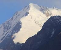
Glacier of Gando.
Hiking trip on Pamir mountains in Tajikistan.
“... I smoked for a long time over the snowy abyss,
Now I could not help but understand:
The night, my beloved, sleeps serenely
But mother secretly prays"
Yuri Vizbor. December 1954.
Mountain hiking Pamir mpuntains Tajikistan.
Gando glacier is located at an altitude of: upper limit of 6785 (Moscow peak) and 6446 (Abalakov peak) meters above sea level, end of glacier is 3518 meters above sea level, glacier is located between northern slopes of Garmo ridge and southern slopes of Peter Great ridge, on territory of Tajik National park, in Tavildara district, Republic of Tajikistan.
The length of the glacier is 22.0 kilometers, the area is 44.6 square kilometers, located in a relatively narrow longitudinal basin between the Peter the Great ridges and its large spur in the east, in the eastern part of the Garmo ridge - the OPTE ridge (Society of Proletarian Tourism and Excursions (OPTE) ( All-Union Voluntary Society of Proletarian Tourism and Excursions) is a voluntary society that appeared on March 8, 1930 as a result of the merger of JSC "Soviet Tourist" and the Society of Proletarian Tourism (OPT)).
The Gando Glacier belongs to the Obihingou River basin. In the west, the basin has access to the valley of the Kyrgyzob River, through which moisture is delivered by western and southwestern air currents, and the ridges that close it form a high barrier on their way, causing heavy precipitation.
The main flow of the Gando glacier has a complex multi-chamber feeding area at the junction of the Peter the Great and SPTE ridges (Society of Proletarian Tourism and Excursions). On the northern slope of the OPTE ridge there is a vast firn region of the Dorofeev glacier, the main left tributary of the Gando glacier.
History of exploration of Gando Glacier.
Part of the Gando glacier fills almost the entire bottom of the basin, its width gradually decreases: from 2 kilometers in the upper reaches to 500 meters in the lower part. Median moraines, formed by the merger of the main components, form loops in the middle part of the glacier, characteristic of pulsating glaciers.
Perhaps the Dorofeev glacier is pulsating. According to the testimony of the participants of the 1931 expedition, this glacier was connected with the Gando glacier by “a huge ice element, which at the same time distorted itself” (“Five Years in the Pamir mountains.” 1935. P. 68).
In 1948, this section was relatively easy to pass (Timashev. 1949). For 8 - 9 kilometers from the end of the Gando glacier, the moraine forms an almost continuous cover. There is a hilly and cellular topography with rounded basins filled with water and gentle hills.
The lower 2 - 3 kilometers of the end of the glacier are heavily destroyed by water flows. In addition to the Gando glacier and its tributaries, there are 24 more glaciers in the basin, and the total glaciated area of the basin is 58.2 square kilometers.
Geographic coordinates of Gando Glacier: N38°54'58 E71°48'00
Authority:
"Glaciers." L.D. Dolgushin, G.B. Osipova. Series "Nature of the world." Moscow, the publishing house "Thought". 1989.
Photos by:
Alexander Petrov.