


![]()
You are here
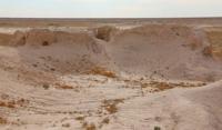
Ancient settlement Tompak-asar.
Excursions along Silk Road of Kazakhstan.
"History likes to repeat itself"
Thucydides.
Kazakhstan and Central Asia.
The settlement Tompak-asar is located in the Karmakchinsky district of the Kyzylorda region, 28.9 kilometers to the west and slightly north of the village of Turmaganbet and 57.9 kilometers to the south-west of the regional center of Zhosaly.
Its oval top platform, measuring 75 x 60 meters, 11.5 meters high, from the north, east and south, was covered by a second platform, also round in shape, up to 3 meters high. In 1979 - 1981 and 1983 - 1984, this settlement was excavated by members of the expedition (see the author's reports in the archives of the Institute of Economics and Science of the Russian Academy of Sciences and the Academy of Sciences of Kazakhstan).
The excavations covered almost two thirds of the upper site (excavations of the Ist - IVth centuries) and the northern and eastern sections of the second site (excavations of the Vth - VIIth centuries), revealing the complex stratigraphy of the site with its 11 building horizons and numerous restructuring within each of them, spectacular residential and fortifications.
Excavations of early Dzhetyasar settlements showed that inside the fortress walls of a high central platform-tier, a pakhsy base was built, at least 1.5 - 2 meters high. At the Tompak-asar settlement, basement structures under the internal buildings were erected strictly taking into account the layout of the lower building horizon, when a pile of 2 - 3 horizontal rows of bricks was laid on the original platform for certain rooms, corridors, on top of which brick walls were erected and floors were plastered (like, for example, for rooms No. 102 - 106, 108 - 112 of excavation I, for rooms No. 26 - 27 of excavation IV, No. 36 of excavation II).
The pits also helped to reveal the layered nature of the original platform itself, where hard brick layers alternated with much softer, finely lumpy clayey or loamy fillings in the central part of the fortress. At the same time, under the inner "courtyard" an additional brick podbutovka was fixed only along the walls to a width of 1.2 meters, obviously, under the "ayvan" part of the "courtyard".
Under the entrance and pre-entrance complexes of the northern section of the Tompak-asar settlement, as well as under its attached corridors, the basement had a different character. It was a dense platform of lumpy large pieces of clay and fragments of bricks that filled special substructure cages.
The walls of the cages are made of bricks, which differ sharply in quality from the raw bricks in the wall masonry and resemble very dense small pahsa blocks, on which clear finger marks have been preserved. The east tower had the same substructure stand system.
There were no foundations under the residential buildings of the second site on various monuments. The buildings of the later building horizons were erected on muddied premises with cut walls of the lower building horizons on top of a special brick layout.
Fortifications (towers, shooting corridors), attached to the earlier walls, were erected on high platforms of pakhsa and rows of adobe bricks laid with regular masonry, but without mortar. At the same time, bricks of different sizes and thicknesses were most often used in different rows, alternating rows of bricks of normal thickness and thin ones (although there were also deviations from this rule).
Jetyasar settlements, as mentioned above, are represented only by well-fortified settlements.
Fortifications were, obviously, one of the main concerns of the inhabitants of the Djetyasar fortresses. The earliest fortifications known to us are represented by powerful high walls with a significant slope from the outside to the base of the walls due to the wider lower part.
In terms of plan, these fortifications had the shape of an oval or a circle, less often a rectangle with strongly rounded corners and were devoid of outrigger towers. These walls were built with a combined masonry of low pakhsa blocks and mud bricks (standard 50 x 30 and 60 x 30 x 9 cm) with a certain block cut, which often created the appearance of masonry.
The fortress walls themselves had defensive corridors, erected according to a single plan with one floor level, the same vault, but blank compartments. If in the earliest corridors these compartments were relatively long, then later (probably already in periods 16, 1c, II) they were rather short premises covering from three to six loopholes.
Later, sub-rectangular in plan with rounded corners, outrigger towers with loopholes in three walls, similar to those known at the sites of Bedaik-asar and Tompak-asar, were added to the fortress walls on a high base.
Geographic coordinates of the ancient settlement Tompak-asar: N45 ° 06'56.68 "E63 ° 34'12.84"
Authority:
L.M. Levina. “Ethnocultural history of the Eastern Aral Sea region. 1st millennium BC -1 millennium AD ". 1996 year. Publishing house "Eastern Literature".
Photos by
Alexander Petrov.