You are here
Burials of Uygarak.


Jeep safari in Kyzylorda region.
"Man has power over the past, present and future"
Alexander Sergeevich Grin.
Description of routes of Kyzylorda region.
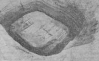
Burials of Uygarak are located in the Karmakshinsky district of the Kyzylorda region, 83.5 kilometers south-west of the Zhanadarya village and 60 kilometers south and slightly west of the Akkyr village, in the vicinity of the Uygarak hillock, 120.1 meters above sea level.
For a number of years the Khorezm expedition has been working on this problem in the lower reaches of the Syr Darya. The studied sites cover the period from the 7th century. BC. until the first centuries A.D. The earliest of them, dating back to the VIIth - Vth centuries. BC, are represented by burial grounds on the Tagisken and Uygarak hillocks, the distance between which is 17.9 kilometers.
At Uygarak, 70 burial mounds have been excavated. The similarity of the burial ritual, observed in the analysis of the burials of both burial grounds, makes it possible to classify them as closely related ethnic groups, which makes it possible to consider the materials of the burial grounds in a single complex.
On Uygarak there is another category of ground graves (12), which are not found in Tagisken, but which belong to the same chronological period. These are narrow, rectangular graves with rounded corners, in some cases almost oval.
Structurally, they are similar to the above-described burials in large ground pits by the presence of an overlap of poles and branches. Thus, for the VII - VI centuries. BC. we have three types of burial structures, while the funeral ritual is the same in all cases when it was possible to fix it.
The deceased was laid stretched out on his back on a bedding or stretcher (Uigarak) made of reeds or wooden poles. Sometimes the deceased was covered with a reed mat on top. The dead are always oriented with their head to the west with a deviation to the southwest, less often to the northwest.
The preservation of the western orientation is another fact indicating a genetic link with ancient burials of the Bronze Age. The 5th century burial mounds on Uygarak do not stand out constructively in any way, and the set of things from them is not very expressive.
But on Tagisken, a group of rich burials of the Vth century is very clearly distinguished. BC. The construction of these graves is characterized by the presence of a dromos (length 5 - 12 meters), oriented in most cases to the southeast.
The structure of the grave pit is the same as in the barrows of the VIIth - VIth centuries. BC, but it is usually quite deep (2.2 - 2.3 meters). A significant difference is the other orientation of the deceased, lying with his head to the east-northeast.
The pit is usually oriented at the corners to the cardinal points, and not by the sides, as in the earlier mounds. The buried lie stretched out on their backs, sometimes diagonally across the pit, their legs bent at the knees and facing inward with their feet, forming a rhombus in plan.
But this posture is not always equally well defined. The grave pits and dromos (partially) had flat ceilings, and here there were also cases when the ceiling was set on fire, and then a mound was poured. One of the kurgans (No. 59) was a ground structure of the type of ground pits with dromos, from which only traces of post pits have survived.
This type of buildings is apparently close to the structures discovered by K.A. Akishev in Besshatyr. Thus, for the mounds of the 5th century. BC. the preservation of pits at the corners of the burial pit is still characteristic, the coexistence, albeit as an exception, of ground pits and ground burial structures, the significant role of fire in the burial ritual.
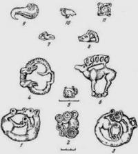
All objects of art found in the Uygarak mounds include the Saks of the Aral Sea region in the area of the Scythian animal style.
Geographic coordinates of the Uygarak burial ground: N44 ° 14'11.12 "E63 ° 53'05.05"
Authority and photos:
http://kronk.spb.ru/library/vishnevskaya-itina-1971.htm
O. A. Vishnevskaya, M.A. Itina. "Early Saki Priaral" I. MIA No. 177. Moscow, 1971. Pp. 197 - 208.


