


![]()
You are here
Ancient settlement of Yakke Parsan.
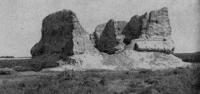
Photo tours along Silk Road of Karakalpakstan.
“One gets the impression that these are monuments of different nations. If we followed the tradition characteristic of bourgeois archeology, explaining all any significant changes in culture by migrations of peoples or borrowings, we would have to draw such a conclusion. However, a deeper study leads to completely different conclusions. Before us is not the culture of two peoples, but the culture of two socio-economic formations, the culture of one people at two stages of its historical development."
S. P. Tolstov.
Tour to Aral Sea in Karakalpakia.
The Yakke Parsan settlement is located 9 kilometers to the west and slightly north of the Bilkum sands, 14.5 kilometers to the east and slightly north of the Shark Yulduz village, 6.8 kilometers to the west and slightly south of the Kyrkkyz village, 13.1 kilometers to the north-east of the village of Ellikala in the Ellikala region of the Republic of Karakalpakstan.
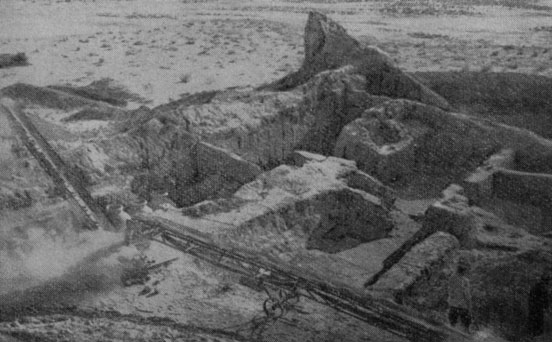
In 1940, S.P. Tolstov discovered Yakke Parsan - one of the most interesting structures of the VIth - VIIIth centuries. In 1959, E. Ye. Nerazik, a researcher of Afrihid antiquities, began its excavations, with interruptions they continue to this day. In the center of the walled rectangle, a formidable donjon tower rises to a height of fifteen meters, in which living quarters are located on two floors.
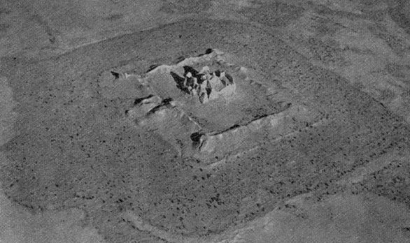
Yakke Parsan - the ruins of the classic example of the Khorezm castle of the pre-Islamic time; one of the most interesting buildings of the Afrigid era.
Its walls, corrugated in half-columns, in the conditions of the southern sun, created a magnificent light effect by alternating deep shadows and brightly lit areas. The defenses of the walls were reinforced with towers, two elongated oval towers flanking the entrance.
And, finally, all this was surrounded by a moat of such dimensions (its width initially exceeded 20 meters) that it seemed as if the castle was standing on an island in the middle of a square artificial lake. Excavations of the keep and utility rooms inside the walls showed that the castle existed from the Vth to the VIIIth centuries. and gave very interesting material for the study of the economy and culture of the population of the time of "tens of thousands of castles."
In addition to ceramics and animal bones, they found a lot of household crafts made of wood and bone, scraps of a wide variety of fabrics and carpets, and the remains of shoes. The most valuable find was a fragment of a document on leather, written in the ancient Khorezm language, shortly before the Arabic script spread in Khorezm and other states of Central Asia following the Arab conquest.
Almost everything that archaeologists had to face showed a completely different picture compared to antiquity. Gone is the magnificent red engobe pottery, replaced by rough, mostly made without a potter's wheel.
This indicated the decline of the craft. The brick standard has changed, it has become smaller in size and not square, but rectangular in shape. And even that was used little: the buildings were erected mainly from pakhsa - a solid adobe mass.
Of particular interest was the clearly traced by archaeologists for the Vth - VIth centuries. a sharp decline in irrigated areas. The decline of crafts, the general coarsening of the culture of the sedentary agricultural peoples of Central Asia was strongly influenced by the massive movements of the steppe tribes that lived on the outskirts of the agricultural world that took place at that time - first to the northeastern neighbors of Khorezm, the Hephthalites ("White Huns"), then the Turks.
Having conquered the highly cultured, agricultural regions of Central Asia, these tribes created extensive but fragile state associations, which disintegrated after the very first serious shocks. However, neither high art nor millennial culture die at all; only the circle of people employed in the field of artistic craft and art is significantly reduced, and they themselves become only the property of the aristocrats.
It would be wrong to explain the decline of culture and crafts only by the conquests of the barbarians.
This is not even the main reason. Quite recently, in his last book devoted to research in Khorezm, SP Tolstov, comparing the culture of ancient and medieval Khorezm, wrote:
“One gets the impression that these are monuments of different peoples. If we followed the tradition characteristic of bourgeois archeology, explaining all any significant changes in culture by migrations of peoples or borrowings, we would have to do such a conclusion.
However, a deeper study leads to completely different conclusions. Before us is not the culture of two peoples, but the culture of two socio-economic formations, the culture of one people at two stages of its historical development."
Yakka parsan is similar to Teshik kaly in general planning technique: its premises, enclosed in a square of thick walls, surround a high square hall covered with a dome. The entrance to the castle, raised to the height of a monolithic pakhsy stylobate, was in the middle of the southwestern facade and was highlighted by a forward-peshtak portal, one of the oldest in Central Asia.
The castle stood in the middle of a large rectangular courtyard, surrounded by double walls with oval, far protruding towers. Two large towers in the middle of the southwestern front of the walls defended the gate, lying on the same axis with the portal and hall of the castle.
Another, also double wall, surrounded the estate at a distance of 9 meters from the first. The courtyard along the entire perimeter was encompassed by a strip of continuous residential development - merged cells of peasant dwellings, separated by parallel walls and equal depths on each side of the courtyard, left open only a narrow passage at the foot of the castle, which was reduced almost to nothing on the southeast side.
The Yakke Parsan courtyard was initially empty and was so conceived, and its construction with continuous quarters of peasant dwellings arose and spread later, and modest dwellings even penetrated into the narrow space between the double walls, thereby weakening their defensive power.
Geographic coordinates of the Yakke Parsan ancient settlement: N41 ° 55'16,00 "E61 ° 01'05,78"

Authority and photos:
https://ru.googl-info.com/8003541/1/yakke-parsan.html