


![]()
You are here
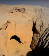
Ancient settlement Zhol-asar.
Cognitive journey across Kyzylorda region.
“Who knows that the first law of history is to be afraid of any lie, and then not to be afraid of any truth? It seems difficult to write history"
Sallust.
Photos of monuments of Kyzylorda region.
The Zhol-asar settlement is located in the Karmakchinsky district of the Kyzylorda region, 35.1 kilometers south-west of the Turmaganbet village and 71.1 kilometers south-west of the regional center of Zhosaly, west of the Asankara valley.
The settlement of Zhol-asar was described in detail by S.P. Tolstov, who assigned it to the first subtype of the first type of his classification (Tolstoye, 1948: 128 - 130). As it turned out as a result of repeated reconnaissance work, this is a badly destroyed characteristic two-tiered settlement, where the central oval platform, with an area of 45 x 35 meters, preserved to a height of 9.5 meters above the level of the modern surface, is surrounded by a low second platform of a circular shape.
On the central site, it was possible to fix a number of narrow rooms with a vaulted ceiling. The walls of the fortress and the interior were made of raw rectangular bricks in the plan, from 40 x 30 x 10 cm to 42 x 38 x 28 x 10 cm, as well as rows of narrow pakhsa blocks.
Geographic coordinates of the settlement of Zhol-asar: N45 ° 00'06.27 "E63 ° 29'55.11"
Authority:
L.M. Levina. “Ethnocultural history of the Eastern Aral Sea region. 1st millennium BC -1 millennium AD ". 1996 year. Publishing house "Eastern Literature".
Photos by
Alexander Petrov.