


![]()
You are here
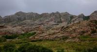
Arganaty mountain range.
Forwarding Kazakhstan tours.
“I am only afraid of bad weather in the mountains. This is the only thing in the mountains that does not depend on us."
Junko Tabei.
Tour around Karaganda region.
The Arganaty mountain range (Zhaksy-Arganaty) (Kaz. Arkanaty) is located in the north of the Ulytau district of the Karaganda region. The mountain range consists of hills stretching from north to south for 93 kilometers, width up to 15 kilometers.
The highest point of the mountains is Mount Dondygul, 757 meters above sea level. The slopes of the mountains gradually go down, turning into a plain. The northern part consists of Proterozoic rocks, the southern part consists of Devonian and carbonate rocks.
In the southeast, the ridge is adjoined by the small Basbaital mountains stretched from north to south, the Iolyk mountains adjoin from the south, the small Alaaygyr ridge, which has the highest mark, is Mount Akkoly 560 meters above sea level, from the south,
Numerous tributaries of the rivers Kara-Turgai, Sary-Turgai, Kara-Kengir, Terisakkan originate from Arganaty. In the west there are lakes Koskol, Kamystykol, in the east - Barakkol, Kurkol, Basbaital. There are many springs in the mountains.
Feather grass, fescue, wormwood, meadowsweet, and shrubs grow on the slopes of Arganaty. There are argali, saiga, wild boar, marmot; from birds - partridge and others.
Geographic coordinates of the Arganaty mountain range: N49 ° 20'23.96 "E67 ° 08'59.29"
Authority:
https://ru.wikipedia.org/wiki/%D0%90%D1%80%D0%B3%D0%B0%D0%BD%D0%B0%D1%82%D1%8B_(%D0%B3%D0%BE%D1%80%D0%B0)
Alexander Petrov.
Photos by
Alexander Petrov.