


![]()
You are here
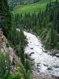
Bayankol river.
Popular destinations tourism in Kazakhstan.
“Travel to the best of your ability and free time, but above all in their home country - we still don’t know it properly”
Trip to Bayankol rivers from Almaty.
The Bayankol River is a right tributary of the Tekes River, its sources are located on the northern slopes of the Saryjaz ridge and on the western slopes of the Meridional ridge in the Narynkol district of the Almaty region.
The uppermost tributaries of the Bayankol river basin are the Sarykoinou and Karasai rivers. In turn, after the confluence of the Karasai River into Sarykoinou, the water flow is called Keksentas. The length of the Bayankol River is 60 kilometers.
The mouth of the river is located at an altitude of 1727 meters above sea level in the intermountain valley of the Tekes River east of the village of Koktobe. Actually, the beginning of the Bayankol River is considered to be the place where it flows into the Keskentas River on the left of the Ashutor River at an altitude of 2510 meters above sea level.
3.5 kilometers before the village of Narynkol, the Bayankol river splits into two channels and almost in the middle of the village the river converges again into one channel.
Sources of the Bayankol River.
Sarykoinou river.
The Sarykoinou River is 10 kilometers long. The river's sources begin from the central Bayankol glacier and the Western Bayankol glacier located on the northern slope of the Sarydzhaz ridge and from the glaciers of the western slope of the Meridional ridge, at an altitude of 3551 meters above sea level.
7.1 kilometers after the source, the Sarikoinou receives an unnamed tributary 4 kilometers long on the left. The tributary originates from the glaciers of the northern slope of the Katta-Ashutor ridge at an altitude of 3771 meters above sea level. The mouth of the stream is at an altitude of 2991 meters above sea level.
Geographic coordinates of the unnamed stream of the left tributary of the Sarykoinou: N42 ° 22'21.30 "E80 ° 09'20.78"
Several more streams are tributaries of the Sarykoinou, which the river receives from the eastern and western slopes. The upper border of the glaciers stretches from the Meridional ridge, along which the state border between the Republic of China and the Republic of Kazakhstan runs along the Sarydzhaz ridge to the Katta-Ashutor ridge.
The easternmost mark is in the Meridional ridge - 6146 meters above sea level (Plateau peak), followed by an altitude of 5450 meters above sea level in the Saryjaz ridge. The height of 5761 meters above sea level is also located in the Sarydzhaz ridge, followed by a peak at a height of 5437 in the Katta-Ashutor ridge along which the state border between the Kyrgyz Republic and the Republic of Kazakhstan passes. This is one of the most powerful glaciations in Kazakhstan.
Geographic coordinates of the Sarykoinou River: N42 ° 22'51.27 "E80 ° 10'15.95"
Karasai River.
3 kilometers after the confluence of the left unnamed stream into Sarykoinou at an altitude of 2888 above sea level in the vicinity of the Zharkulak mine, the Karasai River falls to the left. Karasai with a length of 6.8 kilometers originates at an altitude of 3788 meters above sea level from the northwestern tongue of the Karasai glacier.
The Karasai glacier is located on the northern slope of the Terskey Alatau ridge.
Geographic coordinates of the Karsai River: N42 ° 23'10.19 "E80 ° 07'29.39"
River Keskentas.
After the confluence of the Karasai River to the Sarykoinou River on the right, the river's waters get a new name - Keskentas. The length of the Keskentas River from the confluence of the Karasai River to the confluence of the left tributary Ashutor is 13.4 kilometers.
This section of the river is called Keskentas. Only 530 meters Keskentas flows without tributaries, soon an unnamed stream flows into the left. For 13 kilometers on the left, the river receives about 7 small tributaries-streams.
Geographic coordinates of the Sarykoinou River: N42 ° 22'51.27 "E80 ° 10'15.95"
Suryksai river.
6 kilometers after the confluence of the Karasai River into the Keskentas River, the Suryksai tributary with a length of 9.3 kilometers flows on the right. The source of the river starts from the northern tip Suryksay glacier located at an altitude of 3670 meters above sea level.
At an altitude of 3241 meters above sea level, the Suryksay receives the second tributary on the right. Three right tributaries of the Suryksai River originate from the glaciers of the western slope of the Meridional Range stretching from south to north.
The upper border of the glaciers is located in the crest of the ridge at an altitude of 4439 meters above sea level. On the left, Suryksai receives two tributaries. The first, upper tributary originates from the small Zharkulak glacier located on the northern slope at an altitude of 3692 meters above sea level.
In the southern part of the glacier, in the ridge crest located between the Keskentas and Suryksay rivers, there is the Zharkulak peak 4341.6 meters above sea level. The second tributary originates from the eastern part of the glacier tongue located at an altitude of 3669 meters above sea level.
The mouth of the Suryksai River is located at an altitude of 2720 meters above sea level.
Geographic coordinates of the Suryksai River: N42 ° 26'55.17 "E80 ° 09'35.53"
Right unnamed tributary on the Suryksai River.
3.7 kilometers after the confluence of the Suryksai into the Keskentas River, on the right, a small unnamed tributary with a length of 2.5 kilometers flows into it. The sources of the stream begin from the northern slope of the Suryksai mountain 3907.7 meters above sea level.
Geographic coordinates of the right tributary on the Suryksai River: N42 ° 28'59.78 "E80 ° 08'22.94"
Alaaygyr river.
4.7 kilometers after the confluence of the Suryksay River into the Keskentas, the Alaaygyr tributary with a length of 8.4 kilometers flows on the right. The sources of the Alaaygyr River begin from the lake of the same name located at an altitude of 3709 meters above sea level, from its southern end.
The lake is located on the western slope of the Meridional Range. The mouth of the river is located at an altitude of 2591 meters above sea level.
Geographic coordinates of the Alaaygyr River: N42 ° 29'44.36 "E80 ° 09'17.62"
Lake Alaigyr.
The lake is located on the western slope of the Meridional Range. The perimeter of the lake is 1348 meters. The area is 73015 meters above sea level. The length of the lake is 578 meters, the greatest width in the northern part of the lake is 284 meters.
630 meters south-west of the lake is the Alaaygyr pass 3870 meters above sea level. 170 meters to the south is the ridge of the Meridional Range, along which the state border between the Republic of China and the Republic of Kazakhstan passes.
There is another lake in the southwestern part of the lake, 65 meters to the west. The height of this lake is 3712 meters above sea level, the length is 142 meters and the width is 103 meters. At 407 meters to the north-east there is the next small moraine lake at an altitude of 3788 meters above sea level.
The outlines of the lake are very similar to the female profile, in which the head, hair, neck, chin are clearly visible, and the floating ice floe is the makeup.
Geographic coordinates of Lake Alaigyr: N42 ° 28'57.36 "E80 ° 12'56.20"
Ashutor river in Bayankol gorge.
The Ashutor River is a left tributary of the Keskentas River. The river is 20.4 kilometers long. The main sources of the river begin from the Western and Eastern branches of the Ashutor glacier located on the northern slope of the Saryjaz ridge.
The upper border of the glaciers is located at an altitude of 4636 meters above sea level. The source of the river begins from the Western Ashutor glacier located at an altitude of 3701 meters above sea level. One of the sources of the river from the Vostochny Ashutor glacier begins at an altitude of 3740 meters above sea level.
The left part of the Vostochny Ashutor glacier is swollen for 1200 meters. The mouth of the river is located at an altitude of 2525 meters above sea level. One of the left tributaries of the Ashutor River, originates from the eastern side of the Ashutor pass, 3933 meters above sea level, located on the eastern slope of the Terskey Alatau ridge.
1.7 kilometers after the source, Ashutor receives a small tributary on the right. 2.7 kilometers after the source, a small tributary adjoins on the left. At 5.2 km after the sources, another tributary adjoins on the right, and at 6.5 km, the tributary flows into the left.
An unnamed tributary of the Ashutor River №4.
At 10.3 kilometers, Ashutor receives an inflow from the left with a length of 5.6 kilometers. The tributary originates from the northern and eastern slopes of the Ashutor Novy peak, 4427.6 meters above sea level, which is located in the eastern part of the Terskey Alatau ridge.
Geographic coordinates of the unnamed tributary No. 4: N42 ° 27'30.87 "E80 ° 01'27.95"
An unnamed tributary of the Ashutor River №5.
At 12.5 km, Ashutor receives an unnamed tributary No. 5 on the right with a length of 3.5 kilometers. The tributary originates from small glaciers located on the northern slope of the Terskey Alatau ridge.
Geographic coordinates of unnamed tributary No. 5: N42 ° 27'08.83 "E80 ° 03'29.23"
An unnamed tributary of the Ashutor River №6.
At 13.7 kilometers, an unnamed tributary No. 6, 5.8 kilometers long, flows into Ashutor on the right. The tributary originates from the western slopes of Mount Denarcha 4013.1 meters above sea level and from small glaciers located on the northern slope of the Terskey Alatau ridge.
Geographic coordinates of the unnamed tributary No. 6: N42 ° 27'07.65 "E80 ° 04'26.23"
The geographical coordinates of the Ashutor River: N42 ° 27'51.82 "E80 ° 03'45.43"
Left tributaries of the Bayankol River.
Bugunysay river.
5.3 kilometers after the confluence of the Ashutor River, on the left, the Bugunysay River, 4.2 kilometers long, flows into the Bayankol River. Bugunysay originates on the northern slope of the Terskey Aatau ridge, partly from a moraine lake located at an altitude of 3431 meters above sea level.
The height of the ridge of the northern slope of the ridge is at an altitude of 3824.9 meters above sea level. The mouth of the river is located at an altitude of 2,418 meters above sea level.
Geographic coordinates of the Bugunisay River: N42 ° 32'19.51 "E80 ° 04'49.83
Izbushka river.
6.6 kilometers after the confluence of the Bugunysai into the Bayankol, the Izbushka River, 12 kilometers long, flows into the left. The Izbushka River is located between the Ashutor and Akkol rivers. It starts from the northern slope of the pass 3588 meters above sea level, the path through which leads to the upper reaches of the Ashutor River.
The left tributary of the river originates from two moraine lakes - Izbushka Vostochnoye and Izbushka Zapadnoye. The mouth of the Izbushka river is divided into three branches, the height at the confluence with Bayankol is 2285 meters above sea level.
Geographic coordinates of the Izbushka River: N42 ° 31'52.81 "E80 ° 02'08.55"
Lake Izbushka Vostochnoye.
Lake Izbushka Vostochnoye is located at an altitude of 3556 meters above sea level, located on the northern slope of the Terskey Alatau ridge. The lake looks like the letter Y and is located in the upper reaches of the river of the same name.
The length of the lake from the south-east to the north-west is 211 meters, the greatest width in the northern part is 160 meters. The perimeter of the lake reaches 659 meters, the area is 14780 square meters. In the southwest, the lake is bordered by a moraine, which descends into the lake in its northern part.
The northern shores of the lake are gentle, overgrown with plants of the alpine zone. Lake Zapadnoye is located 537 meters west of the East Lake.
Geographic coordinates of Lake Izbushka Vostochnoye: N42 ° 29'19.13 "E80 ° 01'59.60"
Lake Izbushka West.
Lake Izbushka Zapadnoye is located at an altitude of 3583 meters above sea level, located on the northern slope of the Terskey Alatau ridge. The lake is located in the upper reaches of the river of the same name.
The length of the lake from south to north is 136 meters, the maximum width is 154 meters. The perimeter of the lake reaches 516 meters, the area is 13683 square meters. In the north, the lake is bordered by a moraine, which adjoins the lake in its northern part.
The northern shores of the lake are gentle, overgrown with plants of the alpine zone. Lake Vostochnoye is located 537 meters east of West Lake.
Geographic coordinates of Zapadnoye Izbushka Lake: N42 ° 29'21.17 "E80 ° 01'36.66"
The second left tributary of the Izbushka River with a length of 2.5 kilometers originates from Lake Izbushka Nizhnee.
Lake Izbushka Nizhnee.
Lake Izbushka Nizhneye is located at an altitude of 3446 meters above sea level, located on the northern slope of the Terskey Alatau ridge. The lake lies in a narrow mountain gorge, from the north-western part of the lake flows a river.
The length of the lake from south to north is 270 meters, the greatest width in the central part is 221 meters. The perimeter of the lake reaches 877 meters, the area is 40440 square meters. A moraine descends from the western slope into the lake, the northern and eastern shores of the lake are overgrown with plants of the alpine zone.
Lake Akkol is located 5.2 kilometers in the northwest at an altitude of 3069 meters above sea level in the upper reaches of the river of the same name, which is the left tributary of the Bayankol River. 1.5 kilometers to the south and a little to the east is Lake Izbushka Zapadnoye, located at an altitude of 3583 meters above sea level in the upper reaches of the Izbushka River, the left tributary of the Bayankol River.
Geographic coordinates of Lake Izbushka Nizhnee: N42 ° 30'07.74 "E80 ° 01'17.71"
Akkol river in Bayankol gorge.
3.3 kilometers after Izbushka, another tributary flows into Bayankol on the left, this is the Akkol River. The Akkol River originates in the upper reaches of the gorge of the same name at an altitude of 3483 meters above sea level. The mouth of the river is located at an altitude of 2233 meters above sea level in the vicinity of the border outpost.
Lake Akkol in Baynkol garge.
In the upper part of the gorge, at an altitude of 3069 meters above sea level, there is Lake Akkol. The length of the lake from southwest to northeast is 658 meters, the greatest width in the central part is 314 meters. The perimeter of the lake reaches 2456 meters, the area is 210027 square meters.
Geographic coordinates of Lake Akkol: N42 ° 29'26.86 "E79 ° 57'35.66"
1.3 kilometers below the lake, the 5.5 kilometers long Kaskabulak tributary flows into the Akkol River on the right. The sources of Kaskabulak are located on the western slope of the Akkol gorge at an altitude of 3479 meters above sea level. The mouth of the Kaskabulak is located at an altitude of 2954 meters above sea level.
Geographic coordinates of the Kaskabulak tributary: N42 ° 28'28.36 "E79 ° 58'19.45"
The forest zone in the Akkol gorge is located up to an altitude of 2861 meters above sea level.
Geographic coordinates of the Akkol River: N42 ° 34'13.79 "E79 ° 59'47.65"
Chugunsai river.
3.3 kilometers after the confluence of the Akkol River into Bayankol, a small river Chugunsay, 8.5 kilometers long, flows on the left. The sources of the river are located on the northern and eastern sides of an unnamed mountain 3693.3 meters above sea level. 1.8 kilometers after the headwaters, the Chugunsai River receives a tributary on the right.
The mouth of the river is located at an altitude of 2,170 meters above sea level.
Geographic coordinates of the Chugunsai River: N42 ° 36'53.59 "E79 ° 57'11.26"
Charynbai river.
2.5 kilometers after the confluence of the Chugunsai, another tributary of the Charynbay, 6.2 kilometers long, flows into the left. The sources of the river begin from the eastern ridge of the watershed ridge between the Ulken-Kokpak and Bayankol rivers.
560 meters before the confluence with Bayankol, Chugunsay on the left receives an inflow with a length of 3.1 kilometers. The mouth of the river is absent, since the river bed is laid along a man-made canal that runs along the left slope of the Bayankol gorge.
Geographic coordinates of the Charynbay River: N42 ° 38'30.77 "E79 ° 57'47.27"
Right tributaries of the Bayankol River.
Bodobeksay river.
After 2.5 kilometers after the confluence of the left tributary of the Ashutor, the small river Bodobeksay with a length of 4 kilometers flows into the Bayankol River on the right. The river originates from the northern end of the Meridional Range at an altitude of 3283 meters above sea level. The mouth of the river is located at an altitude of 2489 meters above sea level.
Geographic coordinates of the Bodobeksay River: N42 ° 31'59.73 "E80 ° 08'18.18"
Asylbek river.
1.5 kilometers after the confluence of Bodobeksai into Bayankol, the Asylbek stream, 4.2 kilometers long, flows into the right. The main channel of the stream is formed at an altitude of 2927 meters above sea level from two sources. The left source starts from the Otabay valley at an altitude of 3078 meters above sea level. The right source originates at an altitude of 3366 meters above sea level.
Geographic coordinates of the Asylbek River: N42 ° 32'50.66 "E80 ° 07'23.08"
Bayteli river.
After 2.3 kilometers after the Asylbek stream, the Baiteli river, 5 kilometers long, flows into the right. The sources of the river begin from the western slope of the watershed ridge of the Narynkol and Bayankol rivers.
Basically, the river bed is formed at an altitude of 2698 meters above sea level from two tributaries. The left source is located at an altitude of 3054 meters above sea level. The right tributary originates from the Itayansay tract at an altitude of 3260 meters above sea level.
n the dominant ridge of the ridge in the vicinity of the right and left sources, there is a peak 3224.9 meters above sea level. The mouth of the Bayteli River is located at an altitude of 2382 meters above sea level.
Geographic coordinates of the Baiteli River: N42 ° 34'03.30 "E80 ° 06'34.02"
Shirokiy Stream.
1.5 kilometers after the confluence of Bayteli, the Shirokiy stream flows into Bayankol on the right length of 4.5 kilometers. The main channel of the stream is formed at an altitude of 2619 meters above sea level. The sources of the right stream begin at an altitude of 3079 meters above sea level from the western slopes of the Shirokiy pass, 3271.8 meters above sea level.
The Shirokiy Pass is a watershed between the Tungushpai and Baimensai rivers. The left tributary originates from the western slope of the watershed ridge at an altitude of 3163 meters above sea level. The mouth of the river is located at an altitude of 2360 meters above sea level.
Geographic coordinates of the Shirokiy brook: N42 ° 35'05.33 "E80 ° 05'09.10
Tungushpai river.
11.4 after the confluence of the Shirokiy stream into Bayankol, the Tungushpai stream 8 kilometers long flows into the right. The sources of the stream begin at an altitude of 2777 meters above sea level in the Tungushpai tract and on the north-western side of the Shirokiy pass, 3271.8 meters above sea level.
The mouth of the Tungushpai River is located at an altitude of 2142 meters above sea level.
Geographic coordinates of the Tungushpai River: N42 ° 37'08.25 "E80 ° 02'13.18"
Baymensay river.
630 meters after the confluence of the Tungushpai into Bayankol, another stream 9 kilometers long flows into the right. The sources of the stream begin from the northern side of the Shirokiy pass, 3271.8 meters above sea level. 6.2 kilometers after the source of the Tungushpai, on the right, the first tributary, 2.6 kilometers long, adjoins the stream.
The first tributary originates from the northwestern side of an unnamed mountain 3105.8 meters above sea level. After 400 meters, a second tributary with a length of 2.8 kilometers flows into Baymensai on the right.
The second tributary originates from the southern side of the Karagailysay pass 2752 meters above sea level. The mouth of the Baymensay stream is located at an altitude of 2130 meters above sea level.
Geographic coordinates of the Baimensai River: N42 ° 38'10.16 "E80 ° 01'24.19"
Aktas river.
After 12.7 kilometers after the confluence of the Baymensai, Bayankol receives the Aktas tributary with a length of 14 kilometers on the right. Aktas originates from the northern slopes of the Meridional ridge at an altitude of 3500 meters above sea level, from the western slope of the Koyshebulak pass at an altitude of 2949 meters above sea level.
When entering the intermountain plain, Aktas cuts through the Sarykaptal mountains, which the Bayankol river bends from south to north and further to the east. The mouth of the Aktas is located 3.7 kilometers below the village of Karatogan, at an altitude of 1909 meters above sea level.
Geographic coordinates of the Aktas River: N42 ° 39'27.55 "E80 ° 04'05.31"
Akbulak river.
The Akbulak stream, 5.5 kilometers long, does not reach Bayankol; on the intermountain plain, the stream's waters are disassembled for irrigation. The sources of the stream begin from the northern slopes of the Sarykaptal ridge.
Geographic coordinates of the Aktas River: N42 ° 41'30.94 "E80 ° 06'46.11"
Narynkol river.
The last right tributary of the Bayankol River is the Narynkol River with a length of 27.3 kilometers. This is the longest tributary with right tributaries in the Republic of China, left tributaries in the Republic of Kazakhstan.
After the confluence of two tributaries at an altitude of 3077 meters above sea level, the main channel of the Narynkol River is formed. The left source is the most abundant, it originates from a group of four glaciers located on the northern and eastern slopes of the Meridional Range and five lakes.
The upper border of the glaciers is located at an altitude of 4227 meters above sea level. On the left, the Narynkol River receives 6 tributaries, three of these tributaries have names, the rest are unnamed. The border of the forest in the gorge of the Narynkol River ends at an altitude of 2955 meters above sea level.
The mouth of the Narynkol River is located in the northwestern part of the Narynkol village at an altitude of 1808 meters above sea level.
Geographic coordinates of the Narynkol River: N42 ° 37'20.40 "E80 ° 09'51.49"
The lakes at the headwaters of the river are located on the eastern slope in the upper reaches of a narrow gorge, two of them are large and three are small.
Lake Narynkol Verkhnee.
This lake is located at an altitude of 3548 meters above sea level at the end of a 1.1 km long moraine that descends from the southwestern slope of a closed gorge, from the crest of a ridge. The highest point of the ridge is located at an altitude of 4227 meters above sea level. In the depths of the moraine, there is a glacier that feeds the Upper Lake Narynkol.
The length of the lake from southwest to northeast is 590 meters, the greatest width in the central part is 380 meters. The lake area is 156379 square meters, the perimeter of the lake is 1675 meters. A stream flows out of the eastern part of the lake, which after 400 meters flows into the Lower Lake Narynkol located at an altitude of 3412 meters above sea level.
Geographic coordinates of the Upper Narynkol lake: N42 ° 30'58.73 "E80 ° 12'11.81"
Lake Narynkol Lower
The lake is located at an altitude of 3412 meters above sea level, located in the upper reaches of the left sources of the Narynkol River. The lake is located 400 meters east of the Narynkol Upper Lake. On the western side of the lake is the mouth of a stream that flows out of the Upper Lake.
A stream overflows from the southwestern part of the lake and after 1 kilometer flows from the left into the left source of the Narynkol River. Two small moraine lakes are located 240 meters north-east of the lake. The highest point of the ridge ridge, in the vicinity, is located at an altitude of 4227 meters above sea level.
In the depths of the moraine lies a glacier that feeds the Lower Lake Narynkol. The length of the lake from southwest to northeast is 266 meters, the greatest width in the central part is 190 meters. The area of the lake is 39005 square meters, the perimeter of the lake is 835 meters.
Geographic coordinates of Nizhny Narynkol lake: N42 ° 30'58.73 "E80 ° 12'11.81"
The left source, 4.1 kilometers long, originates from glaciers located on the northern slopes of the Meridional Ridge. The highest point of the glaciers in the eastern part of the ridge located at an altitude of 4099 meters above sea level.
The state border between the Republic of Kazakhstan and the Republic of China runs along the left source. After the confluence of the left source with the right source, the river is called Narynkol.
First left unnamed tributary of the Narynkol River.
2.6 kilometers after the formation of the main channel, an unnamed tributary with a length of 3.6 kilometers flows into the Narynkol on the left. The sources of the tributary begin from two small glaciers on the northern slope of the Meridional Ridge.
Geographic coordinates of the first left tributary of the Narynkol River: N42 ° 32'59.99 "E80 ° 11'58.89"
Second left unnamed tributary of the Narynkol River.
2.2 kilometers after the first tributary, a second unnamed tributary with a length of 3.5 kilometers flows into the left. The sources of the tributary begin on the northern slope of the Meridional Range at an altitude of 3396 meters above sea level. The mouth of the tributary is located at an altitude of 2738 meters above sea level.
Geographic coordinates of the second left tributary of the Narynkol River: N42 ° 33'35.84 "E80 ° 11'06.75"
Taldysay river.
3 kilometers after the confluence of the second unnamed tributary into the Narynkol, the Taldysai River, 7.4 kilometers long, flows into the left. The sources of the Taldisay River are located at an altitude of 3280 meters above sea level on the northern slope of the Meridional Range.
The mouth of the river is located at an altitude of 2,416 meters above sea level. Starting from an altitude of 2938 meters above sea level to the mouth of the Taldysai river flows in the forest zone.
Geographic coordinates of the Taldysai River: N42 ° 34'14.47 "E80 ° 10'26.17"
Kuanyshbai river.
1.1 kilometers after the confluence of the Taldysai River into the Narynkol, the Kuanyshbai River flows into the left length of 4.3 kilometers. The sources of the Taldysay River are located on the northern slope of the Meridional Range.
Geographic coordinates of the Kuanyshbai River: N42 ° 36'07.69 "E80 ° 10'34.84"
Third unnamed tributary of the Narynkol River.
2.5 kilometers after the confluence of the Kuanyshbay tributary, the third unnamed tributary with a length of 4.6 kilometers flows into the Narynkol on the left. The source of the third unnamed tributary begins at an altitude of 3138 meters above sea level. The mouth of the tributary is located at an altitude of 2213 meters above sea level.
Geographic coordinates of the third, left unnamed tributary of the Narynkol River: N42 ° 36'59.76 "E80 ° 09'26.91"
Sulasu river.
2 kilometers after the confluence of the third unnamed tributary, the 7.5 kilometers long Sulasu River flows into the left. The headwaters of Sulasu are located at an altitude of 3253 meters above sea level on the northern slope of the Meridional Range.
At the headwaters of Sulasu, a little to the west, a mountain 3724.9 meters above sea level dominates. The Sulasu estuary is located at an altitude of 213 meters above sea level. 1.5 kilometers before the mouth, the river receives a tributary from the left, which originates from the eastern side of the Koyshebulak pass with a height of 2949 meters above sea level.
Geographic coordinates of the Sulasu River: N42 ° 38'21.03 "E80 ° 09'24.74"
Geographic coordinates of the Bayankol River: N42 ° 41'47.35 "E79 ° 59'55.71"


Authority
Alexander Petrov.
Photos by
Sergei Mikhalkov. Almaty town.