


![]()
You are here
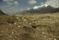
Glacier Northern Inylchek. Kazakhstan.
Tours across of Kazakhstan.
“Nature magically suits a man to his fortunes by making them the fruit of his character”
Ralph Waldo Emerson.
Glaciers of Kazakhstan.
North Inylchek glacier is located between the Tengri Tau ranges in the south and the Saryjaz ranges in the north in the Narynkol region of the Almaty region. The origins of the glacier are located on the western slope of the Meridional ridge in the ridge, which peaks are located: the Marble Wall, 6140 meters above sea level, the peak of the 100th anniversary of the Russian Geographical Society, 6276 meters above sea level, and the Plateau peak, 5850 meters above sea level.
The tongue of the glacier is located at an altitude of 3350 meters above sea level at its confluence with the South Inylchek glacier. The glacier is located on the territory of Kazakhstan for 11 kilometers. From the top of the Marble Wall to the border between the Republic of Kazakhstan and the Kyrgyz Republic, which runs from the top of Khan-Tengri peak to the north-west to the top of Semenov.
The glacier area is 17 square kilometers. The border with the Republic of Kazakhstan and the Kyrgyz Republic passing through the North Inylchek glacier is located at an altitude of 3995 meters above sea level. The rest of the glacier is located in the Ak-Suu region of the Issyk-Kul region of Kyrgyzstan.
The total length of the North Inylchek glacier is 42 kilometers, including the length of the glacier that starts from the top of the western slope of the Mramornaya Stena peak (11.2021) and the seasonal Merzbacher lake.
Six glaciers on the territory of Kazakhstan descend from the southern slopes of the Sarydzhaz ridge and connect with the right side of the North Inylchek glacier. In the main ridge of the Sarydzhaz ridge, from the junction with the Meridional, peaks stretch from east to west: Karly Tau with a height of 5550 meters above sea level, Kazakhstan 5769 meters above sea level, Bayankol 5790 meters above sea level, Eleven with a height of 5437 meters above sea level. Closing these five-thousanders is the Semyonov peak, 5816 meters above sea level, the highest in the Sarydzhaz ridge.
The most powerful glacier descends from the western slope of the Marble Wall. The wall is 5 kilometers long and stretches from north to southwest. The vertical height of the western walls reaches 1000 meters. In the eastern part of the Tengri Tau ridge, giant ice accumulations descend as a continuous ice shell to the north into the North Inylchek valley, forming a huge glacier, which is difficult to separate separately. This is the most powerful glaciation in the mountains of the Central Tien-Shan in Kazakhstan.
In the main ridge of the Tengri Tau ridge, from east to west, there are peaks: East Shater, 6,637 meters above sea level, West Shater, 6,511 meters above sea level, Saladin, 6201 meters above sea level, Khan-Tengri, 6,995.2 meters above sea level and the Petka peak at a height of 6120 meters above sea level.
Geographic coordinates of the North Inylchek glacier: N42 ° 15'03.32 "E80 ° 10'43.31"
Authority:
Alexander Petrov.
Photos by
Vladimir Serbenko.