


![]()
You are here
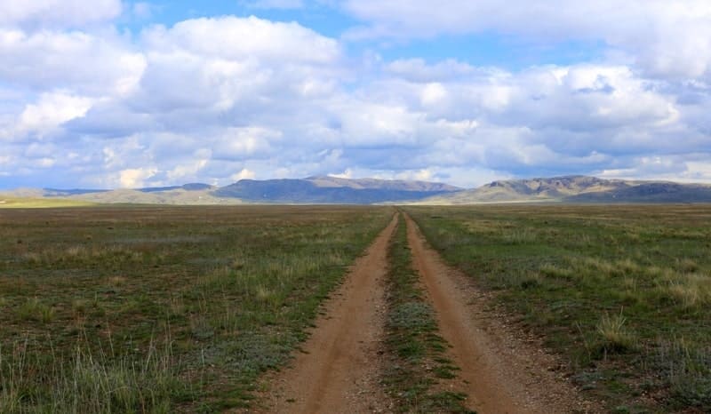
Betpak Dala desert.

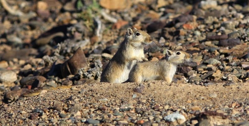
. A mammal that was discovered in the 20th century. This animal was discovered and described in 1938 by a zoologist from Zmeinogorsk, Viktor Alekseevich Selevin.")


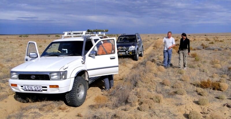
Travels in Betpak-Dala in Kazakhstan.
“Nature has no principles. She makes no distinction between good and evil”
Anatole France.
Hiking Tours Travel Central Kazakhstan.
Betpak Dala Desert is located between Chu and Sarysu rivers and near the western shore of Lake Balkhash, in south of Karaganda and north of Turkestan and Zhambyl regions of Kazakhstan.
It is situated in lower reaches of Sarysu river on the west, Chu river in the south, Balkash lake on the east, in the north it borders on Sary Arka. The total area is about 75 thousands km, the stretch from west to east is about 500km, from the north to 170km.
Betpak Dala is wavering and flat. The highest peak is Dzhambul mountain (H-974). The eastern part of Betpakdala is the continuation of Sary Aka. The climate is harsh-continental, summer is dry and hot, winter is cold. The average temperature of January is from -12 - 14’C, and + 24 + 26’C in July.
The landscapes are different, it depends on relief and content of the rock. Fauna is represented by argali and roe deer; in valley and in plains-partridge, black grouse. And there was founded zoo preserve (the area is 25 thousand hectares).
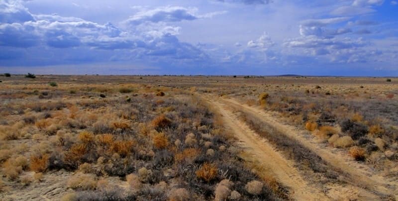
The clay saline and rocky deserts are much lifeless than the sandy, dreary landscape of this - so bare and dead, you begin to understand the attitude to the Betpak Dala of the nomadic population, well conveyed in the local toponym.
Translated from the Turkic "gave" - plain, and "Betpak" it comes from either the Turkic "batnak" - topy, or from the Persian "bedbakht" - "ill-fated", from the Kazakh epithet "unscrupulous". Kazakhs drive their herds across the Northern Golodnaya Steppe during the nomads twice a year, in spring and autumn, from the summer pastures of Sary Arka (the semi-desert of the Kazakh low mountains) to the winter pastures of the Chui Valley and the Moynkum sands and back.
They drive fast, almost without stopping due to the lack of watering places (there are almost no surface sources, but there are relatively shallow beds, at a depth of 2 to 30 meters, stratal groundwater) and scarcity of pastures: in early spring, when rains fall, they rush to live their short life ephemera (life cycle lasts a month - one and a half until moisture is enough).
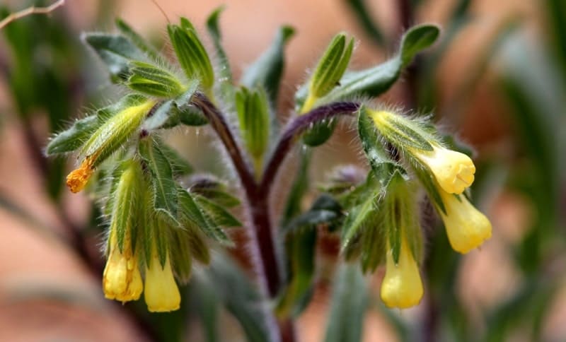
Tulips, ferules and wild onions, for a year - wormwood, teresken, biyurgun, tamarisk and saltwort, on the sand - bushes of Caragana and cereals, and even the wind is weightless everywhere brittle tumbler balls. The history of the study of the desert "Betpak Dala" by expeditions under the leadership of the zoologist V. A. Selevin is described in the book by M. D. Zverev "The End of the White Spot".
His expedition in 1936 conducted excavations in the desert of the Accasansor fossil fauna. The Betpak Dala desert is located between the lower reaches of the Chu and Sarysu rivers and the western shore of Lake Balkhash. The Betpak Dala desert is located in the south of Karaganda, in the north of the Turkestan and Zhambyl regions of Kazakhstan.
The average height of the desert is about 300 meters above sea level. The eastern part of it is a continuation of the Kazakh ridge and on large spaces is occupied by a rocky desert. The western part is a clay plain and can serve as a typical example of a clay wormwood (saltwort wormwood) desert.
Eastern part of Betpak-Dala.
Eastern part of Betpak-Dala is a continuation of the Caledonian structures of Sary Arka - a complex of dense Paleozoic sedimentary and igneous rocks. This is a socle residual plain, where low ridges alternate with numerous hollows.
In the western part, the Paleozoic rocks are submerged under a layer of horizontally occurring Mesozoic and Paleogene loose sediments (sands, sandstones, clays, pebbles), which form a reservoir plain with drainless depressions in the form of dens and closed depressions.
In general, arid denudation type of plains with the development of deflation depressions, hollows, takyrs is characteristic of Betpak Dala. The western part of Betpak-Dala is composed of Mesozoic and horizontal Palaeogene loose rocks (sands, sandstones, clay, pebbles) folded in folds, the eastern part is hilly, has a folded structure and is composed of Lower Paleozoic sedimentary metamorphic strata and granites.
The western part of Betpak Dala is a clay wormwood desert; in the salt marsh lows - biyurgun, on sand aggregations - eurotia (Eurotia), Karagan. In the east, the clay desert is combined with the rocky Salsola arbuscula on the gravelly slopes of the hills.
The eastern part of it is a continuation of the Kazakh ridge and on large spaces is occupied by a rocky desert. The western part is a clay plain and can serve as a typical example of a clay wormwood (solyanka wormwood) desert.
Western part of Betpak-Dala.
Western part of Betpak-Dala is an elevated plain, composed of horizontally-lying Mesozoic and Paleogene loose rocks. From above, mainly marine and continental Paleogene sediments (sands, sandstones, clays, pebbles) occur.
Flat areas alternate with drainless depressions in the form of logs and closed depressions with salt marshes. Sedimentary strata contain formation groundwater. On the southern edge of the desert there is fresh reservoir water, which has great pressure.
The number of rains slightly increases only in the second half of September. The desert area of Betpak Dala is about 75,000 square kilometers. The highest point is Mount Dzhambul (Zheltau) 974 meters above sea level. The length from west to east is about 500 km, from north to south, up to 170 km.
The climate and weather in the desert is extremely continental, extremely dry. Summer is dry and hot, winter is moderately cold, with little snow. Snow cover from late November to mid-February (2.5 - 3 months). The average January temperature is -13 ° C.
The average July temperature: + 25 ° С. Average annual rainfall: 100 - 150 mm (of which 30% falls in early spring, and only 15% in summer). Ephemeras in spring develop poorly, since at a time when the soil is best soaked through seasonal snow melting and early spring precipitation, it does not have time to warm up enough.
In the spring, ferrules, tulips, and bows develop, but ephemeral vegetation does not form dense cover. The vegetative cover of the desert is sparse; it is formed mainly by wormwood in spaces and elevations (black wormwood - Artemisia pauciflora f. Maikara, gray wormwood, etc.).
Biyurgun and (Eurotia ceratoides) are found in depressions; Karagany bushes grow on clusters of sand. Representatives of the fauna - argali and roe deer, in the valleys and foothill plains - saiga, gazelle, live bustard, black grouse, partridge.
A zoological reserve of 25,000 hectares has been created in Betpak Dale. Few would venture to cross the rugged ravines, the saline march and the salt marshes, covered with hills, the vast territory sandy, almost devoid of drinking water and normal roads.
Desert gray brown saline soils prevail here. After rains on clay soils impassable mud forms and pools of takyrs bloom. Until very recently, nobody lived in this desert, and until the 1930s. no one seriously studied it.
And when they began to study, they discovered a lot of minerals and amazing animals: the same age as mammoth saiga, the carnivorous “mouse” - Sonsola arbuscula sonya (named after the first explorer of the desert Betpak-Dala Viktor Selevin, who discovered 11 new species in total).
Among other things, a rich uranium deposit was discovered, and at present this strategic raw material is extracted by a well method in the area of the village of Kyzemshek (in Soviet times - Stepnoye); The development of neighboring fields is also planned.
Now it is the task of the government of Kazakhstan, and from the mid-1950s to the early 1990s, the desert areas were populated mainly by the Soviet cosmonautics (and now Russia rents the Baikonur cosmodrome until 2050 under the current agreement) and the Ministry of Defense (Kapustin Yar, Semipalatinsk, etc.).
In particular, the Sary Shagan test site operates on the territory of Betpak-Dala: this mega missile defense project began to be implemented in the late 1950s, and to this day this part of the desert remains a white spot on the map. Betpak Dala is one of the world's largest clay deserts.
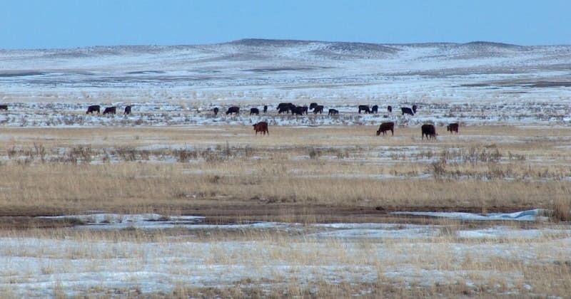
The territory of Betpak-Dala is used as spring and autumn pastures. Cattle are driven through it from the summer pastures of the semi-desert of the Kazakh Hills (Sary Arka “steppe”) to the winter pastures of the Chui valley and the Moynkum sands and back.
Opportunities to increase the herd population of herds is limited due to lack of watering. The terrestrial water sources of the desert is poor. However, there is abundant groundwater located at a relatively shallow depth. Fresh water can be used by creating artesian wells.
The provision of watering places is also possible by taking simple measures to reduce the evaporation of spring waters accumulating in depressions on clay soils - takyrs; recommended planting on the shores of takyr water bodies of trees and shrubs, the creation of simple hydraulic structures.
First explorations of Betpak Dala desert.
May 1796 to June 1797. The first mentions of Betpak Dala were preserved in the "Journal of the campaign of second lieutenant and ataman D. Telyatnikov to Tashkent with a description of the route, location, and other things described by sergeant A. Beznosikov" (May 1796 - June 1797).
1800. M. S. Pospelov and T. S. Burnashev, an official and mining officer of the department of the Kolyvano-Voskresensk mining plants, headed the embassy to Tashkent. Their route lay from the Yamyshev fortress to the Nura River and then through Betpak Dala to the Tashkent possessions.
1813 - 1814. Filipp Nazarov's trip to Central Asia. His route ran from Omsk through Petropavlovsk and then through Betpak Dala to Tashkent and Kokand.
1840 - 1843. Expedition of A. I. Shrenk to survey and study the territory of Central Kazakhstan and Betpak Dala. The expedition routes passed through the steppes of the Ishim Valley, the Ulutau Mountains, the valleys of the Chu and Sarysu Rivers. A. I. Shrenk was one of the first to cross the Betpak Dala desert twice.
1841. Policeman Lobanov prepared a "Description of the southwestern part of the Hungry Steppe".
September 1883. V. N. Gern, Akmola district chief, made a trip to the western part of the Betpak Dala desert.
1894. Military surveyor, topographer Yuliy Aleksandrovich Schmidt conducts geodetic research in Betpak Dala. In 1895, he was awarded the N.M. Przhevalsky Silver Medal for geodetic work in Central Asia.
1931, the expedition to Betpak Dala was organized and conducted by the Central Museum of Kazakhstan (headed by director A.S. Makhonin).
1933-1935, the expedition to Betapak Dala was conducted by the Central Asian State University under the leadership of V.A. Selevin.
Curious facts of Betpak-Dala desert:
1. In 2003, the image of the rodent "Seliviniy Betpak Dalinzis" was applied to the postage stamp of the Republic of Kazakhstan.
2. At the Uvanas deposit (Kyzemshek village), uranium is extracted using the method of underground borehole leaching from uranium water (unsuitable for other uses). After uranium is extracted, water is pumped back into the well.
3. Poachers kill primarily saiga males in pursuit of their horns, especially valued in Chinese medicine. This leads to a sharp reduction in livestock numbers.
4. Takyry - areas where water accumulates after the rains. After the rains, takyrs immediately bloom because of the mass of bacteria and microscopic algae in the soil, which, after evaporation of moisture, surround themselves with hardening mucus and sink into dormant state until the next rain; Because of this dried mucus, takyrs become as hard as stone.
5. The Betpak-dala saiga population was one of the largest. This is partly due to the binding of animals to flat terrain with dense soils: the feature of saiga running at a speed of up to 80 km / h is that on rough terrain animals become completely helpless, they cannot jump even simple obstacles on the run.
In addition to the flat terrain, the desert provides another advantage: the ability to escape from wolves away from watering (females breed their offspring in a safe, dry zone).
Geographical coordinates of Betpak Dala desert: N45°59'13 E70°52'11
Authority:
N. A. Gvozdetsky, N. I. Mikhailov. “Physical Geography of the USSR. Asian part. Third edition, revised and supplemented. Moscow "Thought" 1978. http://tapemark.narod.ru/geograf/1_5_5.html
http://geosfera.org/aziya/kazaxstan/1573-betpak-dala.html
Photos by:
Alexander Petrov.