


![]()
You are here
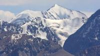
Bezsonov glacier.
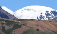
Glaciers in Kora Gorge in Dzungarsky Alatau.
“Mountains, mountains! What magnetism is hidden in you! What a symbol of tranquility lies in each sparkling peak! The most daring legends are born near the mountains. The most human words come from the snowy heights. Some people are afraid of the mountains and claim that the mountains choke them. Aren't these people afraid of big things?
Nicholas Roerich.
Trip to Kora gorge in Dzungarsky Alatau.
Bezsonov glacier is located on the southern slope, in the upper reaches of the Kora gorge in the Dzungarian Alatau ridge, in the Eskeldinsky district of the Almaty region. The Bezsonov Glacier, 4.9 kilometers long, 10.7 square kilometers in area, with a perimeter of 20.05 kilometers.
The upper limit of the glacier is located at an altitude of 3919.7 meters above sea level. The tongue of the glacier is located at an altitude of 2981 meters above sea level, belongs to the basin of the Kora River. Thus, from 1909 to 1972, the end of the Bezsonov glacier receded by 880 meters, and its area decreased by 0.5 square kilometers.
The highest speeds of ice movement were measured on the Bezsonov glacier. At 2 - 3.5 kilometers from its end, the average speed of ice movement was 16.7 m/year. The Sapozhnikov glacier, 3.3 kilometers long, is located 2.6 kilometers northeast of the Bezsonov glacier.
At 5.7 kilometers northeast of the Bezsonov glacier, there is a small Altynsarin glacier with a length of 1.2 kilometers. 4.2 kilometers west of the Bezsonov glacier is the Tronov glacier, 5.4 kilometers long. There are 1369 glaciers with a total area of 1000 square kilometers in the mountains of the Dzungarian Alatau.
About 42 kilometers of cubic water are conserved in glaciers. Glaciers occupy an altitudinal belt from 3000 meters above sea level to the crest of the ridge 4000 - 4360 meters above sea level. Moraines cover from 4 - 5% to 10 - 20% of the surface of glaciers.
The firn line on the glaciers runs at an altitude of 3480 to 3840 meters above sea level, depending on the exposure and morphological type of glaciers. On the southern slopes the firn line is 100 - 120 meters higher than on the northern ones, on valley glaciers it is 70 - 80 meters lower than on the cirque ones.
The main source of nutrition for the glaciers of the Dzungarian Alatau is atmospheric precipitation, most of which falls in the accumulation area in solid form. The average amount of precipitation at the height of the supply line is about 900 mm per year, varying in different years from 770 to 1270 mm.
The feeding boundary divides the glaciers of the Dzungarian Alatau into two parts approximately equal in area - the feeding area and the flow area. The glacial coefficient of valley and basin glaciers averages 1.12, cirque glaciers - 0.89, hanging glaciers - 1.0.
The predominant type of ice formation on the glaciers of the Dzungarian Alatau is firn and ice. The firn and ice zone covers most of the accumulation area above 3500 meters above sea level. Below is a zone of ice feeding, which occupies approximately 20% of the area of glaciers.
The process of ice formation in the first of the zones is completed within a few years, in the second - within one year. The daily rates of ice movement during the ablation period exceed the average annual rates by 1.2 - 1.4 times.
The main factor in the melting of glaciers in the Dzungarian Alatau is solar radiation. With a cloudiness of 4 points, its share reaches 74%, with a cloudiness of 6 - 7 points - 57% of the heat balance. The average daily ice melting at the ends of glacial tongues, depending on the weather, is from 2.2 to 4.6 cm, and in the middle parts of the glaciers - from 1.4 to 3.3 cm (in the water layer).
Glaciers lose more ice due to melting than they receive from the firn region due to movement. The mass balance of the glaciers on which observations were made is negative. The balance of the glaciers of the Dzungarian Alatau has been predominantly negative over the past few decades, as evidenced by the retreat of the ends of many glaciers and reduction in their area.
Geographical coordinates of Bezsonov Glacier: N44°53'05.13" E79°25'40.30"
Authority and photos by
Alexander Petrov.