


![]()
You are here
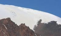
Kazan Glacier. Dzungarian Alatau.
Kazakhstan private tour in Dzungarsky Alatau mountains.
“There, at a height, closer to God, a person becomes purer and nobler”
Vladislav Terzyul.
Glaciers in gorges of in Dzungarsky Alatau mountains.
Kazan glacier is located in the upper reaches of the Kazan River, on the northern slope, the southern part of the Dzhungarsky Alatau ridge in the Eskeldinsky district of the Almaty region. In the upper reaches of the Kazan River is a glacier of the same name.
Kazan Glacier is divided into two branches: East and West. The upper limit of the Eastern branch of the glacier is located at an altitude of 3951 to 4082 meters above sea level. The tongue of the glacier is located at an altitude of 3382 meters above sea level, the river of the same name flows from its northern part.
The area of the Eastern branch of the Kazan glacier is 2353943 square meters, the perimeter is 7013 meters. The length of the glacier is 3.6 kilometers. The upper limit of the Western branch of the Kazan glacier is located at an altitude of 3969 meters above sea level.
The tongue of the Western Kazan glacier is located at an altitude of 3319 meters above sea level, one of the upper tributaries of the Kazan River flows from its northwestern part. The area of the Western branch of the Kazan glacier is 2520631 square meters, the perimeter is 6095 meters.
The length of the glacier is 1.9 kilometers. The area of the closed part of the Western Kazan glacier is 1004303 square meters. There are 1369 glaciers with a total area of 1000 square kilometers in the mountains of the Dzungarian Alatau.
About 42 kilometers of cubic water are conserved in glaciers. Glaciers occupy an altitudinal belt from 3000 meters above sea level to the crest of the ridge 4000 - 4360 meters above sea level. Moraines cover from 4 - 5% to 10 - 20% of the surface of glaciers.
The firn line on the glaciers runs at an altitude of 3480 to 3840 meters above sea level, depending on the exposure and morphological type of glaciers. On the southern slopes the firn line is 100 - 120 meters higher than on the northern ones, on valley glaciers it is 70 - 80 meters lower than on the cirque ones.
The main source of nutrition for the glaciers of the Dzungarian Alatau is atmospheric precipitation, most of which falls in the accumulation area in solid form. The average amount of precipitation at the height of the supply line is about 900 mm per year, varying in different years from 770 to 1270 mm.
The feeding boundary divides the glaciers of the Dzungarian Alatau into two parts approximately equal in area - the feeding area and the flow area. The glacial coefficient of valley and basin glaciers averages 1.12, cirque glaciers - 0.89, hanging glaciers - 1.0.
The predominant type of ice formation on the glaciers of the Dzungarian Alatau is firn and ice. The firn and ice zone covers most of the accumulation area above 3500 meters above sea level. Below is a zone of ice feeding, which occupies approximately 20% of the area of glaciers.
The process of ice formation in the first of the zones is completed within a few years, in the second - within one year. The daily rates of ice movement during the ablation period exceed the average annual rates by 1.2 - 1.4 times.
The main factor in the melting of glaciers in the Dzungarian Alatau is solar radiation. With a cloudiness of 4 points, its share reaches 74%, with a cloudiness of 6 - 7 points - 57% of the heat balance. The average daily ice melting at the ends of glacial tongues, depending on the weather, is from 2.2 to 4.6 cm, and in the middle parts of the glaciers - from 1.4 to 3.3 cm (in the water layer).
Glaciers lose more ice due to melting than they receive from the firn region due to movement. The mass balance of the glaciers on which observations were made is negative. The balance of the glaciers of the Dzungarian Alatau has been predominantly negative over the past few decades, as evidenced by the retreat of the ends of many glaciers and reduction in their area.
Geographical coordinates of Kazan Eastern glacier: N44°48'13.16" E79°58'50.72"
Geographical coordinates of Kazan Western glacier: N44°48'16.35" E79°57'24.82"
Authority and photos by
Alexander Petrov.