


![]()
You are here
Caspian lowland in Kazakhstan.
Tours on Caspian lowland.
“The true purpose of your journey is not a place on the map, but a new outlook on life”
Henry Miller
Sights of Caspian lowland.
Caspian lowland is located in the southeast of the East European Plain on the northern coast of the Caspian Sea. The lowland is bordered in the north by the Obchiy Syrt, in the west by the Volga Upland and the Ergeni, in the east by the Cis-Ural Plateau and Ustyurt. It is located on the territory of the Astrakhan region in Russia, West Kazakhstan, Atyrau regions in Kazakhstan.
The lowland stretches for 500 kilometers from north to south, for 700 kilometers from west to east, the area of the Caspian lowland is about 200,000 square kilometers. The height above sea level of the Caspian lowland fluctuates: the highest point of the northern regions is 149 meters above sea level, and the southern regions are located 28 meters below sea level.
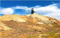
Among it, separate hills rise - the Inder Mountains, the Big and Small Bogdo and others. In the northwest of the lowland is a site called the Black Lands. It is a semi-desert area, which even in winter is not covered with snow due to strong winds.
These lands got their name due to dark brown soils and black wormwood. The Caspian lowland includes several large tectonic structures (Caspian syneclise, Ergeni uplift, Nogai and Terek depressions). In the Quaternary, it was repeatedly flooded with the waters of the Caspian Sea, which left clayey and loamy deposits in the northern part, and sandy deposits in the southern part.
The relief of the Caspian lowland is monotonous. Since it has repeatedly been the bottom of the sea, several elevated sections are not found over tens of kilometers. There are most of all flat clay plains and sandy massifs. The Caspian lowland includes Ryn-sands, Batpaysagyr, Bozanay, Kosdaulet, Myntobe, Taisoigan, Karakum.
By the size of the territory, the Ryn-sands, located to the west of the Ural River, are the largest. Their surface is slightly wavy - sandy mounds alternate with shallow depressions. Barkhan sands are also found among the sandy massifs fixed by plants.
On flat clay plains there are small and shallow basins occupied by lakes and salt marshes. On the Caspian lowland, the uplands are dome-shaped. Some of them reach 100 meters in height and look like mountains among the flat plain.
At the base of these hills, at a depth of 100 - 200 meters, layers of rock salt lie, which have formed salt domes. They are associated with deposits of oil, gas, gypsum, potassium and other minerals. In the southern part of the lowland there are "Baer hillocks", the height of which reaches 10 - 15 meters, and the length is up to 20 kilometers.
According to Academician K. M. Baer, who discovered this type of relief, the mounds were formed as a result of partly deflation (i.e., the destructive activity of the wind and blowing sandy material) and partly - eolian accumulation (i.e., blown sand is not carried away over long distances , but accumulates nearby).
The climate is dry, continental. The average temperatures in January are from -14°С in the north to -8°С on the coast, in July - respectively +22°С and +23°С. Precipitation - from 200 to 150 mm in the southeast, up to 350 mm in the northwest, evaporation is about 1000 mm.
Dry winds are frequent. The Caspian lowland is crossed by the Ural, Volga, Terek, Kuma rivers, small rivers (Big and Small Uzen, Wil, Sagiz) dry up in the summer or break up into a series of basins, forming lacustrine overflows - Kamysh-Samarsky lakes, Sarpinsky lakes.
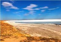
There are many salt lakes (Inder, Baskunchak, Elton and others). The soil vegetation of the Caspian lowland is characterized by great complexity. The soils are light chestnut, solonetsous, there are solonetzes, saline land.
In the north - sagebrush-cereal vegetation, in the south the amount of grasses decreases, sagebrush prevails. Used as pasture. In the Volga-Akhtuba floodplain - vegetable growing, melon growing, gardening. Oil fields (Emba oil region, table salt in the lakes (Baskunchak, Elton, etc.).
Geographic coordinates of Caspian lowland: N47°48'47.50" E50°51'21.71"
Authority:
http://www.caspianmonitoring.ru/
Photos by
Alexander Petrov.