







You are here
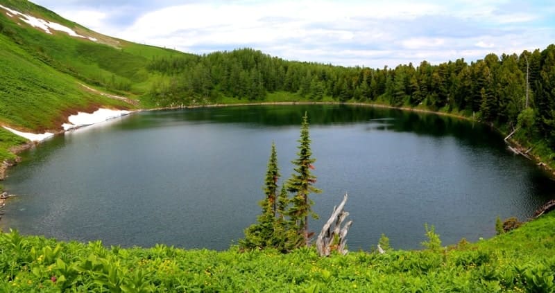
Cherbakov Lake in West Altai Reserve.

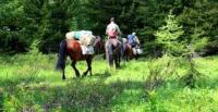
Wildlife Tours in West Altai Reserve.
“Altai mountains are located in the north-east of Kazakhstan. Kazakhstan includes southern and northern parts of Altai between 48 and 51 degrees north latitude, 82 and 88 degrees east longitude. Kazakhstan Altai occupies almost a tenth of the territory of the republic”
Encyclopedia of Kazakhstan. Volume 4, 1991.
Flower Tours in West Altai Reserve.
Lake Shcherbakov is a deep tarn lake in the Western Altai.
Hidden among the harsh high-mountain landscapes of the eastern Ivanovo Range lies one of the most interesting lakes in the West Altai State Nature Reserve – Lake Shcherbakov. This relatively small but unusually deep body of water attracts attention not only with its clear turquoise water, but also with its unique origins, unique hydrological regime, and surprisingly harmonious combination of rocky slopes, coniferous taiga, and alpine meadows.
For a long time, the lake was known as Listvyazhnoe, but at the beginning of the 21st century, it received a new name in honor of the outstanding Kazakhstani naturalist Boris Shcherbakov, who pioneered the creation of the West Altai State Nature Reserve.
Today, this lake is rightfully considered one of the most fascinating natural attractions in the Ivanovo Range.
Geographical location of Lake Shcherbakov.
Lake Shcherbakov is located at an altitude of 1865 m. a. s. l. within the Ridder city administration of the East Kazakhstan Region. It is located in the eastern spurs of the Ivanovskiy Range, west of the Koksinckiy Range, in the central part of the West Altai State Nature Reserve.
A complex of high-mountain reservoirs is located in the immediate vicinity of the lake. Kedrovoe Lake is 1.1 kilometers to the southeast, First Beloubinskoye Lake is approximately 1.6 kilometers to the south, and Fourth Beloubinskoye Lake is 2.3 kilometers to the southeast.
This location makes Lake Shcherbakov an important element in the unified system of glacial lakes in the eastern part of the Ivanovskiy Range.
Origin of Lake Shcherbakov.
The lake is of moraine-dammed origin, which determined both its shape and its current hydrological regime. During the last stage of mountain glaciation, a glacier descending the northern slope of the Ivanovsky Range gradually carved out a deep glacial basin.
At the same time, huge masses of debris - boulders, rocks, rubble, sand, and loam - accumulated in front of the glacier. After the glacier melted, these moraine deposits formed a natural dam, blocking the meltwater. This created a deep lake basin, which gradually filled with water, primarily from snowfields and precipitation.
Today, the surrounding terrain retains numerous signs of ancient glaciation - the steep sides of the glacial cirque, rock falls, moraine ridges, and a powerful dam composed of coarse debris. Morphometric Features The lake extends from southeast to northwest.
Its length reaches 316 meters, its maximum width is 184 meters, its water surface area is 48,532 square meters, and its shoreline is 839 meters long. Despite its relatively small size, the lake is distinguished by its considerable depth. Its maximum depth reaches 42 meters, making it one of the deepest high-mountain bodies of water in the region.
Its water volume is approximately 724,600 cubic meters, indicating the significant capacity of the glacial basin. A particularly interesting feature is the absence of surface runoff. The lake is endorheic. It is fed by the seasonal melting of snowfields located in the northwestern part of the glacial cirque, as well as by precipitation.
Water discharge occurs primarily through evaporation and, probably, underground filtration through the moraine deposits. Although the specific filtration pathways have not yet been determined, they most likely ensure the lake's stable water balance.
Relief and Surrounding Landscape of Lake Shcherbakov.
The lake occupies a deep intermontane depression surrounded by steep slopes. The southern slope begins directly from the main ridge of the eastern Ivanovsky Range. It is characterized by a significant steepness, in places turning into rocky outcrops and scree.
The shores are difficult to access from almost all sides. The moraine dam is 120 to 180 meters wide and is composed of large boulders, rubble, and other debris from an ancient glacier. It is this natural dam that holds back the enormous mass of water.
The lake's color is particularly striking. In clear weather, the water takes on a rich turquoise hue. This color is due to the exceptional transparency of the water, the way it reflects sunlight, and the presence of tiny mineral particles of glacial origin.
Unlike many other mountain lakes, the surface of Shcherbakov often resembles a huge mirror, reflecting the surrounding peaks, cedar forests, and the rapidly changing high-altitude sky.
Climate of Lake Shcherbakov.
The climate of the region is typically high-altitude. Even in summer, the air temperature can change dramatically within a few hours. Warm, sunny days are often followed by cold fogs, prolonged rains, or strong winds. The large amount of precipitation contributes to the long-term preservation of snowfields, which feed the lake with cold meltwater.
Due to its great depth, the water warms up much more slowly than in neighboring Kedrovoe Lake, so even in summer it remains very cold.
Flora of Lake Shcherbakova.
The shores of the lake are surrounded by typical natural communities of the Western Altai. Siberian cedar, larch, dwarf birch, and a variety of shrubs grow here. Tall grass thickets develop in wetter areas, and subalpine meadows are found on the open slopes.
The contrast between the dark green of the coniferous forest and the turquoise surface of the water is particularly striking. The vertical zonation of the vegetation is clearly visible even in a relatively small area: from the cedar taiga to the treeless rocky slopes.
Fauna of Lake Shcherbakov.
The lake's surroundings are home to many animals of the Western Altai. The coniferous forests are home to maral, roe deer, brown bear, sable, squirrel, chipmunk, and numerous bird species. The nutcracker plays a special role, dispersing Siberian cedar seeds and promoting natural forest regeneration.
The high degree of preservation of the natural complexes is explained by the strict protection regime of the reserve's territory.
History of Lake Shcherbakov's Name.
Until the early 21st century, the lake was known as Listvyaznoye Lake. In 2002, while preparing maps of specially protected natural areas, the Institute of Geography of the Academy of Sciences of the Republic of Kazakhstan named the lake after Boris Shcherbakov, a renowned naturalist who made a significant contribution to the study of the nature of Eastern Kazakhstan and actively supported the creation of the West Altai State Nature Reserve.
The new name became a unique tribute to a man who dedicated many years to preserving the natural heritage of Altai.
Legend of Lake Shcherbakov.
Old guides told a beautiful tale. They say that when the glaciers finally left the Ivanovsky Ridge, they left behind the deepest lake as a mirror of memory. The spirits of the mountains wanted to preserve in it the reflection of the sky as it was thousands of years ago.
Therefore, the lake has no visible outflow. Anything that falls into its waters remains here only for a moment, then disappears without a trace through invisible underground passages back into the heart of the mountains. If you gaze at the lake's calm surface for a long time on a windless day, you'll notice how the reflection of the clouds seems deeper than the water itself.
Old hunters said that at such moments, the lake reveals not the real Altai, but ancient Altai as it was during the time of the great glaciers. Of course, this is just a beautiful legend, but it resonates surprisingly with the lake's harsh and mysterious appearance.
History of Lake Shcherbakov Exploration.
The history of scientific study of the lake remains only partially understood. Information about the first explorers is still lacking. However, it is known that the Ivanovsky Ridge region has been repeatedly visited by geologists, botanists, hydrologists, and staff of the West Altai State Nature Reserve.
Boris Shcherbakov, after whom the lake is now named, played a particularly important role in the study of the region's natural environment.
A hike to Shcherbakova Lake from Kedrovoe Lake in June 2019.
In July 2019, the author and friends took a radial hike from Kedrovoe Lake to Shcherbakov Lake. The route runs along the northern slope of the Ivanovsky Ridge through picturesque pine taiga. As you ascend, the forest gradually gives way to rocky scree and sparse patches of subalpine vegetation.
The only direct access to the water is in the western part of the lake, where a small stream flows into it. The remaining banks are steep and, in places, almost vertical. It is here that the solitude of this corner of Altai is especially acute. Even a light breeze quickly dies down among the surrounding slopes, and the silence is broken only by the babbling of the stream and the sounds of birds.
Tourist information about Shcherbakova Lake.
Lake Shcherbakova is one of the most interesting sites in the West Altai State Nature Reserve. The most convenient route is considered to be from Kedrovoe Lake, which runs along the northern slope of the Ivanovsky Ridge. Despite the short distance, the route requires good physical fitness, as it passes through rugged mountain terrain.
Visiting is permitted only with a special permit from the West Altai Nature Reserve and in compliance with the reserve's regulations. The best time to visit is mid-June to August, when snowfields no longer impede travel and the taiga and alpine meadows are at their peak.
Significance of Lake Shcherbakov.
Lake Shcherbakova is of great interest as a monument to the ancient glaciation of the Western Altai and an important element of the high-mountain natural complexes of the Ivanovsky Range. It clearly demonstrates the formation processes of moraine-dammed lakes, the characteristics of the water regime of endorheic mountain reservoirs, and the influence of glacial legacy on the modern topography. Its conservation value is equally important.
The lake is located within a specially protected area that preserves the natural ecosystems of cedar taiga, subalpine meadows, and high-mountain rocky slopes. For travelers, this place offers a rare opportunity to see the nature of Western Altai almost as it was many centuries ago.
Geographic coordinates of Lake Shcherbakova are: N50°18'08 E84°08'05




Authority and photos by:
Alexander Petrov.