


![]()
You are here
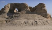
Chirik fortress 3.
History of architecture and construction of Kazakhstan.
"The best that history gives us is the enthusiasm it generates."
Johann Wolfgang Goethe.
The image of cities, historical monuments of Kazakhstan.
The Chirik 3 fortress is located on a natural hill 1 kilometer west of Chirik-rabat on the left bank of the Zhanadarya in the Zhalagash district of the Kyzylorda region. The monument was opened in 1957 by KhAEE, while traces of internal development were revealed.
In the plan the fortress is rectangular (108 x 122 meters) with rounded corners. The walls, the width of which in the lower part was a little more than 3 meters, survived to a height of up to 1.5 meters. Arrow-shaped loopholes up to 1.3 meters high were made in the walls, located in one row at a height of 1.2 meters from the base of the fortress walls, at a distance of 1.5 meters from each other.
Similar arrow-shaped loopholes and construction techniques are quite common in the monuments of ancient times of Central Asian agricultural oases [Khozhaniyazov, 1981, p. 43 56]. The fortress was attributed by researchers to the Chirikrabat culture [Vainberg, Levina, 1993, p. 22 - 23].
Chirikrabat archaeological expedition [Tezhekeyev, 2007b, p. 226]. In 2014, the Chirikrabat archaeological expedition began stationary archaeological excavations and carried out a topographic survey. [Kurmankulov, Utubaev, Tezhekeyev, Darmenov, Iskakov, 2014, p. 165 - 170].
Geographic coordinates of the fortress Chirik 3: N44 ° 05'11.86 "E62 ° 54'04.87"
Authority:
https://history.institute/drevnego-vostoka-istoriya/ukreplennyie-usadbyi-balandyi-inkar-kala-97577.html
Utubaev Zhanbolat Raimkulovich. “Settled agricultural culture of the Eastern Priaralye (Second half of the 1st millennium BC). Dissertation for the degree of candidate of historical sciences. Kemerovo - 2018.2018