


![]()
You are here
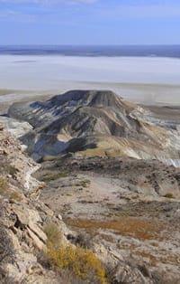
Cliff Kaplankyr in Turkmenistan.
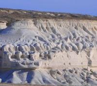
Cliffs of Ustyurt plateau in Turkmenistan.
“Ask nature, she keeps all the truths and will answer your questions without fail and satisfactorily”
R. Bacon.
Best routes in Turkmenistan.
Kaplankyr ridge or cliff is located 92 kilometers east and slightly north of the eastern coast of the Kara-Bogaz-Gol Bay, 59 kilometers northeast of the Chagyl village, 38 kilometers northwest of the Kaplankyr reserve in the Turkmenbashi etrap, in the Balkan velayat in the north-west of Turkmenistan.
The length of the Kaplankyr cliff is 121 kilometers. Cliff stretches from the southeast to the northwest to the west and again turns to the northwest. The most dominant mark of the cliff, 221 meters above sea level, is located between the Kazakhlyshor saline land and the Depmechai valley and slightly north of the Seldepme valley.
The second mark of the cliff, 219 meters above sea level, is located 7.5 kilometers southwest of the previous mark. The third dominant height of 218 meters above sea level is located 15.3 kilometers to the west and slightly north of the mark of 221 meters.
On the southern and southeastern side of the Kaplankyr cliff, there is the Kazakhlyshor saline land. Almost to its central part, the state border between the Republic of Kazakhstan and Turkmenistan runs along the cliff.
The northeastern part of the cliff with a length of 13 kilometers is located on the territory of the Republic of Uzbekistan. The northern part of the cliff with a length of 20 kilometers is located on the territory of the Republic of Kazakhstan.
To the south, in the central part of the cliff, for 31 kilometers and to the south of the Kazakhlyshor saline land, the Kumsebshen sands are located. The meridional part of the Eastern Cliff of the Ustyurt Plateau is located 111 kilometers northeast of the Kaplankyr Ridge.
In the south-west, the cliff is surrounded by the Begendazhal ridge with a dominant elevation of 332 meters above sea level. To the east of the ridge are the Babashi Mountains with the highest elevation of 3598 meters above sea level.
The Kaplankyr monoclinal ridge, which merges with Ustyurt, is located in the northeast of the low-mountain Tuarkyr system. In the cliff and at the foot of Kaplankyr, Cretaceous and Paleogene rocks come to the surface, and the plateau inclined to the east is formed by the same Neogene cover as on Ustyurt.
In the Kaplankyr region, in contrast to Mangyshlak, desert landscapes completely dominate, and in its main part (with the exception of the northwestern edge), this region is already in the southern desert zone. Clayey wormwood-saltwort desert with carbonate gray-brown soils (according to E.V. Lobova) dominates on the ridges of the frame of the Kaplankyr system, turning into a solonchak desert with gray-brown saline land soils.
Southern wormwood prevails here, there are also boylych (Salsola arbuscula) and other species of Salsola, biyurgun, rheomyria, nanophyton. On ridges, plateaus, and especially on steep slopes with rocky cliffs at the top, the clay and saline desert often turns into rocky.
South of Kaplankyr stretches a strip of sandy Uchtagankum desert with white saxaul and other psammophytes, which is one of the northwestern "bays" of the Karakum beyond Uzboy. To the east, at the foot of the Kaplankyra ledge, there is an extensive depression confined to the axis of the anticline with an outcrop of Cretaceous rocks - the Goklenkui saline land, a typical saline halophytic desert.
Geographical coordinates of Kaplankyr chink: N41°21'39.23" E55°58'42.94"
Authority:
A.G. Isachenko, A.A. Shlyarnikov. The nature of the world. "Landscapes", Moscow, "Thought", 1989. (Andrusov, 1915; Borneman and Spiridonov, 1929; Dolenko, 1930; Rusanov, 1930; Fedorovich, 1947; Rybin, 1952; Shlesinger and Pleshcheev. 1959; Kazakhstan, 1969; Faizov, 1970; Geology of the USSR, 1970; Soils of the Mangyshlak Peninsula, 1974; Borovsky and Dzhamalbekov, 1983; Safronova, 1986).
Photos by
Alexander Petrov.