


![]()
You are here
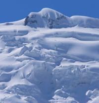
Didal Glacier.
Glaciers on northern slope of Peter Great ridge.
“I was informed that seven years ago there was a terrible snowfall here, which buried four shepherds, several dogs and about 100 sheep.”
V.I Lipsky. "Mountain Bukhara". 1896 – 1899.
Trip along Surkhob River in Rasht region.
Didal glacier is located at an altitude: upper limit is 4762.2 meters above sea level (peak Kavdal. Kaudal), end of the glacier is 2623 meters above sea level, located on northern slope of Peter the Great ridge, in upper reaches of Dara River, in Tajikabad region Republic of Tajikistan.
On the northern slope of the Peter the Great ridge in the Surkhob basin there are about fifty small glaciers. The largest among them is Didal: 4.8 kilometers long, with an area of 1.6 square kilometers. The glacier is a complex valley, with a small tributary on the right side.
The Dara River, 11.6 kilometers long, flows out of the glacier, which is a left tributary of the Surkhob River in the vicinity of the village of Karasagyr. The mouth of the river is located at an altitude of 1480 meters above sea level. The tongue of the glacier hangs over a steep and narrow rocky gorge.
Usually Didal moved at a speed of several centimeters per day, but unexpectedly in the summer of 1974 his speed increased tens of times, and the surface was split by deep cracks. At the source the glacier sank, and towards the end it rose up like a wave.
The extent of the Didal glacier increased literally before our eyes. At times, short-term but violent mudflows broke out from under the glacier and rushed down the Dara River. By the beginning of August, the glacier had increased by 600 meters. Its movement was accompanied by the rustling, crackling and thunder of collapsing ice blocks and jams.
On the evening of August 12, the speed of the glacier increased, now it was moving forward by one and a half to two meters per hour. More and more mudflows erupted from under the glacier, and the roar of movement became more powerful.
The front part of the glacier was a 20-meter ice cliff, through which in places streams of water broke through. By noon on August 13, the glacier had increased by 40 meters, and its movement speed had reached five meters per hour. At noon, a particularly powerful mudflow erupted from the bottom of the glacier, followed by a sound similar to distant thunder.
The front part, about 600 meters long, broke away from the glacier - about 1.5 million cubic meters of ice. Boiling in high waves of crushed dirty blue ice, a gigantic stream rushed down. It consisted of three shafts: the first low, mixed with water; the second is much denser and higher, up to sixty meters high and, finally, the third, made of almost dry ice.
As it moved, the ice stream tore off the turf from the slopes. The valley of the Dara River for almost two kilometers was covered with a layer of broken ice. However, the river quickly made its way through the ice blockage, there was no accumulation of water, the flow stabilized, and the shortened Didal glacier continued to advance, passing 20 - 30 meters per day, gradually filling the empty glacier bed.
By mid-September it had reached the length at which a collapse occurred, but this time no extraordinary phenomena occurred. Apparently, the ice approaching from above turned out to be stronger than the previous one; in addition, it became colder, the melting of the ice decreased, and the river became shallow.
Even the next year, when the glacier calmed down and began to move at normal speed, traces of its movement were visible. The surface of the Didal glacier dropped by 20 - 50 meters, steep ice steps and cliffs up to 60 meters high formed in its upper reaches, and the width of the glacier decreased. And the ice block on the Dara River melted within 2 years.
Historical information about Didal glacier.
When processing observational materials, it turned out that the famous researcher of Central Asia V.I. first mentioned the Didal glacier in his book “Mountain Bukhara”. Lipsky. His book contains a photograph of this glacier, apparently after another movement: traces of subsidence are visible on the sides and numerous cracks.
Lipsky wrote:
“I was informed that seven years ago there was a terrible snowfall here, which buried four shepherds, several dogs and about 100 sheep.”
Obviously, it was not a collapse of snow, but of ice. Therefore, we can name another date for the movement and collapse of the glacier - 1890. Local old-timers recall that the glacier moved in 1926. This means that 36-48 years pass between movements at the Didal glacier until a certain, critical mass of ice accumulates. In addition, as already mentioned above, intraglacial meltwater plays a major role in the movement of the Didal glacier, loosening the ice and washing away the glacier from below.
Geographic coordinates of Didal glacier: N38°58'57 E70°42'13
Photos by:
Alexander Petrov.