


![]()
You are here
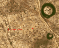
Geoglyph "Zaktama".
Mystical secrets of Kazakhstan.
“Do not let the scoundrel into the secrets - hide them,
And keep secrets from the fool - hide them,
Look at yourself among the people passing by,
Keep silent about hopes to the end - hide them!"
Omar Khayyam.
Unexplored landscapes of Kazakhstan.
Geoglyph "Zaktama" in the form of 9 barrows is located at an altitude of 179 meters above sea level, located 140 meters west of the Zaktama necropolis, 2.7 kilometers east of the right bank of the Kabyrga River (Ulkayak River basin), 28.4 kilometers southwest of the village of Shili, 80 kilometers northwest of the village of Torgai, 52.7 kilometers southwest of the village of Bidayik, in the Aytekebiysky district in the southeast of the Aktobe region.
Geoglyph "Zaktama" is oriented from southeast to northwest. The line of burial mounds consists of 9 small mounds, each 10 to 11 meters in diameter. A barrow is located 140 meters to the east of the mounds, its outer diameter is 65 meters, and its inner diameter is 40 meters.
Archaeological excavations were carried out on the mound. At 780 meters to the north, next to the road, there is another mound. 500 meters to the north and northeast there are 4 more scattered mounds.
Geographic coordinates of «Zaktama» geoglyph: N50°12'30.28" E62°42'58.82"
Authority and photos by
Alexander Petrov.