


![]()
You are here
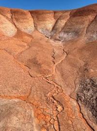
Mountains ridge of Shalkarnur.
Trip to Shalkarnur mountains and Shalkarteniz depression.
“From communication with nature you will get as much light as you want, and as much courage and strength as you need.”
I. Zeime.
Natural attractions of Irgiz region.
Mountains ridge of Shalkarnura is located at altitudes from 90 to 239 meters above sea level, located north of Shalkarteniz depression, in southwest of administrative borders of Kostanay and Aktobe regions on territory of Irgiz-Torgay nature reserve in Irgiz district in east of Aktobe region.
The ridge stretches from north to south, approximately to the mouth of the Turgai rivers, which lies in the western part of the Shalkarteniz depression and from here to the east and further to the northeast for 147 kilometers. The northern border of the ridge is the administrative border of the Aktobe and Kostanay regions, the Kosaral valley with the Uzynsor salt marshes in the west and Baraksor in the east.
In the north-eastern part, the border of the Shalkarnur ridge is the Alakamys litter and the vast salt lakes Akkol in the north, Uzynsor and Karasor in the west. The highest is its southern part with absolute heights from 190 to 239 meters. It is dominated by an unnamed peak 239 meters above sea level.
From the west, the ridge is limited by erosional ledges up to 30 - 50 meters high. In the south, the mountains descend with sheer cliffs 120 - 140 meters high to the salt marsh Shalkarteniz depression. The slopes are cut by hollows, dry riverbeds and gullies.
The hilly area between Shalkarnura and the Turgai River is characterized by many drainage basins. There are practically no surface water sources on the plateau.
Geographic coordinates of Shalkarnur ridge: N48°29'29 E62°37'50
Authority and photos by
Alexander Petrov.