


![]()
You are here
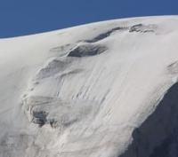
Glacier of Sugran.
Car travel in Pamir mountains.
“Glaciers hung like fringes into the gorges. Finally, the post-glacial period followed, in which we live today. The ice cover has shrunk and the glaciers have retreated. And again, countless millennia saw the play of winds and water. The heat from the plains was sucked up the mountain slopes and licked the glaciers, the melting streams of which, full of sand and silt, rolled into the valley. The upper layers of air, cooled by ice, fell down noisily, blowing out the finest dust from the glacial scree.”
Willie Rickmer Rickmers. Alai-Pamir expedition of 1928.
Drive from Dushanbe to Nurek.
Upper limit of Sugran glacier is located at an altitude of 6785 (Moscow peak) meters above sea level and 6467 (peak of 30th anniversary of Soviet State), end of glacier is located at an altitude of 3016 meters above sea level, is located on northern slope of Peter the Great ridge, bordered on eastern side with Fortambek glacier and in south with Gando glacier in Lakhsh region of Republic of Tajikistan.
The length of the glacier is 22 kilometers, the area of the Surgan glacier is 47.1 square kilometers. The Sugran Glacier is the largest glacier, a complex valley glacier, located in the upper reaches of the Surgan River, and is the basin of the Muksu River.
Its feeding area lies in the multi-chamber circuses at the base of Moscow Peak, 6785 meters above sea level. The Klebelsberg expedition in 1913 discovered the Sugran, Shini-Bini and Gando glaciers merged together. The end of the Sugran glacier was only 1.5 kilometers short of reaching the end of the Byrs glacier, while in 1974 the tongue of the Sugran glacier was 6 kilometers shorter.
This suggests that the glacial system in 1913 was larger in area not only than the entire system in 1974, but, as will be shown below, also the system in 2018. In the same year, 1913, which fell at the very end of the meridional northern circulation epoch, according to Dzerdzeevsky, the only pulsation of the Fedchenko glacier in the XXth century occurred (the glacier increased its area by 2 square kilometers, damming the bed of the Balyandkiik River) and the only pulsation of the Mushketov glacier in the XXth century. Both glaciers also belong to the Muksu River basin.
History of study of Sugran glacier.
This glacier was discovered and described by V.I. Lipsky in 1899. At that time, the glacier occupied almost the entire valley of the Sugran River and ended approximately 2 kilometers above the Byrs glacier. Based on morphological features, it was clear that these glaciers were connected quite recently.
In subsequent years, the glacier retreated and its tributaries were separated. Currently, the lower section of the glacier, 4.5 kilometers long, continues to degrade; it is covered with a moraine and dissected by numerous gullies. The Klebelsberg expedition in 1913 discovered the Sugran, Shini-Bini and Gando glaciers merged together.
The end of the Sugran glacier was only 1.5 kilometers short of reaching the end of the Byrs glacier, while in 1974 the tongue of the Sugran glacier was 6 kilometers shorter. This suggests that the glacial system in 1913 was larger in area not only than the entire system in 1974, but, as will be shown below, also the system in 2018.
In the same year, 1913, which falls at the very end of the meridional northern circulation epoch, according to Dzerdzeevsky, the only pulsation of the Fedchenko glacier in the XXth century occurred (the glacier increased its area by 2 square kilometers, damming the bed of the Balyandkiik River) and the only pulsation of the Mushketov glacier in the XXth century.
Both glaciers also belong to the Muksu River basin. The pulsating Sugran glacier is a complex glacier system consisting of four streams and two tributaries. It is located in the upper reaches of the river of the same name, in the basin of which there are also the famous pulsating glaciers Birs and Shini-Bini.
The literature notes three of its developments that took place in the XIXth century. The last of them was recorded in 1977 - 1980. based on the processing of materials from 13 repeated space surveys carried out from 1972 to 1991 using the KFA-1000 camera with a resolution of 5 - 10 meters.
The research was based on a joint analysis of the results of stereoscopic interpretation of changes in the size and structure of the glacier surface and measurements of the speed of ice movement using satellite images at different times. Using measurements, it was established that the morphological end did not advance - the glacier movement stopped within the remnants of dead ice of the former glacier tongue.
This forced us to classify the observed movement of the Sugran glacier as internal. The next information about the state of the glacier was obtained only 12 years later thanks to the analysis of ASTER space images (taken on August 8, 2003).
It can be seen that the situation on the glacier is similar to what took place 25 years ago, after the completion of the internal movement in 1977 - 1980: the end of the upper tributary, the Perevalny glacier (represented in the picture as a “drop”), again moved down the Sugran glacier and is located at the point where it flows into the main trunk of the lower tributary, the Vilka glacier.
It was obvious that another internal movement of the glacier had occurred. Due to the lack of photographs from previous years, it was not possible to accurately determine the location of the dynamic end of the Sugran glacier in 2003. However, stereoscopic viewing of ASTER images showed that the convex ("living") end of the tongue in August 2003 was approximately 2.5 kilometers above the valley of the Shini-Bini glacier, i.e. approximately in the same place as after the previous movement.
Geographic coordinates of Sugran glacier: N38°56'33 E71°44'41
Authority:
"Glaciers." L.D. Dolgushin, G.B. Osipova. Series "Nature of the world." Moscow, the publishing house "Thought". 1989.
Express information “Grand movement of the Sugran glacier in the Central Pamirs in 2003 - 2005. G.B. Osipova, D.G. Tsvetkov. Institute of Geography RAS, Moscow.
https://naukarus.com/grandioznaya-podvizhka-lednika-sugran-na-tsentralnom-pamire-v-2003-2005-g
Photos by:
Alexander Petrov.