


![]()
You are here
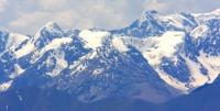
Glaciers of Kyrgyz Range.
Kyrgyz mountains Peaks expedition.
“The creation of a thousand forests is in one acorn”
Ralph Waldo Emerson.
Climb High Peaks of Kyrgyz Range.
The snow line on the Kyrgyz ridge rises from the periphery into the mountain system, in general, from the northwest to southeast. It is located at altitudes of 3600 - 3800 meters above sea level on the northern slopes and 3900 - 4200 meters above sea level - on the southern.
Glaciation is concentrated in the middle part of the ridge with heights up to 4700 - 4800 meters above sea level. In total, there are 607 glaciers on the Kyrgyz ridge with a total area of 530.4 square kilometers, and on its spurs, Kara-Moinok and Dzhumgal-Too ranges, 191 glaciers with an area of 59.4 square kilometers.
Almost 80% of the number of glaciers and 90% of the total area of glaciation are concentrated on the northern slope of the ridge. The glaciers themselves are much larger than on the southern slope. Most of the glaciers are concentrated in the basins of the Sokuluk, Alaarcha, Alamedin and Issyk-Ata basins, and there are 9 out of 12 glaciers larger than 5 square kilometers.
To the west and east of the basins of these rivers, the intensity of glaciation decreases. On the northern slope of the Kyrgyz ridge, there are as many glaciers as there are caravans and dangers, but they make up 82% of the total glaciation area.
Valley and hollow glaciers are usually located in the upper reaches of the main valleys, and valley glaciers are located in small lateral valleys. More than 25% of the surface area of all glaciers is covered with moraine.
The highest degree of glacier moraine in the western part of the ridge. Some are fully armored with moraine. The average height of the ends of the glaciers is 3650 meters above sea level, the Mayakovsky glacier goes down below all - up to 3070 meters above sea level.
The average height of the firn line is 3870 meters above sea level, in the eastern part of the ridge it rises to 4000 - 4100 meters above sea level. The largest glacier on the northern slope of the Kyrgyz Range is located in the Nouruz River Basin. Its length is 6.5 kilometers, an area of 10 kilometers square.
It has a four-chamber feeding area, the tongue is armored with a moraine ridge. On the southern slope of the Kyrgyz Range, 72% of all glaciers have an area of 0.5 square kilometers or less. The average height of the ends of the glaciers in the Naryn river basin is 3,500 meters above sea level, in the Chu river basin 3,760 meters above sea level.
The largest glacier on the southern slope is the Geofak hollow glacier (Tuyuk-Suu Yuzhny) (3.4 km long, 2.7 km square) in the upper Bash Alaarcha River. During the ablation period, a layer of ice from 2 to 5 meters thick melts on the glaciers of the Kyrgyz Range.
Ice speeds are small - 18-30 meters per year. A general retreat of a number of glaciers of the Kyrgyz ridge is observed. So, from 1917 to 1961, the Golubin glacier retreated by almost 1 km. The end of the Tushinsky glacier from 1906 to 1960 receded 600 meters, but by 1964 it advanced 34 meters.
In recent years, some signs of movement have been noted on other glaciers.
On the Kyrgyz ridge, about 600 glaciers, the area of glaciation is up to 500 square kilometers.
The largest glaciers of the northern slope of the Kyrgyz ridge.
The Top Karagai Glacier, with a length of 7.7 kilometers, an area of 6.4 square kilometers, located at an altitude of 3400 to 4460 meters above sea level, belongs to the Ala-Archa river basin.
Shopokov Glacier, with a length of 7.0 kilometers, an area of 8.8 square kilometers, located at an altitude of 3230 to 4875 meters above sea level, belongs to the Ala-Archa river basin
The Kurgaktor Glacier, with a length of 6.8 kilometers, an area of 3.2 square kilometers, located at an altitude of 3600 to 4520 meters above sea level, belongs to the Ala-Archa river basin.
Glacier No. 311, with a length of 6.5 kilometers, an area of 10.0 square kilometers, located at an altitude of 3300 to 4600 meters above sea level, belongs to the Nouruz river basin.
The Ak-Sai Glacier, with a length of 6.4 kilometers, an area of 4.4 square kilometers, is located at an altitude of 3220 to 4840 meters above sea level, belongs to the Ala-Archa river basin.
Glacier No. 279, with a length of 6.2 kilometers, an area of 4.1 square kilometers, located at an altitude of 3220 to 4870 meters above sea level, belongs to the Ala-Archa river basin.
The Tuyuk Glacier, with a length of 6.1 kilometers, an area of 8.5 square kilometers, is located at an altitude of 3400 to 4500 meters above sea level, belongs to the Ala-Archa river basin.
The Golubin Glacier, with a length of 5.6 kilometers, an area of 9.4 square kilometers, is located at an altitude of 3400 to 4420 meters above sea level, belongs to the Ala-Archa river basin.
The Tushinsky Glacier, with a length of 4.8 kilometers, an area of 3.8 square kilometers, located at an altitude of 3660 to 4600 meters above sea level, belongs to the basin of the Issyk-Ata River.
The Sergei Roerich Glacier, with a length of 4.8 kilometers, an area of 3.2 square kilometers, located at an altitude of 3320 to 4300 meters above sea level, belongs to the Alamedin River Basin.
The Vardanyants Glacier, with a length of 4.5 kilometers, an area of 5.2 square kilometers, is located at an altitude of 3710 to 4420 meters above sea level, belongs to the Issyk-Ata river basin.
Zabirova Glacier, with a length of 4.5 kilometers, an area of 3.1 square kilometers, located at an altitude of 3300 to 4875 meters above sea level, belongs to the Alamedin basin.
The Nikolai Roerich Glacier, with a length of 4.5 kilometers, an area of 3.0 square kilometers, located at an altitude of 3680 to 4120 meters above sea level, belongs to the Alamedin River Basin.
The Marechek Glacier, with a length of 4.3 kilometers, an area of 6.1 square kilometers, is located at an altitude of 3440 to 4030 meters above sea level, belongs to the basin of the Sokuluk River.
Fedorovich Glacier, with a length of 4.3 kilometers, an area of 5.0 square kilometers, located at an altitude of 3200 to 3990 meters above sea level, belongs to the basin of the Sokuluk River.
The Toktogul Glacier, with a length of 4.2 kilometers, an area of 5.5 square kilometers, located at an altitude of 3300 to 4460 meters above sea level, belongs to the Alamedin River Basin.
Belogorsky Glacier, 4.2 km long, an area of 3.6 square kilometers, located at an altitude of 3580 to 4250 meters above sea level, belongs to the basin of the Sokuluk River.
The Guzeli Glacier, with a length of 4.1 kilometers, an area of 2.8 square kilometers, is located at an altitude of 3580 to 4240 meters above sea level, belongs to the Jalamysh river basin.
The Tekovy glacier, with a length of 4.0 kilometers, an area of 2.3 square kilometers, is located at an altitude of 3570 to 4660 meters above sea level, belongs to the basin of the Issyk-Ata ..
The Alamedin Glacier, with a length of 3.9 kilometers, an area of 7.5 square kilometers, is located at an altitude of 3240 to 4430 meters above sea level, belongs to the Alamedin River Basin.
The Petrosyantsa Glacier, with a length of 3.8 kilometers, an area of 8.4 square kilometers, is located at an altitude of 3480 to 4280 meters above sea level, belongs to the Issyk-Ata river basin.
Glaciers No. 399 - 403, with a length of 3.6 kilometers, an area of 7.4 square kilometers, located at an altitude of 3250 to 4300 meters above sea level, belongs to the Shamsi river basin.
The largest glaciers of the southern slope of the Kyrgyz ridge.
Glacier No. 210, with a length of 3.4 kilometers, an area of 2.2 square kilometers, located at an altitude of 3100 to 4070 meters above sea level, belongs to the basin of the Karkol West.
The Geofaka Glacier, with a length of 3.4 kilometers, an area of 2.2 square kilometers, located at an altitude of 3100 to 4070 meters above sea level, belongs to the Western Karakol River Basin.
The largest glaciers on the slope of the Dzhumgal-Too ridge.
The Dzharkorumdu Glacier, with a length of 3.9 kilometers, an area of 5.0 square kilometers, located at an altitude of 3600 to 4155 meters above sea level, belongs to the Kochkor river basin.

Authority:
"Glaciers." L.D. Dolgushin, G.B. Osipova. Series "Nature of the world." Moscow, the publishing house "Thought". 1989.
Photos by
Alexander Petrov.