


![]()
You are here
Glaciers of Northern Tien-Shan.
Nature Kyrgyzstan Tours.
“The world`s history is constant, like the laws of nature, and simple, like the souls of men. The same conditions continually produce the same results”
Friedrich von Schiller.
Participation in photo tour in Kyrgyzstan.
Northern Tien-Shan includes the northern marginal ridges of the Tien-Shan mountain system: the Kyrgyz, Zailiysky Alatau and Kungey-Ala-Too, which, like the whole system, have a wide strike. The relief of the highlands of the Northern Tien-Shan is characterized by deep dissection and numerous traces of ancient glaciation.
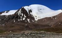
The ridges of the ridges for a considerable extent are above 4000 meters above sea level, and individual peaks rise to 4500 - 4900 meters above sea level. The highest point of the entire region is Talgar peak in the Zailiysky Alatau ridge.
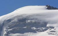
There are 1695 glaciers on the ridges of the Northern Tien Shan; their total area is 1493.1 square kilometers. Valley-type glaciers prevail (35% of the number and 78% of the area). Glaciers are confined mainly to the highest axial parts of the ridges and to the junctions of these ridges.
The Kyrgyz Range rises with a powerful wall over the Chuy Valley and stretches for almost 400 kilometers from the city of Taraz to the Boom Gorge, where the Chu River flows. Glaciation is concentrated in the middle part of the ridge with heights up to 4700 - 4800 meters above sea level.
The highest point is the peak of West Alamedin, 4875 meters above sea level. In total, there are 607 glaciers on the Kyrgyz ridge with a total area of 530.4 square kilometers, and on its spurs, Kara-Moinok and Dzhumgal-Too ridges, 191 glaciers with an area of 59.4 square kilometers.
Almost 80% of the number of glaciers and 90% of the total area of glaciation are concentrated on the northern slope of the ridge. The glaciers themselves are much larger than on the southern slope. Most glaciers It is concentrated in the basins of the Sokuluk, Alaarcha, Alamedin and Issyk-Ata rivers, and there are 9 of 12 glaciers larger than 5 square kilometers.
To the west and east of the basins of these rivers, the intensity of glaciation decreases. On the northern slope of the Kyrgyz ridge, there are as many glaciers of valleys as they make up 82% of the total area of glaciation.
Valley and valley glaciers are usually located in the upper reaches of the main valleys, and valley glaciers are located in small lateral valleys. Many hanging valley glaciers and glaciers with asymmetric power. In the basins of the Issyk-Ata and Alamedin rivers there are several revived glaciers.
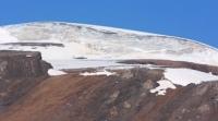
More than 25% of the surface area of all glaciers is covered with moraine. The highest degree of glaciers with moraine covered in the western part of the ridge. Some are fully armored with moraine. The average height of the ends of the glaciers is 3650 meters above sea level, below Mayakovsky glacier descends to all - to an altitude of 3070 meters above sea level.
The average height of the firn line is 3870 meters above sea level, in the eastern part of the ridge it rises to an altitude of 4000 - 4100 meters above sea level. The largest glacier on the northern slope of the Kyrgyz Range is located in the Nouruz River Basin. Its length is 6.5 kilometers, area
10.0 square kilometers. It has a four-chamber feeding area, the end of the glacier is armored with a moraine cover. On the southern slope of the Kyrgyz Range 129 glaciers with an area of 59.2 square kilometers. 72% of all glaciers have an area of 0.5 square kilometers or less.
The average height of the ends of the glaciers in the Naryn river basin is 3,500 meters above sea level in the Chu river basin is 3,760 meters above sea level. The height of the firn line is 3620 and 3940 meters above sea level, respectively.
The largest glacier of the southern slope is the Geofak hollow glacier (3.4 km long, 2.7 km square) in the headwaters of the Bash Alaarch river (Naryn river basin). During the ablation period, a layer of ice from 2 to 5 meters thick melts on the glaciers of the Kyrgyz Range. Ice speeds are small - 18 - 30 meters per year.
On the Golubin Glacier, with a length of 5.1 kilometers, an area of 6.2 kilometers square, which is located in the Alaarcha river basin, balance observations have been carried out since 1960. This is a glacier of a hanging valley, the average slope of its surface is 9 °.
The highest point of glacier 4350 meters above sea level, the firn basin is separated from the end of the glacier by an icefall. The tongue is clean descends to 3250 meters above sea level, the height of the border of the glacier is 3870 meters above sea level.
Between 1960 and 1982 At the glacier snout, an average of 690 mm fell, and in the firn region - 840 mm of precipitation per year. Over the same period, the average annual accumulation was 75.8 grams per square centimeter, the ablation was 77.2 g / cm2, and the mass balance was 1.4 g / cm2 per year.
The total mass balance over 23 years was -31.7 g / cm2 (Aizin. 1985). A general retreat of a number of glaciers of the Kyrgyz ridge is observed. So, from 1917 to 1961, the Golubin Glacier retreated by almost 1 kilometer, the Sovetkina Glacier in the Alamedin River Basin - by 360 meters.
The end of the Tushinsky glacier from 1906 to 1960 receded 600 meters, but by 1964 it advanced 34 meters. In recent years, signs of an offensive have been noted on other glaciers.
Authority:
"Glaciers." L.D. Dolgushin, G.B. Osipova. Series "Nature of the world." Moscow, the publishing house "Thought". 1989.
Photos by
Roman Stesenko.