







You are here
Glaciers in Left Talgar river basin.
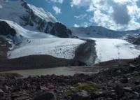
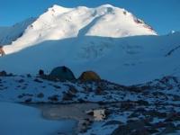
Weekend tour along valley of Left Talgar River.
“In the Talgara River basin, the largest glaciers, reaching a length of 4-6 km, are: the Dmitriev glacier (named after one of the first and fruitful researchers of the Trans-Ili glaciers), the Shokalsky glacier (named after the luminary of Soviet geography Yu. M. Shokalsky), the Constitution glacier, Toguzak and the Kalesnik glacier (named after the famous geographer). The Dmitriev Glacier is distinguished by its considerable width in its upper reaches, which reaches up to 5 km there. The Shokalsky Glacier is remarkable for this. that its Khan descends into the valley below all the glaciers of the ridge, to an altitude of 3270 m. u. m. In addition, on this glacier one of its branches has a picturesque and grandiose icefall. The Constitution and Toguzak glaciers, lying next to each other and not so long ago forming one whole, are the most typical valley glaciers of the ridge. The Kolesnika glacier attracts attention with its picturesque icefalls and steep wall-like end abutting a small moraine lake.”
Nikolai Nikitich Palgov. “Nature of Kazakhstan in essays and pictures.” 1950
Tributaries of Talgar River.
Basin of Left Talgar River.
Talgar is formed from two branches - Eastern, or Right Talgar, and Western, or Left Talgar. Another branch flows into the right branch, near its confluence with the left - the Middle Talgar, or Varakin Spring. The water content of each of the three Talgars is related to both the drainage area and the area of glaciation.
In accordance with this, the greatest degree of glaciation is observed in the river basin. Left Talgar. 33 glaciers with a total area of 83 sq. m. are taken into account here. km. in second place is the Middle Talgar basin, where there are 19 glaciers with an area of 38 sq. km.
The least glaciation is observed in the upper reaches of the Right Talgar, where six glaciers with an area of 9 sq. m. are so far known. km. The Talgar River basin is characterized by the highest degree of glaciation in the entire Zailiskiy Alatau.
The largest glaciers lie at the source of the Left Talgar, at the head section of its valley.
This area is a basin closed on the rear and eastern side by the main ridge of the Trans-Ili Alatau, and on the west by the Big Almaty spur, which passes into the Small Almaty spur in the north. On the rear side of the basin rises the nodal peak of the Chilik-Kemin node - the CDKA peak.
To the east stands the massive Constitution Peak. From this peak, the rear ridge first gradually and then sharply deviates to the north, where, near a new turn to the east and southeast, it bears the highest peaks, led by Talgar Peak. The basin lies at a depth of one kilometer or more from the surrounding watersheds. Its width at the top reaches 11-12 km.
In several places the basin is blocked by short spurs of mountains, forming reservoirs of different capacities between themselves, occupied by glaciers. The latter give rise to the three sources of the main river - Tourists, Constitution, Mynzhilka.
The first two sources are the main components of the Left Talgar River, and the third is Mynzhilki.
Geographic coordinates of Left Talgar River: N43°08'18 E77°09'13
Glacier of Tourists in upper reaches of Left Talgar River.
It was first visited in 1936 by V.G. Gorbunov, who gave it its name. The Turistov Glacier occupies the northern slope of a side spur extending from the Molodaya Gvardiya massif (Big Almaty spur) to the east, deep into the left Talgar basin. The peak of SSU (Sverdlovsk State University) with a height of 4522 m stands out on this spur.
The glacier belongs to the type of trail glaciers of the slope. It starts at an average altitude of 4220 m and ends with the open part of the tongue at an altitude of 3560 m, and the buried part at approximately 3400 m. Its exposure is first northern, then northeastern and finally eastern.
The glacier has a length of 4 km along the firn field - 0.6 km, along the open part of the tongue - 2.2 km and along the buried part - 1.2 km. The area of the firn field is 2.7 sq. km., open tongue with lateral moraines - 4.0 sq. km., buried section: 1.0 sq. km; total area: 7.4 sq. km.
Positive glaciation difference: 314 m; negative difference: 346 m. Glaciation coefficient: approximately 0.7.
Geographic coordinates of Turistov Glacier: N43°01'17 E77°06'20
Sovetskikh Alpinistov Glacier in Levy Talgar Gorge.
The glaciers located in the basin of the Konstitutsii River - which occupies the southern (central) part of the basin - are Sovetskikh Alpinistov, Dmitrieva, Konstitutsii, and Toguzak. Sovetskikh Alpinistov Glacier originates in a broad, high-altitude cirque situated southwest of SGU Peak.
In its upper reaches, the glacier appears stunted due to recession, while its lower section forms a wide band of ice densely strewn with granite debris. Essentially, it is a detached section of the adjacent Dmitrieva Glacier (located to the south); it is separated from the latter by a short rocky ridge at its head and by a large medial moraine ridge in the area of its terminus.
Geographic coordinates of Sovetskikh Alpinistov Glacier: N43°01'22 E77°05'36
Dmitrieva Glacier in upper reaches of Levy Talgar River.
It was first visited in 1936 by V. G. Gorbunov, who named it in honor of S. E. Dmitrieva, a pioneer researcher of the Zailiysky Alatau glaciers. It is the largest glacier in the entire Levy Talgar basin. In terms of type, it is best classified as a cirque-basin glacier.
The glacier originates at the main ridge crest, featuring a 4,468-meter peak at its center; to the east lies TsDKA Peak, and further still, in the southeastern corner, stands Constitution Peak. The Dmitriev Glacier generally faces northeast. The average elevation of its cirque's headwalls is 4,350 m; the lowest section of the exposed tongue lies at 3,550 m, while ice buried beneath moraine deposits can be traced down to 3,300 m and below.
As of 1940, the lengths were as follows: firn field - 1.6 km; exposed tongue - 3.3 km; buried section - 1.7 km; total glacier length - 6.6 km. The surface areas were: firn field - 11.5 sq. km.; exposed tongue - 6.1 sq. km.; buried section - 3.3 sq. km.; total glacier area - 20.9 sq. km.
The positive vertical range of the glacier is 403 m, and the negative range is 397 m. The glacier coefficient is 1.9. Short spurs divide the upper reaches of the glacial cirque into eight chambers of varying sizes, resembling individual cirques. These serve as the glacier's primary accumulation zones, receiving snow that slides down the enclosing slopes, falls via avalanches, or is deposited by the wind during blizzards.
Below the firn line, these "partitions" disappear, and the basin containing the glacier narrows. In cross-section, it forms a trough with asymmetrical sides and an uneven floor. At the terminus of the tongue, the basin narrows to one kilometer and transitions into a valley shape extending northeast.
Flowing from cirques as distinct branches, the glacier merges into a single channel at an elevation of approximately 3,850 m. Separate spurs remaining above this elevation give rise to medial moraines; there are three such moraines in the middle section of the tongue and five in the lower section.
Ridges of ice covered by these moraines stand 2 to 5 meters high. They give the glacier the appearance of being divided into a series of at least six parallel, similar lobes. The terminus of the tongue has an average gradient of about 10°. On the left side, the slope gradually steepens to 30°, while ice cliffs occur on the right.
Large bulges and isolated depressions are visible on the surface of the tongue. Small transverse crevasses appear in the 3,630-3,700 m elevation range. They occur somewhat more frequently - within a similar elevation range (3,600-3,650 m) - on the easternmost lobe.
Groups of crevasses are also found near the firn field. Basin-like depressions exist in places on the glacier surface. A deep basin containing a small lake is located near the start of the left medial moraine. Glacial moulins are occasionally observed in the crevassed areas, and deep erosional channels appear in the lowest part of the tongue.
The glacier terminates in the valley with six "tails." The two on the left and the one on the far right are the largest. The remaining three - and especially the middle one - are notable for their narrow width (up to 50 m). The exposed terminus of the glacier descends, on average, to an elevation of 3,560 m.
The bodies of buried ice begin directly at the end of the glacier tongue as a narrow ridge that widens as it extends into the valley. Melting of the ice beneath the moraine cover has created numerous hollows and collapse depressions within them. In the largest and deepest depressions at an absolute altitude of about 3400 m, three lakes located close to each other are nestled. The buried part of the glacier at an altitude of 3300 m is interrupted by a glacial stream that goes around its foot.
Geographic coordinates of Dmitriev Glacier: N42°59'12 E77°06'22
Constitution Glacier in upper reaches of Left Talgar River.
To the east, next to the Dmitriev Glacier, is the Constitution Glacier. The upper reaches of the firn fields of both come together on the ridge separating them, i.e. are saddlebags. The remaining parts of the firn fields and tongues are separated by a rocky continuation of this ridge.
The Constitution Glacier was first discovered by S.E. Dmitriev in 1910 while traveling from the Chilik valley to the Left Talgar valley. Constitution valley glacier. The snow-covered ridges of its rear part rise on average to 4420 m. The most significant peaks are: in the southwestern corner of the cirque - Constitution Peak (4580 m) and near the eastern corner - height 4542 m.
The tongue of the glacier has a northern exposure and belongs to one of the lowest lying in the entire Trans-Ili Alatau.
Geographic coordinates of Constitution Glacier: N42°59'34 E77°10'28
Toguzak glacier in upper reaches of Left Talgar River.
To the northeast of the Toguzak spur, the Toguzak glacier is located in two wide gorges. It got its name from the Toguzak saddle, located on the rear ridge of the right one of the gorges it occupies. Since its width in the upper reaches is only one and a half to two times less than its total length, it can be classified as a type of semi-basin glaciers with a well-defined valley mouth.
The glacier consists of two main branches, originating from independent circuses. The largest branch is the left one. It includes two more small hanging glaciers and one large-falling tributary, all three are located on the slopes of the Toguzak spur.
Both branches begin at an average altitude of 4450 m. The left one, protruding forward several hundred meters, lies with its open end at an altitude of 3525 m. Its buried part extends even lower, merging with the buried part of the Constitution Glacier.
The languages of both branches have Western exposure. (N. N. Palgov, 1958). The described glaciers exhaust the main area of glaciation in the main sources of the river. Left Talgar. In number, these glaciers make up about half of all known glaciers in the basin of this river, and in area - more than three quarters.
The remaining glaciers of the Left Talgar belong to its tributaries. One group of these glaciers is confined to the Small Almaty spur and the Komsomolsky spur extending from the latter in a parallel direction. In the upper reaches of the gorge formed by these spurs lies the Bogdanovich glacier, which belongs to the valley type.
On the western slopes of the Komsomol spur, north of the Bogdanovich glacier, there are the Til and Ayak, Fizkulturnik and Chkalova glaciers. All these glaciers are of the hanging type, with the Fizkulturnik glacier being the smallest in the river basin.
On the eastern slopes of the Small Almaty and Komsomol spurs there are glaciers: South-Eastern and Eastern Ordzhonikidze, which belong to the type of cirques with long trains of moraine deposits stretching along the slope, Kyrlytau, Aristova and Komsomolets.
Geographic coordinates of Toguzak glacier: N43°00'50 E77°13'17
References:
Gvozdetsky N. A., Nikolaev V. A. *Kazakhstan*. Moscow: Mysl, 1971.
Gvozdetsky N. A., Mikhailov N. I. *Physical Geography of the USSR*. Moscow: Mysl, 1978.
Zhivago N. V., Piotrovsky V. V. Geomorphology with Fundamentals of Geology. Moscow: Nedra, 1971.
Catalogue of Glaciers of the USSR. Leningrad, 1967, Vol. 13, Issue 2, Part 1.
Catalogue of Glaciers of the USSR. Leningrad, 1967, Vol. 13, Issue 2, Part 2.
Tuyuksu Glaciers (Northern Tien Shan). Leningrad: Gidrometeoizdat, 1984.
Glaciation of the Tien Shan. Ed. N. B. Dyurgerov. Moscow, 1995.
"Glaciation of the Zailiysky Alatau." Moscow: Nauka, 1969
Palgov N. N. The Bolshaya Almatinka Glaciation Cluster in the Zailiysky Alatau Range. *Izvestiya Vsesoyuznogo geograficheskogo obshchestva* [Proceedings of the All-Union Geographical Society], 1948, Vol. 80, Issue 1.
Palgov N. N. Shokalsky Glacier in the Zailiysky Alatau Range. "Izvestiya Vsesoyuznogo geograficheskogo obshchestva" (Proceedings of the All-Union Geographical Society), 1948, Vol. 80, Issue 1.
Palgov N. N. Trip to the Tuyuksu Glacier in the Summer of 1922 (Offprint from *Izvestiya GRGO*, Vol. LVIII), 1926.
Tokmagambetov G. A. Glaciers of the Zailiysky Alatau. Alma-Ata, 1976.
Tokmagambetov G. A. Secrets of Kazakhstan's Natural Ice. Alma-Ata: Nauka, 1978.
Svarichevskaya Z. A. "Geomorphology of Kazakhstan and Central Asia". 1965.
Chedaya O. K. "Morphostructures and Recent Tectogenesis of the Tien-Shan". Frunze: Ilim, 1986.
Material prepared using data from:
Glaciological studies and works by scientists: S. E. Dmitrieva, N. N. Palgova, G. A. Tokmagambetova (*Glaciers of the Zailiysky Alatau*, 1976), K. G. Makarevich, and E. N. Vilesov.
Article: "Glacial Structures of the Northern Tien Shan – Zailiysky Alatau."
http://www.bigmir.net
https://elib.rgo.ru/safe-view/123456789/226999/1/0LPQtdC+0LsuMjRfVGFsZ2FyLCBnbGF2bmF5YSB2ZXJzaGluYSBaYWlsaWlza29nbyBBbGF0YXUsIGJsaXoucGRm
Photos by:
Alexander Petrov.