


![]()
You are here
Glaciers of Meridional Range.
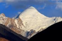
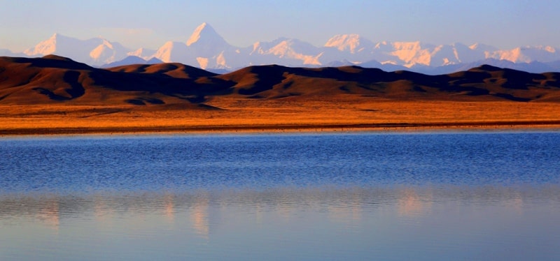
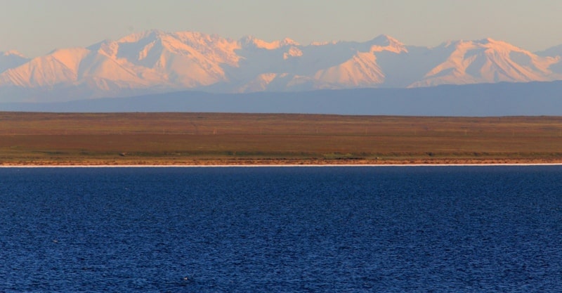
Natural Wonders of Kyrgyzstan.
“Why do you go away? So that you can come back. So that you can see the place you came from with new eyes and extra colors. And the people there see you differently, too. Coming back to where you started is not the same as never leaving”
Terry Pratchett. “A Hat Full of Sky”.
Landmarks of Kyrgyzstan.
The Meridional ridge is an obstacle to the air masses coming from the west. Rainfall increases with height and from west to east. At the Semenov glacier at an altitude of 3285 meters above sea level, an average of 760 mm of precipitation falls annually, and in humid years, up to 1000 mm or more.
Maximum precipitation (75 - 80%) occurs in May - August. At altitudes of more than 4000 meters above sea level, precipitation occurs only in solid form. Constant winds create intense snow transport, resulting in many snow cornices on the eastern side of the ridges.
In the highlands there are very low average annual air temperatures and insignificant positive in the summer. The high dryness of the air contributes to the intense evaporation of snow and ice. Huge absolute heights, large rugged terrain and harsh climate create favorable conditions for the development of powerful glaciation in the area.
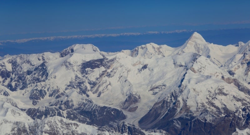
In total, in the Central Tien-Shan in the territory of Kyrgyzstan and Kazakhstan, there are 707 glaciers with a total area of 1,687.3 square kilometers. A characteristic feature of the glaciation of this region is the presence of large dendritic and complex valley glaciers occupying the upper reaches of the main longitudinal valleys.
The largest of them are the Southern and Northern Inylchek glaciers in the upper reaches of the Inylchek river and the Kaindy glaciers (Kaindy river), Mushketova (Adyr-tor river) and Semenova (Sary-Jazz river).
These 5 glaciers account for more than half of the total area of glaciation.
Smaller and simpler valley glaciers are located in the upper reaches of the lateral valleys mainly on the northern, wider and dissected slopes of the ranges. Among simple valleys there are many glaciers of the Turkestan type, especially in the western and southern parts of the region, receiving the main food from avalanches and landslides of snow and firn from the slopes.
Avalanches play an important role in feeding large complex valley glaciers of the northern slope of the Sary-Jaz ridge in the Tekes river basin. Hanging glaciers are widespread. In the upper reaches of the valleys, they form a second tier, located on slopes that rise above the surface of the main glacier.
In the lower western parts of the ranges, glaciers of these types prevail. The height of the firn line increases from west to east and from south to north from 3,900 to 4,000 meters above sea level to 4,500 to 5,000 meters above sea level and above.
On the southern slopes the firn line is 200-300 meters high, sometimes 600-700 meters higher than on the northern ones.The average annual accumulation on glaciers ranges from 20 to 100 g / cm2. The ablation period lasts 2 - 2.5 months depending on the weather, and the average stagnation is 70 - 250 g / cm2.
The speed of ice movement in the glaciers of the Central Tien Shan is less than that of the same type of glaciers in other mountain systems, from 2 - 7 m / year on glaciers of hanging and flat peaks to 40 - 150 m / year on large valley and dendritic glaciers.
In this regard, the full mass turnover in glaciers requires a lot of time. For example, on the South Inylchek glacier - 460 years, Semenova - 840 years (Bakov. 1983). Glaciers of the northern slope of the eastern part of the Terskey-Ala-Too ridge and the Sary-Jaz ridge and the western slope of the Meridional ridge give runoff to the rivers of the Balkhash Lake basin - Ashutor and Tekes.
In total there are 133 glaciers with a total area of 140.9 square kilometers. In the Ashutor river basin, glaciation is mainly of the valley type, valley glaciers appear only at the source of the river, where the ridge reaches 4645 meters above sea level.
The largest glaciers are located in the headwaters of the Tekes River on the northern slope of the Sary-Jaz ridge. The complex valley glaciers of Simonov, Marmara Wall and Sauruksaysky are located here, which feed on large firn fields complicated by ice falls and have low descending (up to 3350 meters above sea level) gently sloping glacier ends.
The vertical range of these glaciers is up to 2060 meters. An important role in their nutrition is played by avalanches. The average height of the ends of simple valley glaciers is 3550 meters above sea level. The surface of their tongues is characterized by ablative relief forms - ice tables, honeycombs, glasses, etc.
From 1953 to 1963, the Simonov, Bayankol and Marmara Wall glaciers retreated at a speed of 13 - 16 meters per year. Medium and small glaciers were stationary. In the basin of the Sary-Jazz River within the Central Tien-Shan there are 574 glaciers with a total area of 1,546.4 square kilometers.
The Sary-Jazz River originates from the Semenov dendritic glacier, which originates on the slopes of Semenov peak, 5816 meters above sea level at the junction of the Terskey-Ala-Too and Sary-Jazz ranges.
Avalanches play an important role in the nutrition of the glacier. To the left, 5 large tributaries flowing from the northern slope of the Adyrtor ridge into the Semenov glacier.
heir tongues on the surface of the main the trunk is bordered by stained ridges. On the right, from the southern slope of the Terskey-Ala-Too ridge, only two small tributaries flow into the glacier. The tongue of the Semenov glacier is gentle, its surface is covered with funnels resembling karst, with a diameter of up to 30 - 50 meters.
In some, meltwater accumulates, forming lakes. Melting in the tongue of a glacier at an altitude of 3700 meters above sea level averages 2.5 centimeters per day during the ablation period, and the maximum is up to 8 - 10 centimeters per day.
Mushketov Glacier. At the head of the Adyrtor River, the left tributary of the Sary-Jaz River, is the Mushketov Glacier, with a length of 20.5 kilometers and an area of 68.7 square kilometers. His firn region lies in a huge gorge with high (up to 1.5 kilometers) steep sides.
Tributary glaciers flowing into the main glacier from the northern slope of the Sary-Jaz ridge are bordered by moraines and have the characteristic appearance of “lion paws”. Until 1956, the glacier receded, and the ice of its lower part was practically motionless, but by August 1957 the end of the glacier quickly advanced 4.5 kilometers.
At the same time, its surface was covered with a dense network of cracks for several kilometers from the end, and the inflows of the lower course were blocked. Since then, the end of the glacier recedes (Osmonov. 1974).
In the western part of the Sary-Jaz ridge, small valley and cara-valley glaciers and slope glaciers predominate. In the basin of the Inylchek River, the left tributary of the Sary-Jaz River, there are 198 glaciers with a total area of 946.1 square kilometers.
South Inylchek Glacier. In the upper reaches of this river is the South Inylchek glacier, with a length of 60.5 kilometers, an area of 567.2 square kilometers - the largest Tien Shan glacier and the second largest mountain glacier in Central Asia after the Fedchenko glacier in Pmir.
The glacier originates from several huge firn pools. A glacier 43.2 kilometers long with an average width of 2.2 kilometers descends to an altitude of 2800 meters above sea level with an average surface slope of 2 °.
The bottom 14 kilometers of the end of the glacier are under the moraine. The thickness of the ice in this part of the glacier is 150 - 200 meters. The South Inylchek glacier system consists of 78 tributary glaciers of different orders.
The South Inylchek Glacier was discovered in 1876 by an expedition of the Russian Geographical Society. Subsequently, it was repeatedly visited by scientists and climbers, who noted the continuous degradation of the glacier, which was expressed in lowering the surface and segregation separate tributaries from the main glacier trunk.
The largest of them flow from the northern slopes of the Kakshaal-Too ridge. These are complex valley glaciers: Zvezdochka, an area of 87.4 square kilometers, Wild. with an area of 31.9 kilometers square, Proletarian Tourist, with an area of 47.3 kilometers square, Komsomolsky with an area of 68.1 kilometers square, Shokalsky with an area of 24.2 kilometers square and
others.
Glacier Zvezdochka. The largest of the southern tributaries to the South Inylchek glacier is the glacier - Zvezdochka glacier. Its main firn basin is located at the base of the highest point Tien-Shan - Pobeda Peak, 7439 meters above sea level.
32.8 kilometers long North Inylchek glacier, an area of 181.2 square kilometers, formerly merged with the South Inylchek glacier, and is now connected to it by a piece of dead ice, which is the bottom of the Merzbacher Lake.
Merzbacher Lake. Merzbacher Lake is located at the mouth of the North Inylchek Glacier Valley behind the ice dam formed by the end of the South Inylchek Glacier. At a high level, the area of the lake 4.5 square kilometers, a length of about 4 kilometers, an average width of about 1 kilometer, the volume of water in the lake is about 200 million cubic meters.
The bed of the lake is dead ice, buried under a 5 - 6-meter thickness of lake sediments. The lake is formed annually. It is fed by the meltwater of the North and South Inylchek glaciers and icebergs, breaking off the cliff of the right side of the South Inylchek glacier, as well as from a glacier located on the right side of the valley and breaking off directly into the lake.
The lake reaches its maximum size at the end of the ablation period and erupts inside the South Inylchek glacier annually, sometimes twice a year, most often in late August - early September (Avsyuk. 19506; Ayrapet Bakov. 1971).
In the narrow lateral valleys of the northern slope of the Engylchek-Too ridge there are small glaciers with cracks and icefalls that do not reach the bottom of the Inylchek river valley. Only the largest of them flows into the valley from gray ice from the moraine polluting it.
Kaindy Glacier. Next to the south of the Inylchek River, the Kaindy River flows into the Sary-Jaz River. There are 113 glaciers in the basin of this river with a total area of 151.3 square kilometers. At the head of the Kaindy River is the Kaindy Glacier, with a length of 29.0 kilometers and an area of 84.1 square kilometers.
Its feeding area occupies two huge circuses at an altitude of more than 5500 meters above sea level and, through a low ice section, connects to the feeding area of the Komsomolsky glacier, a tributary of the South Inylchek glacier.
The end of the glacier with a thickness of about 170 meters with a wide blade descends to an altitude of 3400 meters above sea level. Between 1943 and 1960, the end of the glacier advanced 1.3 kilometers, and in 1960 its surface was a chaotic pile of acute-angled ice blocks.
Further advancement of the glacier ceased, and after 5 years its surface became much smoother (Osmonov. 1974). At present, the lower 10 kilometers of the glacier are under the moraine, there are many hillocks on its surface, many of which are filled with water, which indicates degradation of the glacier after movement.
To the south of the Kayyngdy-Katta ridge is the valley of the Kuyukap River, which is a narrow gorge with sheer walls. Only in the upper reaches it expands, and there are large glaciers. In total, there are 45 glaciers in the Kuyukap river basin with an area of 76.8 square kilometers.
Kuyukap Glacier, with a length of 12.9 kilometers, an area of 18.4 square kilometers The firn region, located in a huge glacial gorge, is connected through the pass with the main stream of the Komsomolsky glacier.
Small glaciers are located on the Maybashtau ridge and on the western slope of the Kakshaal-Too ridge, in the upper reaches of the Sarytor, Dzhamansu and Dzhangiger rivers. In total there are 33 glaciers with a total area of 30.5 square kilometers.
In general, the glaciation of the Central Tien-Shan is reduced. This is evidenced by fresh moraine ridges, subsidence terraces, buried sections of dead ice. Many tributaries of large glaciers have recently separated from them, and some are in the process of separation.
Semenov Glacier from 1885 retreated by almost 3 kilometers. The speed of linear reductions in most large glaciers is 2 - 10 meters per year. Small glaciers almost did not change their outlines and for the most part are stationary or close to its position (Bakov. 1983; Dikikh. 1976; Zabirov. 1958, 1962) (Dolgushin, Osipova, Rototaeva. 1972; Vinogradov, Konovalova, Psareva 1980; Catalog of Glaciers. 1967 - 1979).
The southern part of the Meridian Range is the largest site of modern glaciation. From the slopes of the Meridional Range, the glacier North Engilchek and the eastern source of the glacier South Zngilchek flow. The northern part of the Meridian Range is reduced to 4000 meters above sea level, but also carries more than 30 glaciers.
The largest glaciers of the Meridional Range and the Tengri-Tau spur.
The South Enylchek Glacier, with a length of 59.5 kilometers, an area of 223.6 square kilometers, located at an altitude of 2800 to 6870 meters above sea level, belongs to the Sary-Jazz River Basin.
Glacier North Inylchek, with a length of 32.8 kilometers, an area of 90.7 square kilometers, located at an altitude of 3400 to 6995 meters above sea level, belongs to the basin of the Sary-Jazz River.
Glacier No. 140, with a length of 7.9 kilometers, an area of 16.4 square kilometers, located at an altitude of 4800 to 6600 meters above sea level, belongs to the basin of the Sary-Jazz River.
The Marble Wall Glacier, with a length of 7.8 kilometers, an area of 22.5 square kilometers, located at an altitude of 3390 to 6150 meters above sea level, belongs to the Keskentas River Basin.
The Razorvanyi Glacier, 1.1 km long, covers an area of 12.0 square kilometers, located at an altitude of 4800 to 6280 meters above sea level, belongs to the Sary-Jazz River Basin.
The Sukhodolsky Glacier, with a length of 6.1 kilometers, an area of 9.6 square kilometers, is located at an altitude of 3800 to 6050 meters above sea level, belongs to the basin of the Sary-Jazz River.
Semenovsky Glacier, with a length of 5.8 kilometers, an area of 16.7 square kilometers, located at an altitude of 4480 to 6995 meters above sea level, belongs to the basin of the Sary-Jazz River.
The Sauraksai Glacier, with a length of 5.1 kilometers, an area of 7.1 square kilometers, located at an altitude of 3640 to 5480 meters above sea level, belongs to the Keskentas River Basin.
Glacier No. 96, with a length of 5.1 kilometers, an area of 7.1 square kilometers, located at an altitude of 3640 to 5480 meters above sea level, belongs to the Sary-Jazz River Basin.
Glacier No. 86, with a length of 5.0 kilometers, an area of 5.1 square kilometers, located at an altitude of 3920 to 6050 meters above sea level, belongs to the basin of the Sary-Jazz River.
Glacier No. 91, with a length of 5.0 kilometers, an area of 5.1 square kilometers, located at an altitude of 3740 to 5480 meters above sea level, belongs to the basin of the Sary-Jazz River.
Yevgeny Abalakov glacier, 4.7 kilometers long, 7.3 square kilometers in area, located at an altitude of 4150 to 6370 meters above sea level, belongs to the Sary-Jazz River Basin.
Glacier Ledovyi poyas, the 4.7 km long ice belt, an area of 3.6 square kilometers, located at an altitude of 3870 to 5480 meters above sea level, belongs to the Sary-Jazz River Basin.
Glacier No. 98, with a length of 4.4 kilometers, an area of 4.4 square kilometers, located at an altitude of 3480 to 5860 meters above sea level, belongs to the basin of the Sary-Jazz River.
Glacier No. 100, with a length of 4.4 kilometers, an area of 2.7 square kilometers, located at an altitude of 3700 to 5100 meters above sea level, belongs to the basin of the Sary-Jazz River.
Glacier No. 103, with a length of 4.3 kilometers, an area of 3.9 square kilometers, located at an altitude of 3,500 to 5,480 meters above sea level, belongs to the Sary-Jazz River Basin.
Glacier No. 104, with a length of 4.3 kilometers, an area of 3.8 square kilometers, located at an altitude of 3440 to 5210 meters above sea level, belongs to the basin of the Sary-Jazz River.
Glacier No. 99, with a length of 4.3 kilometers, an area of 3.1 square kilometers, located at an altitude of 3,500 to 5,480 meters above sea level, belongs to the Sary-Jazz River Basin.

Authority:
"Glaciers." L.D. Dolgushin, G.B. Osipova. Series "Nature of the world." Moscow, the publishing house "Thought". 1989.
Photos by
Alexander Petrov.