


![]()
You are here
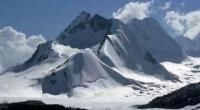
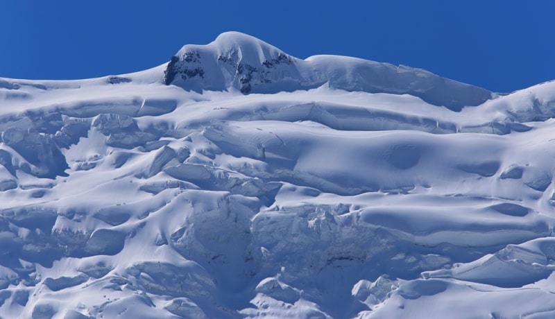
Glaciers in ridge of Peter the Great.
Pamir Tour in Tajikistan.
"Three things make a person happy: love, an interesting job, and the opportunity to travel."
Bunin I.A.
Rock tour Tajikistan.
The ridge of Peter I departs from the ridge of the Academy of Sciences in the area of the peak of Communism. The length of the ridge is 200 kilometers, the highest point of the ridge is Moscow peak, 6785 meters above sea level.
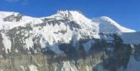
A characteristic feature of the relief of the ridge of Peter I are the remains of ancient flat surfaces raised to a great height, along the edges there are blockages from the trees torn out from the root. In subsequent years, the advanced part of the glacier melted intensively (Dolgushin, Osipova. 1971).
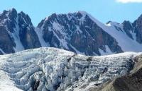
In 1983 - 1984 there was a new rapid movement of the Muzgazy glacier (Desinov. 1984). Significant glaciation is confined to the Sugran river basin (37 glaciers with an area of 94.2 square kilometers). Sugran Glacier is located in the Murgab district of the Gorno-Badakhshan Autonomous Region of Tajikistan.
The length of the glacier is 22 kilometers, the area of the Surgan glacier is 47.1 square kilometers. Sugran Glacier is the largest glacier, a complex valley, located in the upper reaches of the Surgan River, is the basin of the Muksu River.
Its feeding area lies in multi-chamber circuses at the base of Moscow peak at a height of 6785 meters at sea level. This glacier was discovered and described by V.I. Lipsky in 1899. At that time, the glacier occupied almost the entire valley of the Sugran River and ended about 2 kilometers above the Byrs Glacier.
According to morphological characteristics, it was evident that recently these glaciers were connected. In subsequent years, the glacier retreated, the tributaries were separated from it. Currently, the lower section of the glacier with a length of 4.5 kilometers continues to degrade, it is covered with moraine and dissected by numerous gullies. In the middle course, the glacier takes two large tributaries on the left - the Perevalny and Vilku glaciers.
These are active steep glaciers, whose languages, pouring into the Sugran glacier, push its flow to the starboard side and can be traced far downstream, bordered by middle moraines. Over the past decade, these glaciers have been actively advancing.
From 1972 to 1977, the front of the Vilka Glacier advanced 0.6 km downstream of the Sugran Glacier, and another 1.2 kilometers by 1980. The advance of the Perevalniy glacier was less significant. These advances increasingly block the Sugran glacier and violate its regime.
The Shini-Bini Glacier is located in the Murghab region of the Gorno-Badakhshan Autonomous Region of Tajikistan. The length of the glacier is 10.3 kilometers, the area of the Surgan glacier is 16.4 square kilometers, on the map of 1927 merged with the Sugran glacier.
In 1932, he ended a sheer wall about 50 meters high, and between it and the Sugran glacier there was a small lake, periodically breaking through under the glacier. In subsequent years, the Shini-Bini glacier retreated far into its valley.
In 1959 there was a movement of the glacier, as a result of which he again advanced into the valley of the Sugran River, and in 1961 his swollen and cracked part of the glacier almost completely blocked it. Then, degradation of the advanced part of the glacier began again (Uskov, Dilmuradov. 1983).
Between 1981 and 1983 there was a rapid movement of the Byrs glacier (length 5.0 km, area 9.9 km square), as a result of which its end crawled out into the valley of the Sugran river with a wide ice part similar to a “paw” (Desinov. 1983).
The complex valley fortambek glacier is located in the Murghab region of the Gorno-Badakhshan Autonomous Region of Tajikistan. The length of the glacier is 27.1 kilometers, the area of the Surgan glacier 36.4 square kilometers occupies the upper reaches of the eponymous river.
His area food is located at the base of the largest peaks - peaks Moscow, Kirov 6370 meters above sea level and Krupskaya peak 6010 meters above sea level), but a moraine wide part of the glacier descends to an altitude of 2850 meters above sea level.
Above the right edge of this glacier at an altitude of 5400 - 5600 meters above sea level is the Pamir firn plateau located in the Murghab region of the Gorno-Badakhshan Autonomous Region of Tajikistan. The length of the fir plateau is 8.3 kilometers, an area of 20.9 kilometers square.
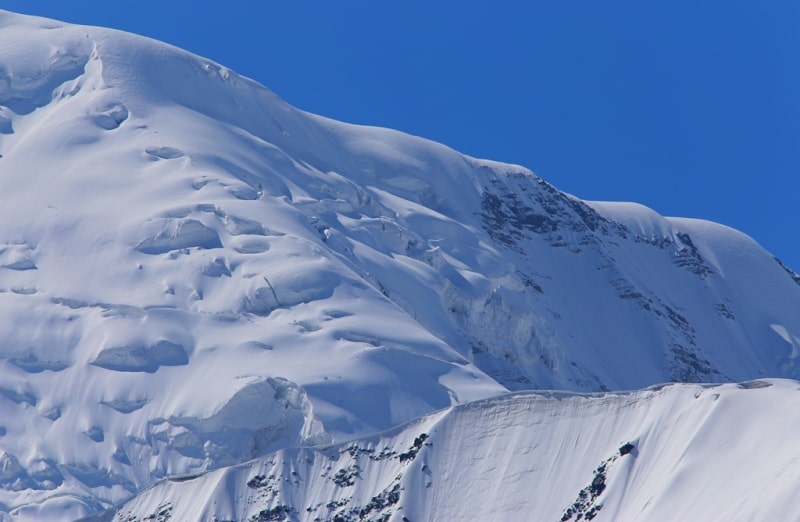
The ice and firn first flow to its lower central part, and then rush northward into a narrow passage between the rocky bastions, forming an icefall that passes into the blade of the Tramplinnoy glacier. This glacier towering 600 - 700 meters above Fortambek Glacier, is essentially a hatch from the Pamir firn plateau, and through it the main flow of firn and ice occurs.
The blocks breaking off from the glacier collapse into the ablation region of the Fortambek glacier, forming huge firn and ice cones. The clear ice of this peculiar reborn glacier traced down the Fortambek Glacier over a long distance.
On the Pamir firn plateau, accumulation continues almost throughout year. In 1976, it amounted to 94 grams per centimeter square, and on average for 1963 - 1976 - 117 grams per centimeter square. The ice temperature at a depth of 10 - 12 meters at an altitude of 5700 meters above sea level was -18 °.
Within the plateau, there are zones of ice formation - from ice and firn to intermediate between cold firn and snow firn. The snow zone on the firn plateau was not observed (Dyurgerov, Urumbaev. 1977). On the southern slope of the eastern part of the ridge of Peter I, 168 glaciers with a total area
131.1 square kilometers. Glaciers of valleys account for 62% of the number and 94% of the total area. The rest are shallow, hanging and sloping glaciers located mainly in the second tier above the tongues of larger glaciers.
More than half the area of glaciation (68 kilometers quadrant) falls on two dendritic glaciers: Devlohan and Gando. Gando Glacier (length 22.0 kilometers, area 44.6 kilometers square) is located in a relatively narrow longitudinal basin between the ridge of Peter I and its large spur - the ridge OPTE.
In the west, the basin has access to the Kirgizob river valley, through which moisture penetrates into the basin - western and south-western air currents, and the ridges closing it form a high barrier on their way, causing heavy rainfall.
The main stream of the Gando Glacier has a complex multi-chamber feeding area in the area of the junction of the Peter I and OPTE ridges (Society of Proletarian Tourism and Excursions). On the northern slope of the OPTE ridge, there is an extensive firn area of the Dorofeev Glacier, the main left tributary of the Gando glacier.
Part of the Gando glacier fills almost the entire bottom of the basin, its width gradually decreases: from 2 kilometers in the upper reaches to 500 meters in the lower part. The middle moraines formed during the confluence of the main components in the middle part of the glacier form loops characteristic of pulsating glaciers.
Maybe, the Dorofeeva glacier is pulsating. According to the participants of the 1931 expedition, this glacier burst into the Gando glacier with “a huge ice element, which at the same time overturned itself” (Five years according to the Pamir. 1935. P. 68).
In 1948, this site was relatively easy to pass (Timashev. 1949). For 8 - 9 kilometers from the end of the Gando Glacier, the moraine forms an almost continuous cover. A hilly and cellular relief with rounded hollows filled with water and gentle hills is developed here.
The lower 2 - 3 kilometers of the end are severely destroyed by subglacial flows. In addition to the Gando Glacier and its tributaries, there are 24 more glaciers in the basin, and the total glaciation area of the basin is 58.2 square kilometers.
The total area of glaciation of the Peter the Great ridge is about 490 square kilometers.
The largest glaciers of the ridge of Peter the Great.
Fortambek Glacier, with a length of 27.2 kilometers, an area of 36.4 square kilometers, located at an altitude of 2850 to 5350 meters above sea level, belongs to the Fortambek River Basin.
The Sugran Glacier, with a length of 22 kilometers, an area of 47.1 square kilometers, located at an altitude of 3280 to 6720 meters above sea level, belongs to the Sugran river basin.
The Gando Glacier, including the 22.0 km Dorofeev Glacier, an area of 44.6 square kilometers, located at an altitude of 3250 to 6350 meters above sea level, belongs to the Gando and Kirghizob river basins.
The glacier of Peter the Great, with a length of 17.2 kilometers, an area of 12.2 square kilometers, located at an altitude of 3200 to 5500 meters above sea level, belongs to the Vayzirek river basin.
The Belyaev Glacier, with a length of 13.0 kilometers, an area of 23.1 square kilometers, located at an altitude of 3900 to 6350 meters above sea level, belongs to the basin of the Garmo Glacier.
The Zyryuzamin Glacier, with a length of 13.0 kilometers, an area of 12.1 square kilometers, located at an altitude of 4140 to 5220 meters above sea level, belongs to the Zyuryuzamink river basin.
The Devlohan Glacier, with a length of 12.6 kilometers, an area of 17.4 square kilometers, located at an altitude of 3080 to 5150 meters above sea level, belongs to the basin of the tributary of the Kyrgyzizob River.
The Byrs Glacier, with a length of 11.8 kilometers, an area of 9.9 square kilometers, is located at an altitude of 2820 to 5660 meters above sea level, belongs to the basin of the tributary of the Sugran River.
The Oshanin Glacier (Muzgazy), with a length of 10.7 kilometers, an area of 15.6 square kilometers, located at an altitude of 2820 to 5660 meters above sea level, belongs to the basin of the Obihunduk river tributary.
The Shinibini Glacier, with a length of 10.3 kilometers, an area of 16.4 square kilometers, located at an altitude of 3700 to 6300 meters above sea level, belongs to the basin of the tributary of the Sugran River.
The Baralmos Glacier, with a length of 9.2 kilometers, an area of 4.9 square kilometers, is located at an altitude of 3440 to 4240 meters above sea level, belongs to the Karashura river basin.
The Kyzylsu (Miley) Glacier, with a length of 9.0 kilometers, an area of 4.9 square kilometers, is located at an altitude of 3440 to 4240 meters above sea level, belongs to the Kyzylsu River Basin
The Pamir firn plateau, with a length of 8.3 kilometers, an area of 20.9 square kilometers, located at an altitude of 4700 to 7300 meters above sea level, belongs to the basin of the Valleri and Fortambek glaciers.
Glacier 85, with a length of 8.1 kilometers, an area of 4.6 square kilometers, located at an altitude of 3380 to 4760 meters above sea level, belongs to the Weizirek river basin.
Lipsky Glacier, with a length of 8.0 kilometers, an area of 16.0 square kilometers, located at an altitude of 3800 to 5450 meters above sea level, belongs to the Fortambek Glacier Basin.
The Shapak Glacier, with a length of 8.0 kilometers, an area of 13.7 square kilometers, is located at an altitude of 3580 to 6050 meters above sea level, belongs to the tributary of the Fortambek River.
The Shagazy Glacier, with a length of 7.9 kilometers, an area of 6.2 square kilometers, located at an altitude of 2980 to 5000 meters above sea level, belongs to the Shagazy river basin.
Glacier 74, with a length of 6.6 kilometers, an area of 6.0 square kilometers, located at an altitude of 3280 to 47000 meters above sea level, belongs to the basin of the tributary of the Peter the Great Glacier.
Glacier 88, with a length of 6.6 kilometers, an area of 3.7 square kilometers, located at an altitude of 3440 to 4600 meters above sea level, belongs to the basin of the tributary of the Vaizirek river.
The Khadyrsha Glacier, with a length of 6.3 kilometers, an area of 5.6 square kilometers, located at an altitude of 3140 to 4550 meters above sea level, belongs to the basin of the Muksu River tributary.
The Egan Glacier, with a length of 6.2 kilometers, an area of 5.6 square kilometers, located at an altitude of 3540 to 4680 meters above sea level, belongs to the basin of the tributary of the Kyrgyzizob River.
The Safidak Glacier, with a length of 6.1 kilometers, an area of 6.2 square kilometers, located at an altitude of 3540 to 4360 meters above sea level, belongs to the basin of the Obihingou River tributary.
The Gando Glacier (Nadezhda), with a length of 6.0 kilometers, an area of 5.1 square kilometers, located at an altitude of 3460 to 5050 meters above sea level, belongs to the basin of the tributary of the Sugran River.
The most significant mountain spurs of the ridge of Peter the Great.
The mountain spur Kurai-Shapk, with a length of 25 kilometers, is located at an altitude of 4500 to 6447 meters above sea level.
The mountain spur of Shagazy, with a length of 16 kilometers, is located at an altitude of 3250 to 5055 meters above sea level.
The mountain spur of the OPTE, 30 km long, is located at an altitude of 4700 to 5776 meters above sea level.
The mountain spur Shaklisu, with a length of 60 kilometers, is located at an altitude of 3745 to 5403 meters above sea level.
Authority:
"Glaciers." L.D. Dolgushin, G.B. Osipova. Series "Nature of the world." Moscow, the publishing house "Thought". 1989.