


![]()
You are here
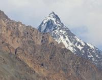
Mazorskiy ridge.
Tours in mountains of Mazorskiy range in Tajikistan.
“It was like we were walking on a taut drum skin. At 6 o'clock the sun set. The shadows from the mountains in the west ran across the plain so quickly that the eye could barely follow them. In the east, shadows crept more slowly along the slopes of the mountains; soon only their highest pyramidal peaks remained illuminated by the sun.
A quarter of an hour later the entire area was shrouded in twilight. The mountains in the east stood out against the dark sky as bluish-white cold ghosts, while the mountains in the west darkened as black silhouettes against a horizon glittering with bright azure and purple tones.”
Sven Gediin (Hedin). "Pamir - Tibet - Eastern Turkestan."
Nature of Mazorskiy Range inPamirs.
Mazorskiy range is located in Western Pamir mountains, located in Sangvor region of Republic of Tajikistan. The Mazorskiy ridge stretches from southeast to northwest for 41 kilometers. In the southeast, the ridge borders the Darvaz ridge with a length of 203 kilometers.
In the northwest, the ridge borders the Obihingou River valley, which is more than 200 kilometers long, which is formed at an altitude of 2582 meters above sea level from the confluence of the Garmo and Kyrgyzob rivers. In the south, the ridge borders the Obimazor River valley, 35 kilometers long, which originates from the end of the Mazorskiy glacier at an altitude of 3256 meters above sea level.
The mouth of the river is located at an altitude of 2187 meters above sea level, the river is a left tributary of the Obihingou River. The highest peak of the Mazorskiy ridge is the Tekharv peak, 5963 meters above sea level, located in the southeast, at the beginning of the ridge, in the sharp protrusion of the Darvaz ridge.
The second highest is the unnamed peak, 5888.2 meters above sea level, located in the central part of the Mazorskiy Mountains. The summit is the uppermost boundary of the Bijau, Batrut and Batrut East glaciers. On the western slope of the Mazor ridge there is a glacier of the same name with a length of 16.2 kilometers, which gives rise to the Obimazor River.
On the northern slope of the Mazorskiy ridge there are powerful glaciers, the upper boundary of which lies in the main ridge of the ridge. The glaciers stretch from southeast to northwest: Zordibirausa, Suraisha, Minadu, Iskogach, Batrut East, Batrut, Bijau and Nusoyak.
58 glaciers with an area of 97.4 square kilometers are located on the northeastern slope of the Mazar ridge, the average height is 5500 meters above sea level. Of these, the largest is the Bartrut East glacier located on the northern slope of the ridge.
Geographic coordinates of Mazorskiy Range: N38°43'28 E71°27'22
Authority and photos by:
Alexander Petrov.