


![]()
You are here
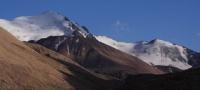
Glaciers in ridge of Saur.

In Saur Mountains Tours.
“Willpower is the first and most important quality of a skilled researcher. Only knowing how to control his will, he can hope to overcome the difficulties that nature raises on his way."
Amundsen Roal.
Eastern Kazakhstan and New Silk Road.
Saur - a mountain range of latitudinal strike, which is part of the Saur-Tarbagatai mountain country. Its strongly dissected southern slope is short and steep, the northern one is gentle and long, cut through by deep river valleys.
Most of the ridge with its highest point, Muztau Mountain, 3816 meters above sea level lies within China. On the territory of Kazakhstan, the length of the ridge is about 30 kilometers, the height of the ridge is from 3400 meters above sea level in the west to 3800 meters above sea level in the east.
The rivers of the northern slope of the ridge belong to the basin of Zaisan Lake and the Black Irtysh River. A number of small rivers are lost in the sands upon exiting the mountains. The relief of the upper parts of the Saur ridge is characterized by relatively weak dissection, the tops of the mountains are flat, sometimes dome-shaped.
The climate of Saur is sharply continental. The average annual air temperature in the glacial zone of the ridge is - 7 - 9 °, the average temperature of the cold period -14 - 16 °, warm - +6 - 8 °. In winter, the temperature drops to - 40 - 45 °, in the summer on hot days it rises to + 20 °.
Annual precipitation is about 500 - 600 mm. In the glacial precipitation zone, not only in winter, but also in the summer fall in the form of snow. Glaciers are fed both by atmospheric precipitation brought by westerly and north-westerly winds, and by snow from flat watershed spaces and its concentration on the glaciers of the leeward slopes.
In accordance with this, all modern glaciers have northeastern, northern, and northwestern exposures, occupying the legacy of the more extensive Quaternary glaciation, and all of them are located on the northern slope of the ridge.
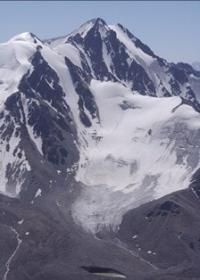
Currently, there are 18 glaciers with a total area of 16.6 kilometers square on the Saur Ridge in Kazakhstan, and their water supply is 0.6 kilometers cubic. Moraine is covered with 1.8 kilometers of square glacial surface.
The open ends of the glaciers are located in the altitude range of 3000 - 3370 meters above sea level, and the ends of the glaciers buried under the moraine descend 40 - 50 meters below. In the eastern part of the ridge, 6 glaciers form a compact group with merged food basins (sources Karaungur and Kenderlyk rivers).
Glaciers prevail in number (61%), and valley glaciers prevail in area (51%). The largest glacier is Kosayryk, with a length of 4 kilometers and an area of 3.7 square kilometers, located in the eastern part of the ridge in the headwaters of the river of the same name.
The glacier regime of the Saur ridge has not been studied. There is evidence that the Aba glacier for 57 years (from 1901 to 1958) retreated by about 90 meters, the Kosayryk glacier from 1907 to 1958 retreated by 150 - 250 meters. But some glaciers (Orto-Bokan, Ulku-Bokan and etc.) against the background of a general retreat, sometimes, apparently, come.
Some glaciers over the past decades are in a stationary state (Seliverstov. 1962, Catalog of glaciers. 1969).
Authority:
"Glaciers." L.D. Dolgushin, G.B. Osipova. Series "Nature of the world." Moscow, the publishing house "Thought". 1989.
Photos by
Roman Stesenko.